 |
|
Location
& QuickFacts
|
FAA
Information Effective: |
2008-06-05 |
|
Airport
Identifier: |
67II |
|
Airport
Status: |
Operational |
|
Longitude/Latitude: |
085-35-32.0000W/39-22-17.0000N
-85.592222/39.371389 (Estimated) |
|
Elevation: |
875 ft / 266.70 m (Estimated) |
|
Land: |
0 acres |
|
From nearest
city: |
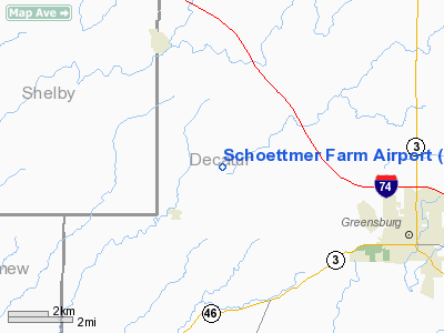
5 nautical miles SE of Greensburg, IN |
|
Location: |
Decatur County, IN |
|
Magnetic
Variation: |
03W (1990) |
Owner
& Manager
|
Ownership: |
Privately
owned |
|
Owner: |
Stanley Schoettmer |
|
Address: |
4505 North State Rt 3
Greensburg, IN 47240 |
|
Phone
number: |
812-663-5044 |
|
Manager: |
Stanley Schoettmer |
|
Address: |
4505 North State Rt 3
Greensburg, IN 47240 |
|
Phone
number: |
812-663-5044 |
Airport Operations
and Facilities
|
Airport
Use: |
Private |
|
Wind indicator: |
Yes |
|
Segmented
Circle: |
No |
|
Control
Tower: |
No |
|
Sectional
chart: |
St Louis |
|
Region: |
AGL - Great Lakes |
|
Boundary
ARTCC: |
ZID - Indianapolis |
|
Tie-in
FSS: |
HUF - Terre Haute |
|
FSS Toll
Free: |
1-800-WX-BRIEF |
|
Runway Information
Runway 18/36
|
Dimension: |
1800 x 80 ft
/ 548.6 x 24.4 m |
|
Surface: |
TURF, |
|
|
Runway 18 |
Runway 36 |
|
Traffic
Pattern: |
Left |
Left |
|
Obstruction: |
|
50 ft trees, 450.0 ft from runway |
|
Radio Navigation
Aids
|
ID |
Type |
Name |
Ch |
Freq |
Var |
Dist |
|
BA |
NDB |
Clifs |
|
410.00 |
03W |
10.9 nm |
|
HLB |
NDB |
Batesville |
|
254.00 |
02W |
15.6 nm |
|
OVO |
NDB |
North Vernon |
|
374.00 |
02W |
19.3 nm |
|
HFY |
NDB |
Greenwood |
|
398.00 |
02W |
27.9 nm |
|
UWL |
NDB |
New Castle |
|
385.00 |
02W |
33.1 nm |
|
EQZ |
NDB |
Captain |
|
308.00 |
02W |
35.1 nm |
|
IMS |
NDB |
Madison |
|
404.00 |
03W |
37.2 nm |
|
OXD |
NDB |
Oxford |
|
282.00 |
04W |
38.6 nm |
|
UMP |
NDB |
Metropolitan |
|
338.00 |
03W |
40.1 nm |
|
AI |
NDB |
Video |
|
371.00 |
03W |
42.1 nm |
|
UR |
NDB |
Burln |
|
321.00 |
04W |
42.9 nm |
|
HZP |
NDB |
Zionsville |
|
248.00 |
03W |
45.7 nm |
|
HAO |
NDB |
Hamilton |
|
260.00 |
04W |
47.4 nm |
|
SHB |
VORTAC |
Shelbyville |
057X |
112.00 |
01E |
19.0 nm |
|
RID |
VORTAC |
Richmond |
043X |
110.60 |
03W |
41.8 nm |
|
VHP |
VORTAC |
Brickyard |
110X |
116.30 |
01E |
44.7 nm |
|
CVG |
VORTAC |
Cincinnati |
120X |
117.30 |
04W |
46.6 nm |
|
ABB |
VORTAC |
Nabb |
071X |
112.40 |
01E |
47.1 nm |
|
OOM |
VORTAC |
Hoosier |
039X |
110.20 |
02W |
49.4 nm |
|
IND |
VOT |
Indianapolis Intl |
|
109.60 |
|
38.4 nm |
Remarks
- PRVDD
THE AREA 125 FT EITHER SIDE OF RY CTR & 200 FT OFF RY END BE CLEAR
OF ANY OBSTN & ANY OBSTN IN THE APCH SLOPE ARE REMOVED/LOWERED;
OR THE RWY THR IS DSPLCD & CLEARLY MKD SO AS TO PRVD A MIN 20:1
APCH CLNC OVER THE OBSTN.
Based Aircraft
|
Aircraft
based on field: |
1 |
|
Single Engine
Airplanes: |
1 |
Schoettmer Farm Airport
Address:
Decatur County, IN
Tel:
812-663-5044
Images
and information placed above are from
http://www.airport-data.com/airport/67II/
We
thank them for the data!
| General
Info |
| Country |
United
States |
| State |
INDIANA
|
| FAA ID |
67II |
| Latitude |
39-22-17.000N
|
| Longitude |
085-35-32.000W
|
| Elevation |
875 feet
|
| Near City |
GREENSBURG
|
We don't guarantee the information is fresh and accurate. The data may
be wrong or outdated.
For more up-to-date information please refer to other sources.
|
|


