 |
|
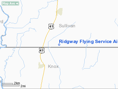
Ridgway Flying Service Airport |
Location
& QuickFacts
|
FAA
Information Effective: |
2008-06-05 |
|
Airport
Identifier: |
II30 |
|
Airport
Status: |
Operational |
|
Longitude/Latitude: |
087-24-06.0660W/38-54-24.1610N
-87.401685/38.906711 (Estimated) |
|
Elevation: |
510 ft / 155.45 m (Estimated) |
|
Land: |
0 acres |
|
From nearest
city: |
4 nautical miles N of Carlisle, IN |
|
Location: |
Sullivan County, IN |
|
Magnetic
Variation: |
01W (1985) |
Owner & Manager
|
Ownership: |
Privately
owned |
|
Owner: |
Rick J. Ridgway |
|
Address: |
Rr 3, Box 62
Carlisle, IN 47838 |
|
Phone
number: |
812-398-2439 |
|
Address: |
|
Airport
Operations and Facilities
|
Airport
Use: |
Private |
|
Wind indicator: |
No |
|
Segmented
Circle: |
No |
|
Control
Tower: |
No |
|
Lighting
Schedule: |
PHONE REQ
FOR LIRL RY 18/36 CALL 812-398-2439. |
|
Landing
fee charge: |
No |
|
Sectional
chart: |
St Louis |
|
Region: |
AGL - Great Lakes |
|
Boundary
ARTCC: |
ZID - Indianapolis |
|
Tie-in
FSS: |
HUF - Terre Haute |
|
FSS on
Airport: |
No |
|
FSS Toll
Free: |
1-800-WX-BRIEF |
|
Runway Information
Runway 09/27
|
Dimension: |
1900 x 60 ft
/ 579.1 x 18.3 m |
|
Surface: |
TURF, |
|
|
Runway 09 |
Runway 27 |
|
Traffic
Pattern: |
Left |
Left |
|
Obstruction: |
30 ft pline, 1200.0 ft from runway |
30 ft pline, 2500.0 ft from runway |
|
Runway 18/36
|
Dimension: |
2500 x 65 ft
/ 762.0 x 19.8 m |
|
Surface: |
TURF, |
|
Edge Lights: |
Low |
|
|
Runway 18 |
Runway 36 |
|
Traffic
Pattern: |
Left |
Left |
|
Radio Navigation
Aids
|
ID |
Type |
Name |
Ch |
Freq |
Var |
Dist |
|
SIV |
NDB |
Sullivan |
|
326.00 |
02W |
12.6 nm |
|
PLX |
NDB |
Palestine |
|
391.00 |
00W |
12.9 nm |
|
OEA |
NDB |
Vincennes |
|
251.00 |
00E |
14.8 nm |
|
DCY |
NDB |
Washington |
|
212.00 |
03W |
17.9 nm |
|
AJG |
NDB |
Mount Carmel |
|
524.00 |
02W |
23.3 nm |
|
HU |
NDB |
Yinno |
|
245.00 |
02W |
28.9 nm |
|
CZB |
NDB |
Casey |
|
359.00 |
00E |
36.8 nm |
|
OLY |
NDB |
Olney |
|
272.00 |
00W |
37.9 nm |
|
BM |
NDB |
Claye |
|
382.00 |
02W |
38.6 nm |
|
BFR |
NDB |
Bedford |
|
344.00 |
02W |
45.3 nm |
|
RRJ |
NDB |
Oranj |
|
368.00 |
02W |
46.9 nm |
|
FNZ |
NDB |
Ferdinand |
|
239.00 |
00E |
47.6 nm |
|
MT |
NDB |
Zebre |
|
347.00 |
00E |
48.3 nm |
|
PRG |
NDB |
Paris |
|
341.00 |
01E |
49.2 nm |
|
LWV |
VOR/DME |
Lawrenceville |
025X |
108.80 |
01W |
12.5 nm |
|
RSV |
VOR/DME |
Robinson |
021X |
108.40 |
02E |
13.3 nm |
|
SAM |
VOR/DME |
Samsville |
113X |
116.60 |
03E |
40.9 nm |
|
HNB |
VOR/DME |
Huntingburg |
029X |
109.20 |
00E |
44.7 nm |
|
TTH |
VORTAC |
Terre Haute |
100X |
115.30 |
02E |
35.7 nm |
|
OOM |
VORTAC |
Hoosier |
039X |
110.20 |
02W |
39.5 nm |
Remarks
- PRVDD
AREA 125 FT EITHER SIDE OF RY CL & 200 FT OFF RY END BY CLEAR OF
OBSTN; OBSTN IN RY APCH SLOPE REMOVED/LOWERED OR THR DSPLCD & MKD
TO PRVD MIN 20:1 CLNC OVER OBSTN.
Based Aircraft
|
Aircraft
based on field: |
2 |
|
Single Engine
Airplanes: |
2 |
Ridgway Flying Service Airport
Address:
Sullivan County, IN
Tel:
812-398-2439
Images
and information placed above are from
http://www.airport-data.com/airport/II30/
We
thank them for the data!
| General
Info |
| Country |
United
States |
| State |
INDIANA
|
| FAA ID |
II30 |
| Latitude |
38-54-24.161N
|
| Longitude |
087-24-06.066W
|
| Elevation |
510 feet
|
| Near City |
CARLISLE
|
We don't guarantee the information is fresh and accurate. The data may
be wrong or outdated.
For more up-to-date information please refer to other sources.
|
|


