 |
|
Location
& QuickFacts
|
FAA
Information Effective: |
2008-06-05 |
|
Airport
Identifier: |
7II7 |
|
Airport
Status: |
Operational |
|
Longitude/Latitude: |
085-28-59.9300W/41-17-50.1690N
-85.483314/41.297269 (Estimated) |
|
Elevation: |
920 ft / 280.42 m (Estimated) |
|
Land: |
0 acres |
|
From nearest
city: |
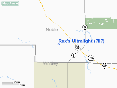
2 nautical miles SE of Wolflake, IN |
|
Location: |
Noble County, IN |
|
Magnetic
Variation: |
03W (1985) |
Owner
& Manager
|
Ownership: |
Privately
owned |
|
Owner: |
Bruce E. Rex |
|
Address: |
1079 N. Center Crt
Columbia City, IN 46725 |
|
Phone
number: |
219-244-6119 |
|
Address: |
|
Airport Operations
and Facilities
|
Airport
Use: |
Private |
|
Segmented
Circle: |
No |
|
Control
Tower: |
No |
|
Sectional
chart: |
Chicago |
|
Region: |
AGL - Great Lakes |
|
Boundary
ARTCC: |
ZAU - Chicago |
|
Tie-in
FSS: |
HUF - Terre Haute |
|
FSS on
Airport: |
No |
|
FSS Toll
Free: |
1-800-WX-BRIEF |
|
Runway Information
Runway 18S/36S
|
Dimension: |
650 x 65 ft
/ 198.1 x 19.8 m |
|
Surface: |
TURF, |
|
|
Runway 18S |
Runway 36S |
|
Traffic
Pattern: |
Left |
Left |
|
Radio Navigation
Aids
|
ID |
Type |
Name |
Ch |
Freq |
Var |
Dist |
|
HHG |
NDB |
Huntington |
|
417.00 |
03W |
26.6 nm |
|
ANQ |
NDB |
Angola |
|
347.00 |
05W |
27.3 nm |
|
IRS |
NDB |
Sturgis |
|
382.00 |
04W |
31.1 nm |
|
RCR |
NDB |
Rochester |
|
216.00 |
03W |
34.9 nm |
|
IWH |
NDB |
Wabash |
|
329.00 |
03W |
35.1 nm |
|
HAI |
NDB |
Three Rivers |
|
407.00 |
02W |
40.0 nm |
|
CPB |
NDB |
Culver |
|
391.00 |
01W |
41.0 nm |
|
BYN |
NDB |
Bryan |
|
260.00 |
04W |
47.2 nm |
|
VFU |
NDB |
Stanley |
|
411.00 |
05W |
47.3 nm |
|
DFI |
NDB |
Defiance |
|
246.00 |
05W |
47.7 nm |
|
OLK |
VOR |
Wolf Lake |
|
110.40 |
03W |
3.1 nm |
|
MZZ |
VOR/DME |
Marion |
023X |
108.60 |
03W |
49.1 nm |
|
FWA |
VORTAC |
Fort Wayne |
125X |
117.80 |
00E |
23.3 nm |
|
GSH |
VORTAC |
Goshen |
084X |
113.70 |
00E |
28.1 nm |
|
GIJ |
VORTAC |
Gipper |
101X |
115.40 |
00E |
47.1 nm |
|
GUS |
VORTAC |
Grissom |
21Y |
108.45 |
02W |
49.6 nm |
|
FWA |
VOT |
Fort Wayne Baer |
|
111.00 |
|
23.3 nm |
Based Aircraft
|
Aircraft
based on field: |
1 |
|
Single Engine
Airplanes: |
1 |
Rex's Ultralight
Address:
Noble County, IN
Tel:
219-244-6119
Images
and information placed above are from
http://www.airport-data.com/airport/7II7/
We
thank them for the data!
| General
Info |
| Country |
United
States |
| State |
INDIANA
|
| FAA ID |
7II7 |
| Latitude |
41-17-50.169N
|
| Longitude |
085-28-59.930W
|
| Elevation |
920 feet
|
| Near City |
WOLFLAKE
|
We don't guarantee the information is fresh and accurate. The data may
be wrong or outdated.
For more up-to-date information please refer to other sources.
|
|


