 |
|
|
|
|
|
Location
& QuickFacts
|
FAA
Information Effective: |
2008-06-05 |
|
Airport
Identifier: |
25IN |
|
Airport
Status: |
Operational |
|
Longitude/Latitude: |
085-25-09.9280W/41-42-10.1820N
-85.419424/41.702828 (Estimated) |
|
Elevation: |
879 ft / 267.92 m (Surveyed) |
|
Land: |
25 acres |
|
From nearest
city: |
1 nautical miles S of Howe, IN |
|
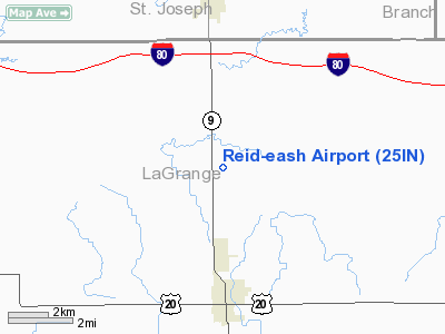
Location: |
Lagrange County, IN |
|
Magnetic
Variation: |
03W (1985) |
Owner
& Manager
|
Ownership: |
Privately
owned |
|
Owner: |
William Reid |
|
Address: |
Po Box 18
Howe, IN 46746 |
|
Phone
number: |
219-562-2132
DURING WINTER MONTHS THE OWNER'S PHONE NUMBER IN FLORIDA
IS 941-729-5125. |
|
Address: |
|
Airport Operations
and Facilities
|
Airport
Use: |
Private |
|
Wind indicator: |
Yes |
|
Segmented
Circle: |
No |
|
Control
Tower: |
No |
|
Lighting
Schedule: |
RDO REQ
RY LGTS AVAILABLE BY REQ ONLY - 122.8. |
|
Beacon
Color: |
Clear-Green (lighted land airport) |
|
Landing
fee charge: |
No |
|
Sectional
chart: |
Chicago |
|
Region: |
AGL - Great Lakes |
|
Traffic
Pattern Alt: |
1000 ft |
|
Boundary
ARTCC: |
ZAU - Chicago |
|
Tie-in
FSS: |
HUF - Terre Haute |
|
FSS on
Airport: |
No |
|
FSS Toll
Free: |
1-800-WX-BRIEF |
Airport Communications
|
Unicom: |
122.800
UNICOM NOT MONTRD. |
Airport Services
|
Bottled
Oxygen: |
NONE |
|
Bulk Oxygen: |
NONE |
|
Runway Information
Runway 18/36
|
Dimension: |
2635 x 120 ft
/ 803.1 x 36.6 m |
|
Surface: |
TURF, Fair Condition |
|
Edge Lights: |
Low
NSTD LIRL & THR LGTS. RWY WITHIN DSPLCD THRS NOT LGTD. |
|
|
Runway 18 |
Runway 36 |
|
Traffic
Pattern: |
Left |
Left |
|
Displaced
threshold: |
225.00 ft
NGT DSPLCD THR 405'. |
295.00 ft |
|
Obstruction: |
5 ft brush
APCH RATIO 20:1 AT DSPLCD THR OVER 55'TREES 875'FM RWY PHYSICAL
END. |
15 ft road, 10.0 ft from runway
APCH RATIO 20:1 AT DSPLCD THR. |
|
Radio Navigation
Aids
|
ID |
Type |
Name |
Ch |
Freq |
Var |
Dist |
|
IRS |
NDB |
Sturgis |
|
382.00 |
04W |
6.7 nm |
|
ANQ |
NDB |
Angola |
|
347.00 |
05W |
15.4 nm |
|
HAI |
NDB |
Three Rivers |
|
407.00 |
02W |
17.2 nm |
|
BT |
NDB |
Batol |
|
272.00 |
04W |
41.0 nm |
|
BYN |
NDB |
Bryan |
|
260.00 |
04W |
44.9 nm |
|
DFI |
NDB |
Defiance |
|
246.00 |
05W |
49.9 nm |
|
OLK |
VOR |
Wolf Lake |
|
110.40 |
03W |
27.6 nm |
|
AZO |
VOR/DME |
Kalamazoo |
027X |
109.00 |
01W |
32.7 nm |
|
LFD |
VOR/DME |
Litchfield |
049X |
111.20 |
05W |
36.4 nm |
|
ELX |
VOR/DME |
Keeler |
113X |
116.60 |
00E |
41.2 nm |
|
GSH |
VORTAC |
Goshen |
084X |
113.70 |
00E |
29.4 nm |
|
BTL |
VORTAC |
Battle Creek |
031X |
109.40 |
02W |
37.2 nm |
|
GIJ |
VORTAC |
Gipper |
101X |
115.40 |
00E |
40.5 nm |
|
FWA |
VORTAC |
Fort Wayne |
125X |
117.80 |
00E |
44.7 nm |
|
FWA |
VOT |
Fort Wayne Baer |
|
111.00 |
|
44.8 nm |
Remarks
- TURF
ADJ RWY USED AS TWY BOTH SIDES.
Based Aircraft
|
Aircraft
based on field: |
4 |
|
Single Engine
Airplanes: |
2 |
|
Ultralights: |
2 |
Operational Statistics
Time
Period: 1983-06-22 - 1984-06-20
|
Aircraft
Operations: |
50/Week |
|
General Aviation
Local: |
57.7% |
|
General Aviation
Itinerant: |
42.3% |
Reid-eash Airport
Address:
Lagrange County, IN
Tel:
219-562-2132,
941-729-5125
Images
and information placed above are from
http://www.airport-data.com/airport/25IN/
We
thank them for the data!
| General
Info |
| Country |
United
States |
| State |
INDIANA
|
| FAA ID |
25IN |
| Latitude |
41-42-10.182N
|
| Longitude |
085-25-09.928W
|
| Elevation |
879 feet
|
| Near City |
HOWE |
We don't guarantee the information is fresh and accurate. The data may
be wrong or outdated.
For more up-to-date information please refer to other sources.
|
|


