 |
|
|
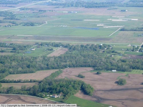 |
(Click on the photo to enlarge) |
|
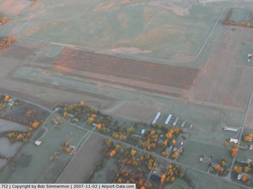 |
(Click on the photo to enlarge) |
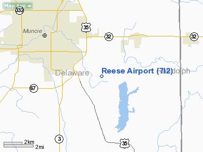
Location
& QuickFacts
|
FAA
Information Effective: |
2008-06-05 |
|
Airport
Identifier: |
7I2 |
|
Airport
Status: |
Operational |
|
Longitude/Latitude: |
085-18-59.8900W/40-09-15.1590N
-85.316636/40.154211 (Estimated) |
|
Elevation: |
991 ft / 302.06 m (Surveyed) |
|
Land: |
49 acres |
|
From nearest
city: |
3 nautical miles SE of Muncie, IN |
|
Location: |
Delaware County, IN |
|
Magnetic
Variation: |
03W (1985) |
Owner
& Manager
|
Ownership: |
Privately
owned |
|
Owner: |
Reese Flying Svc Inc |
|
Address: |
4301 Scr-388 East
Muncie, IN 47302 |
|
Phone
number: |
765-284-9611 |
|
Manager: |
Mary Reese |
|
Address: |
11707 E.c.r. 250n - Orr Rd
Albany, IN 47320 |
|
Phone
number: |
765-289-8753 |
Airport Operations
and Facilities
|
Airport
Use: |
Open
to public |
|
Wind indicator: |
Yes |
|
Segmented
Circle: |
No |
|
Control
Tower: |
No |
|
Lighting
Schedule: |
PHONE REQ
FOR LIRL RY 09/27 CALL 765-284-9611; 765-289-8753 OR 765-286-9074. |
|
Landing
fee charge: |
No |
|
Sectional
chart: |
Chicago |
|
Region: |
AGL - Great Lakes |
|
Traffic
Pattern Alt: |
800 ft |
|
Boundary
ARTCC: |
ZID - Indianapolis |
|
Tie-in
FSS: |
HUF - Terre Haute |
|
FSS on
Airport: |
No |
|
FSS Toll
Free: |
1-800-WX-BRIEF |
|
NOTAMs
Facility: |
HUF (NOTAM-d service avaliable) |
Airport Communications
|
CTAF: |
122.700 |
|
Unicom: |
122.700
|
Airport Services
|
Fuel
available: |
100LLMOGAS |
|
Airframe
Repair: |
MINOR |
|
Power
Plant Repair: |
MINOR |
|
Runway Information
Runway 09/27
|
Dimension: |
2800 x 50 ft
/ 853.4 x 15.2 m |
|
Surface: |
ASPH, Fair Condition |
|
Edge Lights: |
Non-standard lighting system
LGTS ARE > 10 FT FM RY EDGE |
|
|
Runway 09 |
Runway 27 |
|
Longitude: |
085-19-26.2300W |
085-18-50.1800W |
|
Latitude: |
40-09-19.3500N |
40-09-18.3700N |
|
Elevation: |
991.00 ft |
991.00 ft |
|
Traffic
Pattern: |
Left |
Left |
|
Markings: |
Basic, Good Condition |
Basic, Good Condition |
|
Runway End
Identifier: |
No |
No |
|
Centerline
Lights: |
No |
No |
|
Touchdown
Lights: |
No |
No |
|
Obstruction: |
10 ft crops, 230.0 ft from runway, 3:1 slope
to clear |
15 ft road, 315.0 ft from runway, 7:1 slope
to clear |
|
Radio Navigation
Aids
|
ID |
Type |
Name |
Ch |
Freq |
Var |
Dist |
|
AI |
NDB |
Video |
|
371.00 |
03W |
10.3 nm |
|
UWL |
NDB |
New Castle |
|
385.00 |
02W |
16.5 nm |
|
PLD |
NDB |
Portland |
|
257.00 |
03W |
23.6 nm |
|
UMP |
NDB |
Metropolitan |
|
338.00 |
03W |
36.2 nm |
|
VES |
NDB |
Versailles |
|
356.00 |
04W |
36.6 nm |
|
CQA |
NDB |
Lakefield |
|
205.00 |
04W |
39.7 nm |
|
HHG |
NDB |
Huntington |
|
417.00 |
03W |
42.7 nm |
|
IWH |
NDB |
Wabash |
|
329.00 |
03W |
42.7 nm |
|
HZP |
NDB |
Zionsville |
|
248.00 |
03W |
44.8 nm |
|
OXD |
NDB |
Oxford |
|
282.00 |
04W |
46.1 nm |
|
HFY |
NDB |
Greenwood |
|
398.00 |
02W |
47.5 nm |
|
HLB |
NDB |
Batesville |
|
254.00 |
02W |
48.4 nm |
|
MIE |
VOR/DME |
Muncie |
091X |
114.40 |
03W |
6.1 nm |
|
MZZ |
VOR/DME |
Marion |
023X |
108.60 |
03W |
26.3 nm |
|
DQN |
VOR/DME |
Dayton |
092X |
114.50 |
01W |
43.1 nm |
|
RID |
VORTAC |
Richmond |
043X |
110.60 |
03W |
32.6 nm |
|
SHB |
VORTAC |
Shelbyville |
057X |
112.00 |
01E |
39.1 nm |
|
OKK |
VORTAC |
Kokomo |
082X |
113.50 |
00E |
40.7 nm |
|
GUS |
VORTAC |
Grissom |
21Y |
108.45 |
02W |
48.3 nm |
|
FWA |
VORTAC |
Fort Wayne |
125X |
117.80 |
00E |
49.9 nm |
|
FWA |
VOT |
Fort Wayne Baer |
|
111.00 |
|
49.9 nm |
Remarks
Based Aircraft
|
Aircraft
based on field: |
19 |
|
Single Engine
Airplanes: |
19 |
Operational Statistics
Time
Period: 2005-06-01 - 2006-05-31
|
Aircraft
Operations: |
154/Week |
|
General Aviation
Local: |
90.0% |
|
General Aviation
Itinerant: |
10.0% |
Reese Airport
Address:
Delaware County, IN
Tel:
765-284-9611,
765-289-8753
Images
and information placed above are from
http://www.airport-data.com/airport/7I2/
We
thank them for the data!
| General
Info |
| Country |
United
States |
| State |
INDIANA
|
| FAA ID |
7I2 |
| Latitude |
40-09-15.159N
|
| Longitude |
085-18-59.890W
|
| Elevation |
991 feet
|
| Near City |
MUNCIE
|
We don't guarantee the information is fresh and accurate. The data may
be wrong or outdated.
For more up-to-date information please refer to other sources.
|
|


