|
|
|
 |
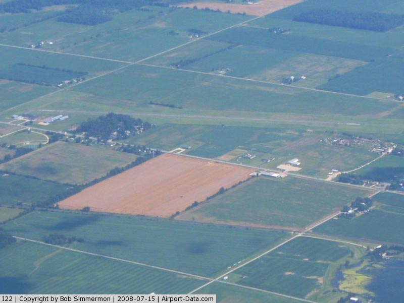
(Click on the photo to enlarge) |
|
 |
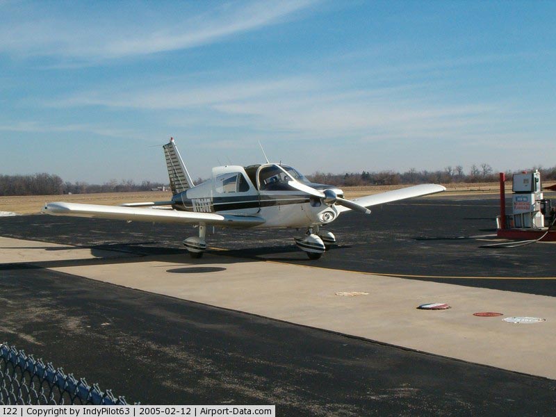
(Click on the photo to enlarge) |
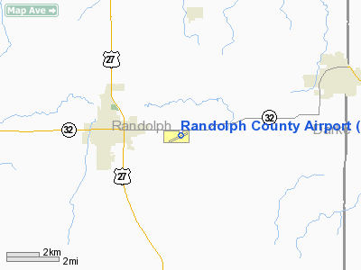
Location
& QuickFacts
|
FAA
Information Effective: |
2008-06-05 |
|
Airport
Identifier: |
I22 |
|
Airport
Status: |
Operational |
|
Longitude/Latitude: |
084-55-32.5000W/40-10-08.2000N
-84.925694/40.168944 (Estimated) |
|
Elevation: |
1119 ft / 341.07 m (Surveyed) |
|
Land: |
70 acres |
|
From nearest
city: |
3 nautical miles E of Winchester, IN |
|
Location: |
Randolph County, IN |
|
Magnetic
Variation: |
02W (1980) |
Owner
& Manager
|
Ownership: |
Publicly
owned |
|
Owner: |
Randolph Co Boac |
|
Address: |
2937 E State Rd32
Winchester, IN 47394 |
|
Phone
number: |
765-584-3611 |
|
Manager: |
Eric Livingston |
|
Address: |
2937 E State Rd 32
Winchester, IN 47394 |
|
Phone
number: |
765-584-3611 |
Airport Operations
and Facilities
|
Airport
Use: |
Open
to public |
|
Wind indicator: |
Yes |
|
Segmented
Circle: |
No |
|
Control
Tower: |
No |
|
Lighting
Schedule: |
DUSK-DAWN
MIRL RY 07/25 PRESET LOW INTST; TO INCR INTST & ACTVT
VASIS & REILS RYS 07 & 25 - CTAF. |
|
Beacon
Color: |
Clear-Green (lighted land airport) |
|
Landing
fee charge: |
No |
|
Sectional
chart: |
Detroit |
|
Region: |
AGL - Great Lakes |
|
Traffic
Pattern Alt: |
800 ft |
|
Boundary
ARTCC: |
ZID - Indianapolis |
|
Tie-in
FSS: |
HUF - Terre Haute |
|
FSS on
Airport: |
No |
|
FSS Toll
Free: |
1-800-WX-BRIEF |
|
NOTAMs
Facility: |
HUF (NOTAM-d service avaliable) |
|
Federal
Agreements: |
N |
Airport Communications
|
CTAF: |
123.000 |
|
Unicom: |
123.000
|
Airport
Services
|
Fuel
available: |
100LLA |
|
Airframe
Repair: |
MINOR |
|
Power
Plant Repair: |
MINOR |
|
Bottled
Oxygen: |
NONE |
|
Bulk Oxygen: |
NONE |
|
Runway Information
Runway 07/25
|
Dimension: |
3977 x 50 ft
/ 1212.2 x 15.2 m |
|
Surface: |
ASPH, Good Condition |
|
Weight Limit: |
Single wheel: 12000 lbs. |
|
Edge Lights: |
Medium |
|
|
Runway 07 |
Runway 25 |
|
Longitude: |
084-56-01.4977W |
084-55-12.5970W |
|
Latitude: |
40-10-01.9724N |
40-10-13.6721N |
|
Elevation: |
1115.00 ft |
1117.00 ft |
|
Alignment: |
73 |
127 |
|
Traffic
Pattern: |
Left |
Left |
|
Markings: |
Non-precision instrument, Good Condition |
Non-precision instrument, Good Condition |
|
Crossing
Height: |
25.00 ft |
21.00 ft |
|
Displaced
threshold: |
0.00 ft |
194.00 ft |
|
VASI: |
2-box on left side |
2-box on left side |
|
Visual Glide
Angle: |
3.00° |
3.00° |
|
Runway End
Identifier: |
Yes |
Yes |
|
Centerline
Lights: |
No |
No |
|
Touchdown
Lights: |
No |
No |
|
Obstruction: |
10 ft crops, 300.0 ft from runway, 250 ft right
of centerline, 10:1 slope to clear |
15 ft road, 201.0 ft from runway
APCH RATIO 26:1 AT DSPLCD THR. |
|
Runway 09/27
|
Dimension: |
1960 x 105 ft
/ 597.4 x 32.0 m |
|
Surface: |
TURF, Fair Condition |
|
|
Runway 09 |
Runway 27 |
|
Longitude: |
084-55-35.9582W |
084-55-10.7313W |
|
Latitude: |
40-10-09.2715N |
40-10-08.6202N |
|
Elevation: |
1119.00 ft |
1118.00 ft |
|
Alignment: |
92 |
127 |
|
Traffic
Pattern: |
Left |
Left |
|
Markings: |
None, |
None, |
|
Displaced
threshold: |
0.00 ft |
302.00 ft
DSPLCD THR MKD WITH CONES. |
|
Runway End
Identifier: |
No |
No |
|
Centerline
Lights: |
No |
No |
|
Touchdown
Lights: |
No |
No |
|
Obstruction: |
10 ft crops, 127 ft left of centerline |
15 ft road, 5.0 ft from runway
APCH RATIO 20:1 AT DSPLCD THR. |
|
Radio Navigation
Aids
|
ID |
Type |
Name |
Ch |
Freq |
Var |
Dist |
|
PLD |
NDB |
Portland |
|
257.00 |
03W |
17.3 nm |
|
VES |
NDB |
Versailles |
|
356.00 |
04W |
18.6 nm |
|
CQA |
NDB |
Lakefield |
|
205.00 |
04W |
25.1 nm |
|
UWL |
NDB |
New Castle |
|
385.00 |
02W |
25.1 nm |
|
AI |
NDB |
Video |
|
371.00 |
03W |
27.5 nm |
|
OXD |
NDB |
Oxford |
|
282.00 |
04W |
40.3 nm |
|
VFU |
NDB |
Stanley |
|
411.00 |
05W |
44.1 nm |
|
HKF |
NDB |
Hook Field |
|
239.00 |
04W |
45.9 nm |
|
HHG |
NDB |
Huntington |
|
417.00 |
03W |
48.1 nm |
|
FFO |
TACAN |
Patterson |
099X |
|
04W |
45.3 nm |
|
MIE |
VOR/DME |
Muncie |
091X |
114.40 |
03W |
21.9 nm |
|
DQN |
VOR/DME |
Dayton |
092X |
114.50 |
01W |
26.0 nm |
|
MZZ |
VOR/DME |
Marion |
023X |
108.60 |
03W |
39.7 nm |
|
RID |
VORTAC |
Richmond |
043X |
110.60 |
03W |
25.2 nm |
|
ROD |
VORTAC |
Rosewood |
122X |
117.50 |
05W |
41.1 nm |
|
DAY |
VOT |
Dayton J M Cox-day |
|
111.00 |
|
36.2 nm |
Remarks
- RWY
7/25: +4'FENCE, BRUSH, DUMP & TREES VIOLATE PRIM SFC APRXLY MID
FLD. ACFT TIEDOWN AREA T-HGRS & TREES WITHIN PRIM SFC N SIDE OF
RWY.
- EXISTED
PRIOR TO 1959.
Based Aircraft
|
Aircraft
based on field: |
15 |
|
Single Engine
Airplanes: |
11 |
|
Helicopters: |
1 |
|
Ultralights: |
3 |
Operational Statistics
Time
Period: 2006-01-01 - 2006-12-31
|
Aircraft
Operations: |
83/Week |
|
Air Taxi: |
2.9% |
|
General Aviation
Local: |
47.4% |
|
General Aviation
Itinerant: |
49.7% |
Randolph County Airport
Address:
Randolph County, IN
Tel:
765-584-3611
Images
and information placed above are from
http://www.airport-data.com/airport/I22/
We
thank them for the data!
| General
Info |
| Country |
United
States |
| State |
INDIANA
|
| FAA ID |
I22 |
| Latitude |
40-10-08.200N
|
| Longitude |
084-55-32.500W
|
| Elevation |
1119 feet
|
| Near City |
WINCHESTER
|
We don't guarantee the information is fresh and accurate. The data may
be wrong or outdated.
For more up-to-date information please refer to other sources.
|
|