 |
|
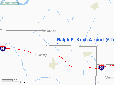
Location
& QuickFacts
|
FAA
Information Effective: |
2008-06-05 |
|
Airport
Identifier: |
61Y |
|
Airport
Status: |
Operational |
|
Longitude/Latitude: |
087-46-27.5830W/38-12-27.3030N
-87.774329/38.207584 (Estimated) |
|
Elevation: |
450 ft / 137.16 m (Estimated) |
|
Land: |
81 acres |
|
From nearest
city: |
2 nautical miles N of Poseyville, IN |
|
Location: |
Gibson County, IN |
|
Magnetic
Variation: |
05W (1990) |
Owner
& Manager
|
Ownership: |
Privately
owned |
|
Owner: |
Ralph E. Koch |
|
Address: |
11085 W. 1000 S.
Poseyville, IN 47633 |
|
Phone
number: |
812-874-3315 |
|
Manager: |
Ralph E. Koch |
|
Address: |
P.o. Box 503
Poseyville,
IN 47633 |
Airport
Operations and Facilities
|
Airport
Use: |
Open
to public |
|
Wind indicator: |
Yes |
|
Segmented
Circle: |
No |
|
Control
Tower: |
No |
|
Sectional
chart: |
St Louis |
|
Region: |
AGL - Great Lakes |
|
Boundary
ARTCC: |
ZID - Indianapolis |
|
Tie-in
FSS: |
HUF - Terre Haute |
|
FSS on
Airport: |
No |
|
FSS Toll
Free: |
1-800-WX-BRIEF |
|
NOTAMs
Facility: |
HUF (NOTAM-d service avaliable) |
Airport Communications
|
CTAF: |
122.700 |
|
Unicom: |
122.700
|
Airport Services
|
Runway Information
Runway 04/22
|
Dimension: |
2960 x 100 ft
/ 902.2 x 30.5 m |
|
Surface: |
TURF, |
|
|
Runway 04 |
Runway 22 |
|
Longitude: |
087-46-49.7000W |
087-46-20.3200W |
|
Latitude: |
38-12-07.9400N |
38-12-30.3300N |
|
Elevation: |
430.00 ft |
450.00 ft |
|
Traffic
Pattern: |
Left |
Left |
|
Displaced
threshold: |
0.00 ft |
922.00 ft |
|
Obstruction: |
, 50:1 slope to clear |
15 ft road
DSPLCD THLD 20:1; 71 FT TREES 1422 FT FM RY END. |
|
Runway 18U/36U
|
Dimension: |
1125 x 100 ft
/ 342.9 x 30.5 m |
|
Surface: |
TURF, |
|
|
Runway 18U |
Runway 36U |
|
Traffic
Pattern: |
Left |
Left |
|
Displaced
threshold: |
300.00 ft |
200.00 ft |
|
Obstruction: |
15 ft road |
10 ft crops |
|
Radio Navigation
Aids
|
ID |
Type |
Name |
Ch |
Freq |
Var |
Dist |
|
PDW |
NDB |
Evansville |
|
284.00 |
00E |
15.3 nm |
|
CUL |
NDB |
Carmi |
|
332.00 |
01W |
17.7 nm |
|
GVA |
NDB |
Geneva |
|
224.00 |
01W |
24.3 nm |
|
AJG |
NDB |
Mount Carmel |
|
524.00 |
02W |
24.4 nm |
|
OEA |
NDB |
Vincennes |
|
251.00 |
00E |
30.9 nm |
|
FWC |
NDB |
Wayne County |
|
257.00 |
01E |
31.7 nm |
|
OLY |
NDB |
Olney |
|
272.00 |
00W |
36.0 nm |
|
DCY |
NDB |
Washington |
|
212.00 |
03W |
42.1 nm |
|
FOA |
NDB |
Elm River |
|
353.00 |
00E |
42.3 nm |
|
HSB |
NDB |
Harrisburg-raleigh |
|
230.00 |
00E |
43.6 nm |
|
FNZ |
NDB |
Ferdinand |
|
239.00 |
00E |
44.3 nm |
|
TWT |
NDB |
Tradewater |
|
276.00 |
00E |
45.3 nm |
|
PLX |
NDB |
Palestine |
|
391.00 |
00W |
48.8 nm |
|
SAM |
VOR/DME |
Samsville |
113X |
116.60 |
03E |
22.2 nm |
|
LWV |
VOR/DME |
Lawrenceville |
025X |
108.80 |
01W |
34.7 nm |
|
HNB |
VOR/DME |
Huntingburg |
029X |
109.20 |
00E |
38.7 nm |
|
OWB |
VOR/DME |
Owensboro |
023X |
108.60 |
01E |
40.1 nm |
|
RSV |
VOR/DME |
Robinson |
021X |
108.40 |
02E |
49.1 nm |
|
VNN |
VOR/DME |
Mount Vernon |
085X |
113.80 |
02E |
49.6 nm |
|
PXV |
VORTAC |
Pocket City |
080X |
113.30 |
03E |
16.8 nm |
Remarks
- (A57-18)
DSPLCD THLD 20:1.
- (A57-36)
DSPLCD THLD 20:1.
- SEE
AIRSPACE CASE 98-AGL-463-NRA.
Based Aircraft
|
Aircraft
based on field: |
2 |
|
Single Engine
Airplanes: |
1 |
|
Ultralights: |
1 |
Operational Statistics
Time
Period: 2006-01-01 - 2006-12-31
|
Aircraft
Operations: |
17/Week |
|
General Aviation
Local: |
90.0% |
|
General Aviation
Itinerant: |
10.0% |
Ralph E. Koch Airport
Address:
Gibson County, IN
Tel:
812-874-3315
Images
and information placed above are from
http://www.airport-data.com/airport/61Y/
We
thank them for the data!
| General
Info |
| Country |
United
States |
| State |
INDIANA
|
| FAA ID |
61Y |
| Latitude |
38-12-27.303N
|
| Longitude |
087-46-27.583W
|
| Elevation |
450 feet
|
| Near City |
POSEYVILLE
|
We don't guarantee the information is fresh and accurate. The data may
be wrong or outdated.
For more up-to-date information please refer to other sources.
|
|


