|
|
|
 |
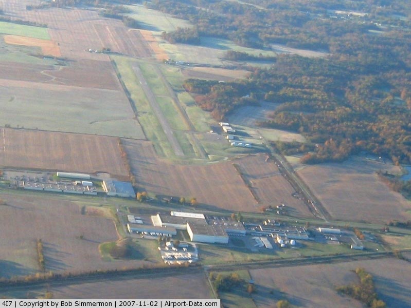
(Click on the photo to enlarge) |
|
 |
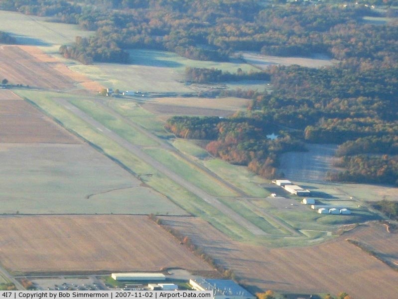
(Click on the photo to enlarge) |
Location
& QuickFacts
|
FAA
Information Effective: |
2008-06-05 |
|
Airport
Identifier: |
4I7 |
|
Airport
Status: |
Operational |
|
Longitude/Latitude: |
086-48-49.7000W/39-38-00.8000N
-86.813806/39.633556 (Estimated) |
|
Elevation: |
842 ft / 256.64 m (Surveyed) |
|
Land: |
192 acres |
|
From nearest
city: |
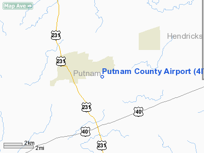
3 nautical miles SE of Greencastle, IN |
|
Location: |
Putnam County, IN |
|
Magnetic
Variation: |
03W (2005) |
Owner
& Manager
|
Ownership: |
Publicly
owned |
|
Owner: |
Putnam Co Boac |
|
Address: |
100 Balard Lane
Greencastle, IN 46135
JOHN STUGEON - PRESIDENT. |
|
Phone
number: |
765-653-1763 |
|
Manager: |
John Layne |
|
Address: |
100 Balard Lane
Greencastle,
IN 46135 |
|
Phone
number: |
765-653-1763
317-653-3893 |
Airport
Operations and Facilities
|
Airport
Use: |
Open
to public |
|
Wind indicator: |
Yes |
|
Segmented
Circle: |
No |
|
Control
Tower: |
No |
|
Lighting
Schedule: |
DUSK-DAWN
ACTVT LIRL RY 18/36 - CTAF. PCL OTS EXCEPT MED INTST KEY
CTAF 7 TIMES. |
|
Beacon
Color: |
Clear-Green (lighted land airport) |
|
Landing
fee charge: |
No |
|
Sectional
chart: |
St Louis |
|
Region: |
AGL - Great Lakes |
|
Traffic
Pattern Alt: |
1000 ft |
|
Boundary
ARTCC: |
ZID - Indianapolis |
|
Tie-in
FSS: |
HUF - Terre Haute |
|
FSS on
Airport: |
No |
|
FSS Toll
Free: |
1-800-WX-BRIEF |
|
NOTAMs
Facility: |
HUF (NOTAM-d service avaliable) |
|
Federal
Agreements: |
NGY |
Airport Communications
|
CTAF: |
122.800 |
|
Unicom: |
122.800
|
Airport
Services
|
Fuel
available: |
100LLA1+ |
|
Airframe
Repair: |
MAJOR |
|
Power
Plant Repair: |
MAJOR |
|
Runway Information
Runway 18/36
|
Dimension: |
4987 x 100 ft
/ 1520.0 x 30.5 m |
|
Surface: |
ASPH, Good Condition |
|
Edge Lights: |
Low |
|
|
Runway 18 |
Runway 36 |
|
Longitude: |
086-48-49.1257W |
086-48-50.3521W |
|
Latitude: |
39-38-25.4514N |
39-37-36.1814N |
|
Elevation: |
842.00 ft |
814.00 ft |
|
Alignment: |
127 |
1 |
|
Traffic
Pattern: |
Left |
Left |
|
Markings: |
Non-precision instrument, Good Condition |
Non-precision instrument, Good Condition |
|
Crossing
Height: |
20.00 ft |
30.00 ft |
|
VASI: |
4-light PAPI on left side |
4-light PAPI on left side |
|
Visual Glide
Angle: |
3.00° |
3.00° |
|
Runway End
Identifier: |
No |
No |
|
Centerline
Lights: |
No |
No |
|
Touchdown
Lights: |
No |
No |
|
Obstruction: |
10 ft crops, 330.0 ft from runway, 13:1 slope
to clear |
15 ft road, 764.0 ft from runway, 37:1 slope
to clear |
|
Radio Navigation
Aids
|
ID |
Type |
Name |
Ch |
Freq |
Var |
Dist |
|
TVX |
NDB |
Greencastle |
|
521.00 |
03W |
4.9 nm |
|
CFJ |
NDB |
Crawfordsville |
|
388.00 |
02W |
21.4 nm |
|
HU |
NDB |
Yinno |
|
245.00 |
02W |
30.8 nm |
|
HZP |
NDB |
Zionsville |
|
248.00 |
03W |
31.9 nm |
|
HFY |
NDB |
Greenwood |
|
398.00 |
02W |
33.5 nm |
|
BM |
NDB |
Claye |
|
382.00 |
02W |
36.1 nm |
|
UMP |
NDB |
Metropolitan |
|
338.00 |
03W |
39.7 nm |
|
FKR |
NDB |
Frankfort |
|
278.00 |
02W |
40.0 nm |
|
PRG |
NDB |
Paris |
|
341.00 |
01E |
40.0 nm |
|
SIV |
NDB |
Sullivan |
|
326.00 |
02W |
42.9 nm |
|
BA |
NDB |
Clifs |
|
410.00 |
03W |
49.8 nm |
|
TTH |
VORTAC |
Terre Haute |
100X |
115.30 |
02E |
22.0 nm |
|
VHP |
VORTAC |
Brickyard |
110X |
116.30 |
01E |
23.3 nm |
|
OOM |
VORTAC |
Hoosier |
039X |
110.20 |
02W |
30.9 nm |
|
SHB |
VORTAC |
Shelbyville |
057X |
112.00 |
01E |
45.8 nm |
|
IND |
VOT |
Indianapolis Intl |
|
109.60 |
|
25.1 nm |
Remarks
- DEER
ON & INVOF ARPT.
- 414
FT TWY S END OF RWY 36.
- EXISTED
PRIOR TO 1959.
Based Aircraft
|
Aircraft
based on field: |
33 |
|
Single Engine
Airplanes: |
20 |
|
Multi Engine Airplanes: |
4 |
|
Jet Engine Airplanes: |
1 |
|
Helicopters: |
3 |
|
Ultralights: |
5 |
Operational Statistics
Time
Period: 2004-04-01 - 2005-03-31
|
Aircraft
Operations: |
78/Day |
|
Air Taxi: |
10.0% |
|
General Aviation
Local: |
34.0% |
|
General Aviation
Itinerant: |
56.0% |
Putnam County Airport
Address:
Putnam County, IN
Tel:
765-653-1763,
317-653-3893
Images
and information placed above are from
http://www.airport-data.com/airport/4I7/
We
thank them for the data!
| General
Info |
| Country |
United
States |
| State |
INDIANA
|
| FAA ID |
4I7 |
| Latitude |
39-37-49.100N
|
| Longitude |
086-48-50.040W
|
| Elevation |
842 feet
|
| Near City |
GREENCASTLE
|
We don't guarantee the information is fresh and accurate. The data may
be wrong or outdated.
For more up-to-date information please refer to other sources.
|
|