 |
|
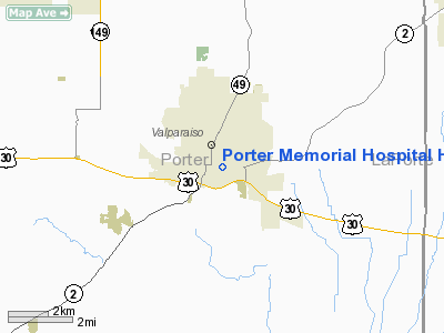
Porter Memorial Hospital Heliport |
Location
& QuickFacts
|
FAA
Information Effective: |
2008-06-05 |
|
Airport
Identifier: |
46II |
|
Airport
Status: |
Operational |
|
Longitude/Latitude: |
087-03-02.1070W/41-28-00.1410N
-87.050585/41.466706 (Estimated) |
|
Elevation: |
864 ft / 263.35 m (Estimated) |
|
Land: |
0 acres |
|
From nearest
city: |
2 nautical miles E of Valparaiso, IN |
|
Location: |
Porter County, IN |
|
Magnetic
Variation: |
01W (1985) |
Owner
& Manager
|
Ownership: |
Privately
owned |
|
Owner: |
Porter Memorial Hospital |
|
Address: |
814 La Porte Ave.
Valparaiso,
IN 46383 |
|
Phone
number: |
219-465-4600 |
|
Manager: |
Wiley N. Carr, Pres/ceo |
|
Address: |
814 La Porte Ave.
Valparaiso,
IN 46383 |
|
Phone
number: |
219-465-4600 |
Airport Operations
and Facilities
|
Airport
Use: |
Private
MEDICAL USE. |
|
Wind indicator: |
Yes |
|
Segmented
Circle: |
No |
|
Control
Tower: |
No |
|
Lighting
Schedule: |
DUSK-DAWN |
|
Beacon
Color: |
Clear-Green-Yellow (heliport) |
|
Sectional
chart: |
Chicago |
|
Region: |
AGL - Great Lakes |
|
Boundary
ARTCC: |
ZAU - Chicago |
|
Tie-in
FSS: |
HUF - Terre Haute |
|
FSS Toll
Free: |
1-800-WX-BRIEF |
|
Runway Information
Helipad H1
|
Dimension: |
40 x 40 ft /
12.2 x 12.2 m |
|
Surface: |
ALUM-DECK,
ROOFTOP. |
|
|
Runway H1 |
Runway |
|
Traffic
Pattern: |
Left |
Left |
|
Markings: |
Basic, |
, |
|
Radio Navigation
Aids
|
ID |
Type |
Name |
Ch |
Freq |
Var |
Dist |
|
VP |
NDB |
Sedly |
|
212.00 |
02W |
7.9 nm |
|
IUL |
NDB |
La Porte |
|
356.00 |
03W |
12.7 nm |
|
MGC |
NDB |
Michigan City |
|
203.00 |
01W |
17.9 nm |
|
RWN |
NDB |
Winamac/dcmsnd |
|
335.00 |
00W |
30.1 nm |
|
RZL |
NDB |
Rensselaer |
|
362.00 |
02W |
31.8 nm |
|
MX |
NDB |
Kedzi |
|
248.00 |
01W |
33.1 nm |
|
CPB |
NDB |
Culver |
|
391.00 |
01W |
33.6 nm |
|
HK |
NDB |
Ermin |
|
332.00 |
01W |
38.4 nm |
|
RCR |
NDB |
Rochester |
|
216.00 |
03W |
45.8 nm |
|
MCX |
NDB |
White County |
|
377.00 |
03W |
47.3 nm |
|
OXI |
VOR/DME |
Knox |
103X |
115.60 |
00E |
20.1 nm |
|
IKK |
VOR/DME |
Kankakee |
053X |
111.60 |
00E |
43.1 nm |
|
ORD |
VOR/DME |
Chicago O'hare |
086X |
113.90 |
02E |
49.5 nm |
|
CGT |
VORTAC |
Chicago Heights |
089X |
114.20 |
02E |
23.6 nm |
|
EON |
VORTAC |
Peotone |
079X |
113.20 |
02E |
35.4 nm |
|
GIJ |
VORTAC |
Gipper |
101X |
115.40 |
00E |
37.6 nm |
|
GSH |
VORTAC |
Goshen |
084X |
113.70 |
00E |
46.2 nm |
|
MDW |
VOT |
Chicago Midway |
|
111.00 |
|
36.9 nm |
|
ORD |
VOT |
Chicago O'hare Intl |
|
112.00 |
|
49.4 nm |
Remarks
- PRVDD
OPNS CONDUCTED IN AN AREA FROM 125 DEGREES TO 235 DEGREES; FM 315 DEGREES
TO 055 DEGREES; AREA IS MKD;WIND INDICATOR IS MAINTAINED.
Porter Memorial Hospital Heliport
Address:
Porter County, IN
Tel:
219-465-4600
Images
and information placed above are from
http://www.airport-data.com/airport/46II/
We
thank them for the data!
| General
Info |
| Country |
United
States |
| State |
INDIANA
|
| FAA ID |
46II |
| Latitude |
41-28-00.141N
|
| Longitude |
087-03-02.107W
|
| Elevation |
864 feet
|
| Near City |
VALPARAISO
|
We don't guarantee the information is fresh and accurate. The data may
be wrong or outdated.
For more up-to-date information please refer to other sources.
|
|


