 |
|
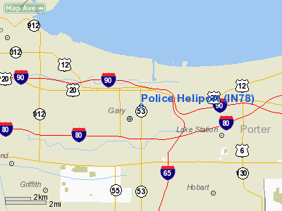
Location
& QuickFacts
|
FAA
Information Effective: |
2008-06-05 |
|
Airport
Identifier: |
IN78 |
|
Airport
Status: |
Operational |
|
Longitude/Latitude: |
087-20-10.1360W/41-35-28.1300N
-87.336149/41.591147 (Estimated) |
|
Elevation: |
591 ft / 180.14 m (Estimated) |
|
Land: |
0 acres |
|
From nearest
city: |
0 nautical miles N of Gary, IN |
|
Location: |
Lake County, IN |
|
Magnetic
Variation: |
01W (1985) |
Owner & Manager
|
Ownership: |
Privately
owned |
|
Owner: |
Gary Police Dept |
|
Address: |
1301 Broadway
Gary, IN 46406 |
|
Phone
number: |
219-881-1260 |
|
Manager: |
Clemmon Julkes |
|
Address: |
6051 Industrial Highway
Gary,
IN 46406 |
|
Phone
number: |
219-949-6294 |
Airport Operations
and Facilities
|
Airport Use: |
Private |
|
Wind
indicator: |
Yes |
|
Segmented
Circle: |
No |
|
Control
Tower: |
No |
|
Landing
fee charge: |
No |
|
Sectional
chart: |
Chicago |
|
Region: |
AGL - Great Lakes |
|
Boundary
ARTCC: |
ZAU - Chicago |
|
Tie-in
FSS: |
HUF - Terre Haute |
|
FSS on
Airport: |
No |
|
FSS Toll
Free: |
1-800-WX-BRIEF |
Airport Services
|
Airframe
Repair: |
NONE |
|
Power
Plant Repair: |
NONE |
|
Runway Information
Helipad H1
|
Dimension: |
319 x 125 ft
/ 97.2 x 38.1 m |
|
Surface: |
ASPH, |
|
|
Runway H1 |
Runway |
|
Traffic
Pattern: |
Left |
Left |
|
Radio Navigation
Aids
|
ID |
Type |
Name |
Ch |
Freq |
Var |
Dist |
|
MX |
NDB |
Kedzi |
|
248.00 |
01W |
18.3 nm |
|
VP |
NDB |
Sedly |
|
212.00 |
02W |
22.3 nm |
|
HK |
NDB |
Ermin |
|
332.00 |
01W |
23.7 nm |
|
MGC |
NDB |
Michigan City |
|
203.00 |
01W |
24.4 nm |
|
IUL |
NDB |
La Porte |
|
356.00 |
03W |
26.0 nm |
|
ME |
NDB |
Deana |
|
350.00 |
00E |
38.3 nm |
|
RZL |
NDB |
Rensselaer |
|
362.00 |
02W |
39.3 nm |
|
RWN |
NDB |
Winamac/dcmsnd |
|
335.00 |
00W |
44.5 nm |
|
CPB |
NDB |
Culver |
|
391.00 |
01W |
48.4 nm |
|
ORD |
VOR/DME |
Chicago O'hare |
086X |
113.90 |
02E |
34.9 nm |
|
OXI |
VOR/DME |
Knox |
103X |
115.60 |
00E |
34.9 nm |
|
IKK |
VOR/DME |
Kankakee |
053X |
111.60 |
00E |
38.8 nm |
|
OBK |
VOR/DME |
Northbrook |
077X |
113.00 |
02W |
46.8 nm |
|
DPA |
VOR/DME |
Dupage |
021X |
108.40 |
02E |
48.9 nm |
|
CGT |
VORTAC |
Chicago Heights |
089X |
114.20 |
02E |
11.7 nm |
|
EON |
VORTAC |
Peotone |
079X |
113.20 |
02E |
28.2 nm |
|
JOT |
VORTAC |
Joliet |
070X |
112.30 |
02E |
44.3 nm |
|
GIJ |
VORTAC |
Gipper |
101X |
115.40 |
00E |
46.9 nm |
|
MDW |
VOT |
Chicago Midway |
|
111.00 |
|
22.0 nm |
|
ORD |
VOT |
Chicago O'hare Intl |
|
112.00 |
|
34.8 nm |
Remarks
- MANY
POLICE CARS NEAR LANDING AREA-MARKED.
- INGRESS/EGRESS
ROUTES FROM RR TRACKS N OF SITE TO HELIPORT & FROM OVER POLICE HQ
S OF SITE TO HELIPORT.
Based Aircraft
|
Aircraft
based on field: |
3 |
|
Helicopters: |
3 |
Police Heliport
Address:
Lake County, IN
Tel:
219-881-1260,
219-949-6294
Images
and information placed above are from
http://www.airport-data.com/airport/IN78/
We
thank them for the data!
| General
Info |
| Country |
United
States |
| State |
INDIANA
|
| FAA ID |
IN78 |
| Latitude |
41-35-28.130N
|
| Longitude |
087-20-10.136W
|
| Elevation |
591 feet
|
| Near City |
GARY |
We don't guarantee the information is fresh and accurate. The data may
be wrong or outdated.
For more up-to-date information please refer to other sources.
|
|


