 |
|
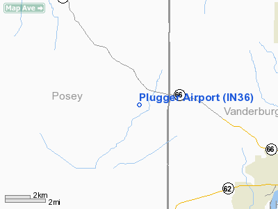
Location
& QuickFacts
|
FAA
Information Effective: |
2008-06-05 |
|
Airport
Identifier: |
IN36 |
|
Airport
Status: |
Operational |
|
Longitude/Latitude: |
087-43-26.8000W/38-02-08.0000N
-87.724111/38.035556 (Estimated) |
|
Elevation: |
426 ft / 129.84 m (Estimated) |
|
Land: |
0 acres |
|
From nearest
city: |
10 nautical miles NW of Evansville, IN |
|
Location: |
Posey County, IN |
|
Magnetic
Variation: |
() |
Owner
& Manager
|
Ownership: |
Privately
owned |
|
Owner: |
Donald Kuhlenschmidt |
|
Address: |
120 St. Philips Rd North
Evansville, IN 47712 |
|
Phone
number: |
812-985-2652 |
|
Manager: |
Donald Kuhlenschmidt |
|
Address: |
120 St. Philips Rd North
Evansville, IN 47712 |
|
Phone
number: |
812-985-2652 |
Airport Operations
and Facilities
|
Airport
Use: |
Private |
|
Wind indicator: |
Yes |
|
Segmented
Circle: |
No |
|
Control
Tower: |
No |
|
Sectional
chart: |
St Louis |
|
Region: |
AGL - Great Lakes |
|
Boundary
ARTCC: |
ZID - Indianapolis |
|
Tie-in
FSS: |
HUF - Terre Haute |
|
FSS Toll
Free: |
1-800-WX-BRIEF |
|
Runway Information
Runway 18/36
|
Dimension: |
2250 x 80 ft
/ 685.8 x 24.4 m |
|
Surface: |
TURF, |
|
|
Runway 18 |
Runway 36 |
|
Traffic
Pattern: |
Left |
Left |
|
Displaced
threshold: |
0.00 ft |
150.00 ft
RY 36 DSPLCD THLD MARKED WITH STRIPS OF COAL MINE CONVEYOR
BELT MEASURING 3 FT BY 15 FT. |
|
Obstruction: |
30 ft pline, 780.0 ft from runway |
40 ft trees, 650.0 ft from runway |
|
Radio Navigation
Aids
|
ID |
Type |
Name |
Ch |
Freq |
Var |
Dist |
|
PDW |
NDB |
Evansville |
|
284.00 |
00E |
9.1 nm |
|
GVA |
NDB |
Geneva |
|
224.00 |
01W |
14.1 nm |
|
CUL |
NDB |
Carmi |
|
332.00 |
01W |
19.0 nm |
|
AJG |
NDB |
Mount Carmel |
|
524.00 |
02W |
34.6 nm |
|
TWT |
NDB |
Tradewater |
|
276.00 |
00E |
35.8 nm |
|
FWC |
NDB |
Wayne County |
|
257.00 |
01E |
38.4 nm |
|
OEA |
NDB |
Vincennes |
|
251.00 |
00E |
40.2 nm |
|
HSB |
NDB |
Harrisburg-raleigh |
|
230.00 |
00E |
41.2 nm |
|
FNZ |
NDB |
Ferdinand |
|
239.00 |
00E |
43.8 nm |
|
OLY |
NDB |
Olney |
|
272.00 |
00W |
46.2 nm |
|
DCY |
NDB |
Washington |
|
212.00 |
03W |
48.5 nm |
|
TEL |
NDB |
Tell City |
|
206.00 |
02W |
49.0 nm |
|
OWB |
VOR/DME |
Owensboro |
023X |
108.60 |
01E |
31.8 nm |
|
SAM |
VOR/DME |
Samsville |
113X |
116.60 |
03E |
32.0 nm |
|
HNB |
VOR/DME |
Huntingburg |
029X |
109.20 |
00E |
38.5 nm |
|
LWV |
VOR/DME |
Lawrenceville |
025X |
108.80 |
01W |
44.5 nm |
|
PXV |
VORTAC |
Pocket City |
080X |
113.30 |
03E |
6.7 nm |
|
CCT |
VORTAC |
Central City |
035X |
109.80 |
01W |
45.0 nm |
Remarks
- PRVDD
RY 36 IS DISPLACED 150 FT; THE RY BE GRADED SO THAT THE DITCH RY 18
DOES NOT COMPROMISE THE RY SAFETY AREA; AND SPONSOR IS ADVISED THE ARPT
LIES WITHIN CLASS C AIRSPACE OF EVV ARPT.
Based Aircraft
|
Aircraft
based on field: |
2 |
|
Single Engine
Airplanes: |
2 |
Plugger Airport
Address:
Posey County, IN
Tel:
812-985-2652
Images
and information placed above are from
http://www.airport-data.com/airport/IN36/
We
thank them for the data!
We don't guarantee the information is fresh and accurate. The data may
be wrong or outdated.
For more up-to-date information please refer to other sources.
|
|


