 |
|
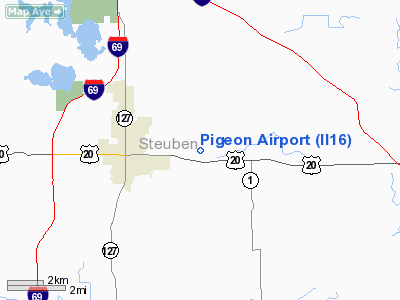
Location
& QuickFacts
|
FAA
Information Effective: |
2008-06-05 |
|
Airport
Identifier: |
II16 |
|
Airport
Status: |
Operational |
|
Longitude/Latitude: |
084-56-58.0000W/41-38-13.1810N
-84.949444/41.636995 (Estimated) |
|
Elevation: |
1000 ft / 304.80 m (Estimated) |
|
Land: |
0 acres |
|
From nearest
city: |
2 nautical miles E of Angola, IN |
|
Location: |
Steuben County, IN |
|
Magnetic
Variation: |
04W (1990) |
Owner
& Manager
|
Ownership: |
Privately
owned |
|
Owner: |
Lewis H Newman |
|
Address: |
P O Box 103
Angola,
IN 46703 |
|
Phone
number: |
219-665-3021 |
|
Address: |
|
Airport Operations
and Facilities
|
Airport
Use: |
Private |
|
Segmented
Circle: |
No |
|
Control
Tower: |
No |
|
Sectional
chart: |
Detroit |
|
Region: |
AGL - Great Lakes |
|
Boundary
ARTCC: |
ZOB - Cleveland |
|
Tie-in
FSS: |
HUF - Terre Haute |
|
FSS Toll
Free: |
1-800-WX-BRIEF |
|
Runway Information
Runway 13/31
|
Dimension: |
1800 x 100 ft
/ 548.6 x 30.5 m |
|
Surface: |
TURF, |
|
|
Runway 13 |
Runway 31 |
|
Traffic
Pattern: |
Left |
Left |
|
Radio Navigation
Aids
|
ID |
Type |
Name |
Ch |
Freq |
Var |
Dist |
|
ANQ |
NDB |
Angola |
|
347.00 |
05W |
6.2 nm |
|
BYN |
NDB |
Bryan |
|
260.00 |
04W |
23.7 nm |
|
IRS |
NDB |
Sturgis |
|
382.00 |
04W |
24.2 nm |
|
DFI |
NDB |
Defiance |
|
246.00 |
05W |
29.7 nm |
|
HAI |
NDB |
Three Rivers |
|
407.00 |
02W |
34.7 nm |
|
USE |
NDB |
Fulton |
|
375.00 |
05W |
36.7 nm |
|
ADG |
NDB |
Adrian |
|
278.00 |
06W |
41.5 nm |
|
BT |
NDB |
Batol |
|
272.00 |
04W |
44.8 nm |
|
VFU |
NDB |
Stanley |
|
411.00 |
05W |
49.0 nm |
|
OLK |
VOR |
Wolf Lake |
|
110.40 |
03W |
34.0 nm |
|
LFD |
VOR/DME |
Litchfield |
049X |
111.20 |
05W |
26.9 nm |
|
JXN |
VOR/DME |
Jackson |
033X |
109.60 |
05W |
43.4 nm |
|
AZO |
VOR/DME |
Kalamazoo |
027X |
109.00 |
01W |
45.0 nm |
|
FWA |
VORTAC |
Fort Wayne |
125X |
117.80 |
00E |
41.0 nm |
|
BTL |
VORTAC |
Battle Creek |
031X |
109.40 |
02W |
42.6 nm |
|
GSH |
VORTAC |
Goshen |
084X |
113.70 |
00E |
49.0 nm |
|
FWA |
VOT |
Fort Wayne Baer |
|
111.00 |
|
41.1 nm |
Remarks
- PROVIDED
125 FT EITHER SIDE OF CL AND 200 FT OFF RWY ENDS BE CLEAR OF OBST; OBST
IN APCH BE REMOVED/ LOWERED TO PROVIDE 20:1 CLNC.
Pigeon Airport
Address:
Steuben County, IN
Tel:
219-665-3021
Images
and information placed above are from
http://www.airport-data.com/airport/II16/
We
thank them for the data!
| General
Info |
| Country |
United
States |
| State |
INDIANA
|
| FAA ID |
II16 |
| Latitude |
41-38-13.181N
|
| Longitude |
084-56-58.000W
|
| Elevation |
1000 feet
|
| Near City |
ANGOLA
|
We don't guarantee the information is fresh and accurate. The data may
be wrong or outdated.
For more up-to-date information please refer to other sources.
|
|


