 |
|
|
|
|
|
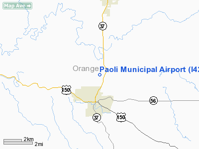
Location
& QuickFacts
|
FAA
Information Effective: |
2008-06-05 |
|
Airport
Identifier: |
I42 |
|
Airport
Status: |
Operational |
|
Longitude/Latitude: |
086-27-44.9560W/38-35-00.1970N
-86.462488/38.583388 (Estimated) |
|
Elevation: |
817 ft / 249.02 m (Surveyed) |
|
Land: |
210 acres |
|
From nearest
city: |
2 nautical miles N of Paoli, IN |
|
Location: |
Orange County, IN |
|
Magnetic
Variation: |
01W (1985) |
Owner & Manager
|
Ownership: |
Publicly
owned |
|
Owner: |
Paoli Boac |
|
Address: |
182 West Applegate
Paoli, IN 47454 |
|
Phone
number: |
812-723-9923 |
|
Manager: |
Glen Carmichael |
|
Address: |
182 West Applegate
Paoli, IN 47454 |
|
Phone
number: |
812-723-9923 |
Airport
Operations and Facilities
|
Airport
Use: |
Open
to public |
|
Wind indicator: |
Yes |
|
Segmented
Circle: |
No |
|
Control
Tower: |
No |
|
Lighting
Schedule: |
DUSK-DAWN
ACTVT MIRL RY 02/20 - CTAF. |
|
Beacon
Color: |
Clear-Green (lighted land airport) |
|
Landing
fee charge: |
No |
|
Sectional
chart: |
St Louis |
|
Region: |
AGL - Great Lakes |
|
Traffic
Pattern Alt: |
1600 ft |
|
Boundary
ARTCC: |
ZID - Indianapolis |
|
Tie-in
FSS: |
HUF - Terre Haute |
|
FSS on
Airport: |
No |
|
FSS Toll
Free: |
1-800-WX-BRIEF |
|
NOTAMs
Facility: |
HUF (NOTAM-d service avaliable) |
|
Federal
Agreements: |
NGY |
Airport Communications
|
CTAF: |
122.800 |
|
Unicom: |
122.800
|
Airport
Services
|
Fuel
available: |
100LL
FOR FUEL AFTER HOURS, CALL 812-723-4280, 812-723-4019, OR
812-723-3672. |
|
Airframe
Repair: |
MINOR |
|
Power
Plant Repair: |
MINOR |
|
Bottled
Oxygen: |
NONE |
|
Bulk Oxygen: |
NONE |
|
Runway Information
Runway 02/20
|
Dimension: |
2773 x 50 ft
/ 845.2 x 15.2 m |
|
Surface: |
ASPH, Good Condition |
|
Weight Limit: |
Single wheel: 7000 lbs. |
|
Edge Lights: |
Medium |
|
|
Runway 02 |
Runway 20 |
|
Longitude: |
086-27-58.9500W |
086-27-45.2300W |
|
Latitude: |
38-34-52.1900N |
38-35-21.9300N |
|
Elevation: |
810.00 ft |
802.00 ft |
|
Traffic
Pattern: |
Left |
Left |
|
Markings: |
Basic, Good Condition |
Basic, Good Condition |
|
Centerline
Lights: |
No |
No |
|
Touchdown
Lights: |
No |
No |
|
Obstruction: |
17 ft tree, 345.0 ft from runway, 100 ft right
of centerline, 8:1 slope to clear |
25 ft trees, 500.0 ft from runway, 125 ft right
of centerline, 12:1 slope to clear |
|
Radio Navigation
Aids
|
ID |
Type |
Name |
Ch |
Freq |
Var |
Dist |
|
RRJ |
NDB |
Oranj |
|
368.00 |
02W |
4.5 nm |
|
BFR |
NDB |
Bedford |
|
344.00 |
02W |
15.4 nm |
|
FNZ |
NDB |
Ferdinand |
|
239.00 |
00E |
26.8 nm |
|
EQZ |
NDB |
Captain |
|
308.00 |
02W |
28.6 nm |
|
BM |
NDB |
Claye |
|
382.00 |
02W |
29.1 nm |
|
DCY |
NDB |
Washington |
|
212.00 |
03W |
32.2 nm |
|
TEL |
NDB |
Tell City |
|
206.00 |
02W |
35.9 nm |
|
GOI |
NDB |
Godman |
|
396.00 |
02W |
44.0 nm |
|
IMS |
NDB |
Madison |
|
404.00 |
03W |
48.2 nm |
|
OVO |
NDB |
North Vernon |
|
374.00 |
02W |
49.1 nm |
|
MYS |
VOR |
Mystic |
|
108.20 |
01W |
42.7 nm |
|
HNB |
VOR/DME |
Huntingburg |
029X |
109.20 |
00E |
30.7 nm |
|
BQM |
VOR/DME |
Bowman |
059X |
112.20 |
01W |
43.2 nm |
|
FTK |
VOR/DME |
Fort Knox |
033X |
109.60 |
01W |
46.7 nm |
|
OOM |
VORTAC |
Hoosier |
039X |
110.20 |
02W |
34.4 nm |
|
ABB |
VORTAC |
Nabb |
071X |
112.40 |
01E |
38.8 nm |
|
SDF |
VOT |
Louisville Standifd |
|
111.00 |
|
42.0 nm |
Remarks
- SNOW
REMOVAL WINTER MONTHS.
- TERRIAN
DROPS 8 FT 55 FT WEST OF APCH END OF RY 20 & A 10 FT TERRIAN DROP
55 FT EAST OF RY CNTRLN AT CENTER OF RY.
- HELI
DTRMN: CONDL, ALL OPNS IN AREA TO/FM 80 DEG & 270-360 DEG, AREA
MKD, WIND INDCR MAINTD.
Based Aircraft
|
Aircraft
based on field: |
27 |
|
Single Engine
Airplanes: |
19 |
|
Multi Engine Airplanes: |
1 |
|
Helicopters: |
1 |
|
Ultralights: |
6 |
Operational Statistics
Time
Period: 2006-01-01 - 2006-12-31
|
Aircraft
Operations: |
48/Week |
|
General Aviation
Local: |
48.9% |
|
General Aviation
Itinerant: |
51.1% |
Paoli Municipal Airport
Address:
Orange County, IN
Tel:
812-723-9923
Images
and information placed above are from
http://www.airport-data.com/airport/I42/
We
thank them for the data!
| General
Info |
| Country |
United
States |
| State |
INDIANA
|
| FAA ID |
I42 |
| Latitude |
38-35-00.197N
|
| Longitude |
086-27-44.956W
|
| Elevation |
817 feet
|
| Near City |
PAOLI
|
We don't guarantee the information is fresh and accurate. The data may
be wrong or outdated.
For more up-to-date information please refer to other sources.
|
|


