 |
|
|
|
|
|
Location
& QuickFacts
|
FAA
Information Effective: |
2008-06-05 |
|
Airport
Identifier: |
78I |
|
Airport
Status: |
Operational |
|
Longitude/Latitude: |
086-41-24.7000W/39-30-02.7000N
-86.690194/39.500750 (Estimated) |
|
Elevation: |
795 ft / 242.32 m (Estimated) |
|
Land: |
150 acres |
|
From nearest
city: |
3 nautical miles SW of Eminence, IN |
|
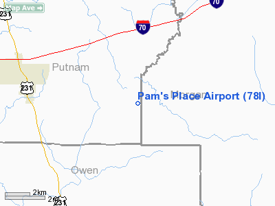
Location: |
Putnam County, IN |
|
Magnetic
Variation: |
02W (1990) |
Owner
& Manager
|
Ownership: |
Privately
owned |
|
Owner: |
Pam's Place Inc |
|
Address: |
13863 W. St Rd 42
Cloverdale, IN 46120 |
|
Phone
number: |
765-528-2235 |
|
Manager: |
Pamela S Patrick |
|
Address: |
13868 W. St Rd 42
Cloverdale, IN 46120 |
|
Phone
number: |
765-528-2660 |
Airport Operations
and Facilities
|
Airport
Use: |
Open
to public |
|
Wind indicator: |
Yes |
|
Segmented
Circle: |
Yes |
|
Control
Tower: |
No |
|
Sectional
chart: |
St Louis |
|
Region: |
AGL - Great Lakes |
|
Boundary
ARTCC: |
ZID - Indianapolis |
|
Tie-in
FSS: |
HUF - Terre Haute |
|
FSS Toll
Free: |
1-800-WX-BRIEF |
|
NOTAMs
Facility: |
HUF (NOTAM-d service avaliable) |
Airport Communications
Airport Services
|
Airframe
Repair: |
MAJOR |
|
Power
Plant Repair: |
MAJOR |
|
Runway Information
Runway 10/28
|
Dimension: |
3630 x 100 ft
/ 1106.4 x 30.5 m |
|
Surface: |
TURF, Good Condition |
|
|
Runway 10 |
Runway 28 |
|
Longitude: |
086-41-47.7200W |
086-41-01.7500W |
|
Latitude: |
39-30-04.9000N |
39-30-00.4800N |
|
Traffic
Pattern: |
Left |
Right |
|
Displaced
threshold: |
745.00 ft |
750.00 ft |
|
Obstruction: |
5 ft brush
RWY 10 APCH SLOPE 21:1 TO DSPLCD THLD; 63 FT TREES AT 600
FT. |
10 ft road, 5.0 ft from runway
APCH SLOPE TO DSPLCD THLD 20:1. 60
FT TREES AT 450 FT. |
|
Radio Navigation
Aids
|
ID |
Type |
Name |
Ch |
Freq |
Var |
Dist |
|
TVX |
NDB |
Greencastle |
|
521.00 |
03W |
13.9 nm |
|
BM |
NDB |
Claye |
|
382.00 |
02W |
27.0 nm |
|
HFY |
NDB |
Greenwood |
|
398.00 |
02W |
28.9 nm |
|
CFJ |
NDB |
Crawfordsville |
|
388.00 |
02W |
30.7 nm |
|
HZP |
NDB |
Zionsville |
|
248.00 |
03W |
33.3 nm |
|
HU |
NDB |
Yinno |
|
245.00 |
02W |
33.5 nm |
|
UMP |
NDB |
Metropolitan |
|
338.00 |
03W |
39.6 nm |
|
BFR |
NDB |
Bedford |
|
344.00 |
02W |
41.5 nm |
|
BA |
NDB |
Clifs |
|
410.00 |
03W |
41.9 nm |
|
SIV |
NDB |
Sullivan |
|
326.00 |
02W |
42.2 nm |
|
FKR |
NDB |
Frankfort |
|
278.00 |
02W |
46.6 nm |
|
PRG |
NDB |
Paris |
|
341.00 |
01E |
47.1 nm |
|
OOM |
VORTAC |
Hoosier |
039X |
110.20 |
02W |
21.8 nm |
|
VHP |
VORTAC |
Brickyard |
110X |
116.30 |
01E |
24.1 nm |
|
TTH |
VORTAC |
Terre Haute |
100X |
115.30 |
02E |
25.9 nm |
|
SHB |
VORTAC |
Shelbyville |
057X |
112.00 |
01E |
40.9 nm |
|
IND |
VOT |
Indianapolis Intl |
|
109.60 |
|
23.1 nm |
Remarks
- RY
10 TREES 75-150 FT EACH SIDE OF CNTRLN FOR 300 FT OF RY.
- DEER
& BIRDS ON & INVOF ARPT.
- PRVDD
ANY OBSTR REMOVED/LOWERED TO PROVIDE A CLEAR 20:1 APCH; AREA 125 FT
EITHER SIDE & 200 FT ENDS IS CLEAR; & THE AREA 60 FT EITHER
SIDE OF RY CNTRLN & 240 FT OFF RY ENDS HAVE NO RUTS OR HUMP OR HAZARDS.
Based Aircraft
|
Aircraft
based on field: |
12 |
|
Single Engine
Airplanes: |
11 |
|
Helicopters: |
1 |
Operational Statistics
Time
Period: 2004-09-14 - 2005-09-13
|
Aircraft
Operations: |
77/Week |
|
General Aviation
Local: |
91.6% |
|
General Aviation
Itinerant: |
8.4% |
Pam's Place Airport
Address:
Putnam County, IN
Tel:
765-528-2235,
765-528-2660
Images
and information placed above are from
http://www.airport-data.com/airport/78I/
We
thank them for the data!
| General
Info |
| Country |
United
States |
| State |
INDIANA
|
| FAA ID |
78I |
| Latitude |
39-30-03.000N
|
| Longitude |
086-41-31.000W
|
| Elevation |
795 feet
|
| Near City |
EMINENCE
|
We don't guarantee the information is fresh and accurate. The data may
be wrong or outdated.
For more up-to-date information please refer to other sources.
|
|


