 |
|
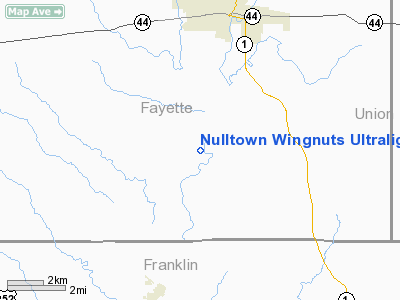
Nulltown Wingnuts Ultralight |
Location
& QuickFacts
|
FAA
Information Effective: |
2008-06-05 |
|
Airport
Identifier: |
73II |
|
Airport
Status: |
Operational |
|
Longitude/Latitude: |
085-09-31.0000W/39-34-18.0000N
-85.158611/39.571667 (Estimated) |
|
Elevation: |
765 ft / 233.17 m (Estimated) |
|
Land: |
0 acres |
|
From nearest
city: |
5 nautical miles S of Connersville, IN |
|
Location: |
Fayette County, IN |
|
Magnetic
Variation: |
03W (1990) |
Owner
& Manager
|
Ownership: |
Privately
owned |
|
Owner: |
Nulltown Wingnuts |
|
Address: |
Box 1025 W Cr 480s
Connersville, IN 47331 |
|
Phone
number: |
317-825-6898 |
|
Manager: |
Art Mahan |
|
Address: |
Box 1025 W Cr 480s
Connersville, IN 47331 |
|
Phone
number: |
317-825-6898 |
Airport Operations
and Facilities
|
Airport
Use: |
Private |
|
Wind indicator: |
Yes |
|
Segmented
Circle: |
No |
|
Control
Tower: |
No |
|
Sectional
chart: |
St Louis |
|
Region: |
AGL - Great Lakes |
|
Boundary
ARTCC: |
ZID - Indianapolis |
|
Tie-in
FSS: |
HUF - Terre Haute |
|
FSS on
Airport: |
No |
|
FSS Toll
Free: |
1-800-WX-BRIEF |
|
Runway Information
Runway NE/SW
|
Dimension: |
800 x 60 ft
/ 243.8 x 18.3 m |
|
Surface: |
TURF, |
|
|
Runway NE |
Runway SW |
|
Traffic
Pattern: |
Left |
Left |
|
Obstruction: |
|
60 ft trees, 800.0 ft from runway |
|
Radio Navigation
Aids
|
ID |
Type |
Name |
Ch |
Freq |
Var |
Dist |
|
HLB |
NDB |
Batesville |
|
254.00 |
02W |
14.1 nm |
|
OXD |
NDB |
Oxford |
|
282.00 |
04W |
17.9 nm |
|
UWL |
NDB |
New Castle |
|
385.00 |
02W |
20.0 nm |
|
HAO |
NDB |
Hamilton |
|
260.00 |
04W |
29.7 nm |
|
HKF |
NDB |
Hook Field |
|
239.00 |
04W |
33.3 nm |
|
AI |
NDB |
Video |
|
371.00 |
03W |
34.1 nm |
|
BA |
NDB |
Clifs |
|
410.00 |
03W |
34.1 nm |
|
UR |
NDB |
Burln |
|
321.00 |
04W |
36.3 nm |
|
OVO |
NDB |
North Vernon |
|
374.00 |
02W |
37.5 nm |
|
ISZ |
NDB |
Cincinnati-blue Ash |
|
388.00 |
04W |
40.6 nm |
|
MDE |
NDB |
Madeira |
|
379.00 |
04W |
42.8 nm |
|
HFY |
NDB |
Greenwood |
|
398.00 |
02W |
43.3 nm |
|
LUK |
NDB |
Cincinnati |
|
335.00 |
04W |
45.3 nm |
|
UMP |
NDB |
Metropolitan |
|
338.00 |
03W |
46.7 nm |
|
VES |
NDB |
Versailles |
|
356.00 |
04W |
48.1 nm |
|
MIE |
VOR/DME |
Muncie |
091X |
114.40 |
03W |
41.5 nm |
|
DQN |
VOR/DME |
Dayton |
092X |
114.50 |
01W |
44.2 nm |
|
RID |
VORTAC |
Richmond |
043X |
110.60 |
03W |
18.4 nm |
|
SHB |
VORTAC |
Shelbyville |
057X |
112.00 |
01E |
31.0 nm |
|
CVG |
VORTAC |
Cincinnati |
120X |
117.30 |
04W |
39.5 nm |
|
LUK |
VOT |
Cincinnati Muni/lunken |
|
108.40 |
|
44.6 nm |
|
DAY |
VOT |
Dayton J M Cox-day |
|
111.00 |
|
47.7 nm |
Nulltown Wingnuts Ultralight
Address:
Fayette County, IN
Tel:
317-825-6898
Images
and information placed above are from
http://www.airport-data.com/airport/73II/
We
thank them for the data!
| General
Info |
| Country |
United
States |
| State |
INDIANA
|
| FAA ID |
73II |
| Latitude |
39-34-18.000N
|
| Longitude |
085-09-31.000W
|
| Elevation |
765 feet
|
| Near City |
CONNERSVILLE
|
We don't guarantee the information is fresh and accurate. The data may
be wrong or outdated.
For more up-to-date information please refer to other sources.
|
|


