 |
|
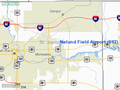
Location
& QuickFacts
|
FAA
Information Effective: |
2008-06-05 |
|
Airport
Identifier: |
9II2 |
|
Airport
Status: |
Operational |
|
Longitude/Latitude: |
086-09-18.0160W/41-41-15.1740N
-86.155004/41.687548 (Estimated) |
|
Elevation: |
750 ft / 228.60 m (Estimated) |
|
Land: |
10 acres |
|
From nearest
city: |
3 nautical miles NE of Mishawaka, IN |
|
Location: |
St Joseph County, IN |
|
Magnetic
Variation: |
03W (1985) |
Owner
& Manager
|
Ownership: |
Privately
owned |
|
Owner: |
Harold Nelund |
|
Address: |
503 E Colfax Avenue
South
Bend, IN 46617 |
|
Phone
number: |
219-232-4146 |
|
Address: |
|
|
Phone
number: |
219-255-4674 |
Airport
Operations and Facilities
|
Airport
Use: |
Private |
|
Wind indicator: |
Yes |
|
Segmented
Circle: |
No |
|
Control
Tower: |
No |
|
Sectional
chart: |
Chicago |
|
Region: |
AGL - Great Lakes |
|
Boundary
ARTCC: |
ZAU - Chicago |
|
Tie-in
FSS: |
HUF - Terre Haute |
|
FSS on
Airport: |
No |
|
FSS Toll
Free: |
1-800-WX-BRIEF |
|
Runway Information
Runway E/W
|
Dimension: |
1630 x 70 ft
/ 496.8 x 21.3 m |
|
Surface: |
TURF, |
|
|
Runway E |
Runway W |
|
Traffic
Pattern: |
Left |
Left |
|
Obstruction: |
35 ft pline |
50 ft trees, 100.0 ft from runway |
|
Radio Navigation
Aids
|
ID |
Type |
Name |
Ch |
Freq |
Var |
Dist |
|
MGC |
NDB |
Michigan City |
|
203.00 |
01W |
29.7 nm |
|
IUL |
NDB |
La Porte |
|
356.00 |
03W |
29.9 nm |
|
HAI |
NDB |
Three Rivers |
|
407.00 |
02W |
30.0 nm |
|
CPB |
NDB |
Culver |
|
391.00 |
01W |
30.1 nm |
|
IRS |
NDB |
Sturgis |
|
382.00 |
04W |
33.2 nm |
|
VP |
NDB |
Sedly |
|
212.00 |
02W |
35.5 nm |
|
RCR |
NDB |
Rochester |
|
216.00 |
03W |
37.5 nm |
|
RWN |
NDB |
Winamac/dcmsnd |
|
335.00 |
00W |
41.0 nm |
|
ANQ |
NDB |
Angola |
|
347.00 |
05W |
48.0 nm |
|
OLK |
VOR |
Wolf Lake |
|
110.40 |
03W |
39.7 nm |
|
ELX |
VOR/DME |
Keeler |
113X |
116.60 |
00E |
27.5 nm |
|
OXI |
VOR/DME |
Knox |
103X |
115.60 |
00E |
31.3 nm |
|
AZO |
VOR/DME |
Kalamazoo |
027X |
109.00 |
01W |
42.6 nm |
|
PMM |
VOR/DME |
Pullman |
058X |
112.10 |
00E |
46.8 nm |
|
GIJ |
VORTAC |
Gipper |
101X |
115.40 |
00E |
8.8 nm |
|
GSH |
VORTAC |
Goshen |
084X |
113.70 |
00E |
11.3 nm |
Remarks
- PRVDD
OBSTNS ARE RMVD/LWRD OR THRS DSPLCD TO PRVD 20:1 SLOPE.
Based Aircraft
|
Aircraft
based on field: |
1 |
|
Single Engine
Airplanes: |
1 |
Nelund Field Airport
Address:
St Joseph County, IN
Tel:
219-232-4146,
219-255-4674
Images
and information placed above are from
http://www.airport-data.com/airport/9II2/
We
thank them for the data!
| General
Info |
| Country |
United
States |
| State |
INDIANA
|
| FAA ID |
9II2 |
| Latitude |
41-41-15.174N
|
| Longitude |
086-09-18.016W
|
| Elevation |
750 feet
|
| Near City |
MISHAWAKA
|
We don't guarantee the information is fresh and accurate. The data may
be wrong or outdated.
For more up-to-date information please refer to other sources.
|
|


