 |
|
Location
& QuickFacts
|
FAA
Information Effective: |
2008-06-05 |
|
Airport
Identifier: |
70II |
|
Airport
Status: |
Operational |
|
Longitude/Latitude: |
085-41-10.9160W/39-31-18.1730N
-85.686366/39.521715 (Estimated) |
|
Elevation: |
830 ft / 252.98 m (Estimated) |
|
Land: |
0 acres |
|
From nearest
city: |
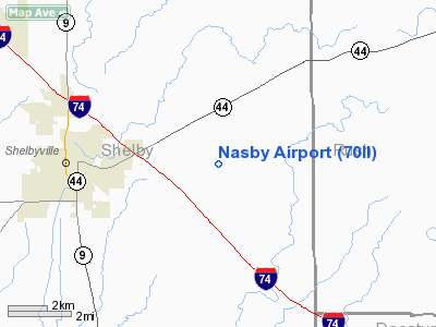
4 nautical miles E of Shelbyville, IN |
|
Location: |
Shelby County, IN |
|
Magnetic
Variation: |
03W (1990) |
Owner
& Manager
|
Ownership: |
Privately
owned |
|
Owner: |
Clifford & Kermit Nasby |
|
Address: |
4894 E Blue Ridge Rd.
Shelbyville,
IN 46176 |
|
Phone
number: |
317-392-1904 |
|
Manager: |
Clifford & Kermit Nasby |
|
Address: |
4894 E Blue Ridge Rd.
Shelbyville,
IN 46176 |
|
Phone
number: |
317-392-1904 |
Airport Operations
and Facilities
|
Airport
Use: |
Private |
|
Segmented
Circle: |
No |
|
Control
Tower: |
No |
|
Sectional
chart: |
St Louis |
|
Region: |
AGL - Great Lakes |
|
Boundary
ARTCC: |
ZID - Indianapolis |
|
Tie-in
FSS: |
HUF - Terre Haute |
|
FSS Toll
Free: |
1-800-WX-BRIEF |
|
Runway Information
Runway 09/27
|
Dimension: |
1500 x 80 ft
/ 457.2 x 24.4 m |
|
Surface: |
TURF, |
|
|
Runway 09 |
Runway 27 |
|
Traffic
Pattern: |
Left |
Left |
|
Displaced
threshold: |
80.00 ft |
80.00 ft |
|
Obstruction: |
|
4 ft fence |
|
Radio Navigation
Aids
|
ID |
Type |
Name |
Ch |
Freq |
Var |
Dist |
|
BA |
NDB |
Clifs |
|
410.00 |
03W |
13.5 nm |
|
HFY |
NDB |
Greenwood |
|
398.00 |
02W |
19.9 nm |
|
HLB |
NDB |
Batesville |
|
254.00 |
02W |
22.4 nm |
|
UWL |
NDB |
New Castle |
|
385.00 |
02W |
27.4 nm |
|
OVO |
NDB |
North Vernon |
|
374.00 |
02W |
28.6 nm |
|
UMP |
NDB |
Metropolitan |
|
338.00 |
03W |
30.1 nm |
|
AI |
NDB |
Video |
|
371.00 |
03W |
33.9 nm |
|
HZP |
NDB |
Zionsville |
|
248.00 |
03W |
36.2 nm |
|
EQZ |
NDB |
Captain |
|
308.00 |
02W |
41.5 nm |
|
OXD |
NDB |
Oxford |
|
282.00 |
04W |
42.0 nm |
|
IMS |
NDB |
Madison |
|
404.00 |
03W |
46.9 nm |
|
MIE |
VOR/DME |
Muncie |
091X |
114.40 |
03W |
45.1 nm |
|
SHB |
VORTAC |
Shelbyville |
057X |
112.00 |
01E |
9.2 nm |
|
VHP |
VORTAC |
Brickyard |
110X |
116.30 |
01E |
36.1 nm |
|
RID |
VORTAC |
Richmond |
043X |
110.60 |
03W |
41.7 nm |
|
OOM |
VORTAC |
Hoosier |
039X |
110.20 |
02W |
48.7 nm |
|
IND |
VOT |
Indianapolis Intl |
|
109.60 |
|
30.2 nm |
Remarks
- OBSTNS
REMOVED/LOWERED OR THRS DSPLCD TO PROVIDE 20:1 APCH SLOPE; AREA 125
FT EITHER SIDE OF CNTRLN & 200 FT EITHER END BE CLEAR OF OBSTNS.
Nasby Airport
Address:
Shelby County, IN
Tel:
317-392-1904
Images
and information placed above are from
http://www.airport-data.com/airport/70II/
We
thank them for the data!
| General
Info |
| Country |
United
States |
| State |
INDIANA
|
| FAA ID |
70II |
| Latitude |
39-31-18.173N
|
| Longitude |
085-41-10.916W
|
| Elevation |
830 feet
|
| Near City |
SHELBYVILLE
|
We don't guarantee the information is fresh and accurate. The data may
be wrong or outdated.
For more up-to-date information please refer to other sources.
|
|


