Mississinewa Reservoir Landing Area Seaplane Base |
Location
& QuickFacts
|
FAA
Information Effective: |
2008-06-05 |
|
Airport
Identifier: |
43I |
|
Airport
Status: |
Closed Indefinitely |
|
Longitude/Latitude: |
085-55-56.9570W/40-42-13.1500N
-85.932488/40.703653 (Estimated) |
|
Elevation: |
737 ft / 224.64 m (Estimated) |
|
Land: |
332 acres |
|
From nearest
city: |
6 nautical miles SE of Peru, IN |
|
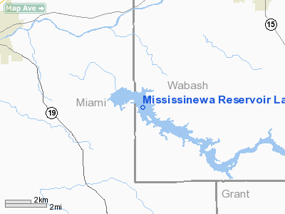
Location: |
Wabash County, IN |
|
Magnetic
Variation: |
03W (1985) |
Owner & Manager
|
Ownership: |
Publicly
owned |
|
Owner: |
Dept Of Natural Resources |
|
Address: |
4673 S. 625 E.
Peru, IN 46970 |
|
Phone
number: |
765-473-6528 |
|
Manager: |
Larry Brown |
|
Address: |
4673 S. 625 E.
Peru, IN 46970 |
|
Phone
number: |
765-473-6528 |
Airport
Operations and Facilities
|
Airport
Use: |
Open
to public |
|
Segmented
Circle: |
No |
|
Control
Tower: |
No |
|
Sectional
chart: |
Chicago |
|
Region: |
AGL - Great Lakes |
|
Boundary
ARTCC: |
ZAU - Chicago |
|
Tie-in
FSS: |
HUF - Terre Haute |
|
FSS on
Airport: |
No |
|
FSS Toll
Free: |
1-800-WX-BRIEF |
|
NOTAMs
Facility: |
HUF (NOTAM-d service avaliable) |
Airport
Communications
|
Runway Information
Runway NW/SE
|
Dimension: |
14500 x 1000
ft / 4419.6 x 304.8 m |
|
Surface: |
WATER, Good Condition |
|
|
Runway NW |
Runway SE |
|
Traffic
Pattern: |
Left |
Left |
|
Radio Navigation
Aids
|
ID |
Type |
Name |
Ch |
Freq |
Var |
Dist |
|
IWH |
NDB |
Wabash |
|
329.00 |
03W |
7.1 nm |
|
GGP |
NDB |
Logansport |
|
263.00 |
01W |
20.1 nm |
|
HHG |
NDB |
Huntington |
|
417.00 |
03W |
23.2 nm |
|
RCR |
NDB |
Rochester |
|
216.00 |
03W |
24.7 nm |
|
CPB |
NDB |
Culver |
|
391.00 |
01W |
37.0 nm |
|
MCX |
NDB |
White County |
|
377.00 |
03W |
37.8 nm |
|
RWN |
NDB |
Winamac/dcmsnd |
|
335.00 |
00W |
38.5 nm |
|
FKR |
NDB |
Frankfort |
|
278.00 |
02W |
38.8 nm |
|
AI |
NDB |
Video |
|
371.00 |
03W |
42.7 nm |
|
PLD |
NDB |
Portland |
|
257.00 |
03W |
45.9 nm |
|
UMP |
NDB |
Metropolitan |
|
338.00 |
03W |
46.4 nm |
|
HZP |
NDB |
Zionsville |
|
248.00 |
03W |
48.2 nm |
|
OLK |
VOR |
Wolf Lake |
|
110.40 |
03W |
38.2 nm |
|
MZZ |
VOR/DME |
Marion |
023X |
108.60 |
03W |
17.1 nm |
|
MIE |
VOR/DME |
Muncie |
091X |
114.40 |
03W |
37.3 nm |
|
OXI |
VOR/DME |
Knox |
103X |
115.60 |
00E |
49.4 nm |
|
GUS |
VORTAC |
Grissom |
21Y |
108.45 |
02W |
10.6 nm |
|
OKK |
VORTAC |
Kokomo |
082X |
113.50 |
00E |
12.0 nm |
|
FWA |
VORTAC |
Fort Wayne |
125X |
117.80 |
00E |
37.7 nm |
|
GSH |
VORTAC |
Goshen |
084X |
113.70 |
00E |
49.6 nm |
|
FWA |
VOT |
Fort Wayne Baer |
|
111.00 |
|
37.5 nm |
Remarks
- SEAPLANE
OPNS PROHIBITED BETWEEN SS & SR.
- INGRESS/EGRESS
SHD BE COORDD WITH GRISSOM AFB APP CTL 120.0.
- (ARPT
STATUS) ARPT CLSD INDEFLY.
Operational Statistics
Time
Period: 2006-01-01 - 2006-12-31
|
Aircraft
Operations: |
1/Month |
|
General Aviation
Itinerant: |
100.0% |
Mississinewa Reservoir Landing Area Seaplane
Base
Address:
Wabash County, IN
Tel:
765-473-6528
Images
and information placed above are from
http://www.airport-data.com/airport/43I/
We
thank them for the data!
| General
Info |
| Country |
United
States |
| State |
INDIANA
|
| FAA ID |
43I |
| Latitude |
40-42-13.150N
|
| Longitude |
085-55-56.957W
|
| Elevation |
737 feet
|
| Near City |
PERU |
We don't guarantee the information is fresh and accurate. The data may
be wrong or outdated.
For more up-to-date information please refer to other sources.
|


