 |
|
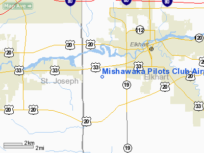
Mishawaka Pilots Club Airport |
|
|
Location
& QuickFacts
|
FAA
Information Effective: |
2008-06-05 |
|
Airport
Identifier: |
3C1 |
|
Airport
Status: |
Operational |
|
Longitude/Latitude: |
086-02-05.0060W/41-39-25.1750N
-86.034724/41.656993 (Estimated) |
|
Elevation: |
755 ft / 230.12 m (Estimated) |
|
Land: |
69 acres |
|
From nearest
city: |
3 nautical miles SW of Elkhart, IN |
|
Location: |
Elkhart County, IN |
|
Magnetic
Variation: |
03W (1985) |
Owner & Manager
|
Ownership: |
Privately
owned |
|
Owner: |
Airport Reality Board |
|
Address: |
Box 149
Osceola,
IN 46561 |
|
Phone
number: |
574-294-6943 |
|
Manager: |
Tom May |
|
Address: |
Box 149
Osleola,
IN 46561 |
|
Phone
number: |
574-849-3394 |
Airport
Operations and Facilities
|
Airport
Use: |
Open
to public |
|
Wind indicator: |
Yes |
|
Segmented
Circle: |
No |
|
Control
Tower: |
No |
|
Lighting
Schedule: |
DUSK-DAWN |
|
Beacon
Color: |
Clear-Green (lighted land airport) |
|
Landing
fee charge: |
No |
|
Sectional
chart: |
Chicago |
|
Region: |
AGL - Great Lakes |
|
Boundary
ARTCC: |
ZAU - Chicago |
|
Tie-in
FSS: |
HUF - Terre Haute |
|
FSS on
Airport: |
No |
|
FSS Toll
Free: |
1-800-WX-BRIEF |
|
NOTAMs
Facility: |
HUF (NOTAM-d service avaliable) |
Airport Communications
Airport Services
|
Airframe
Repair: |
NONE |
|
Power
Plant Repair: |
NONE |
|
Bottled
Oxygen: |
NONE |
|
Bulk Oxygen: |
NONE |
|
Runway Information
Runway 03/21
|
Dimension: |
2243 x 40 ft
/ 683.7 x 12.2 m |
|
Surface: |
ASPH, Fair Condition |
|
Edge Lights: |
Low |
|
|
Runway 03 |
Runway 21 |
|
Longitude: |
086-02-12.0000W |
086-01-56.9900W |
|
Latitude: |
41-39-10.0000N |
41-39-33.0900N |
|
Elevation: |
755.00 ft |
750.00 ft |
|
Traffic
Pattern: |
Left |
Left |
|
Markings: |
Basic, Good Condition |
Basic, Good Condition |
|
Displaced
threshold: |
187.00 ft |
200.00 ft |
|
Runway End
Identifier: |
No |
No |
|
Centerline
Lights: |
No |
No |
|
Touchdown
Lights: |
No |
No |
|
Obstruction: |
15 ft road, 240.0 ft from runway, 125 ft right
of centerline, 2:1 slope to clear
APCH RATIO 28:1 AT DSPLCD THR; ROAD. |
15 ft road, 242.0 ft from runway, 125 ft right
of centerline, 2:1 slope to clear
APCH RATIO 29:1 AT DSPLCD THR; ROAD. |
|
Runway 12/30
|
Dimension: |
3140 x 100 ft
/ 957.1 x 30.5 m |
|
Surface: |
TURF, Fair Condition |
|
|
Runway 12 |
Runway 30 |
|
Longitude: |
086-02-19.2100W |
086-01-51.0000W |
|
Latitude: |
41-39-29.9700N |
41-39-18.0000N |
|
Elevation: |
752.00 ft |
753.00 ft |
|
Traffic
Pattern: |
Left |
Left |
|
Markings: |
None,
RY 12/30 DSPLCD THLDS MKD WITH WHITE TIRES. |
None, |
|
Displaced
threshold: |
690.00 ft |
520.00 ft |
|
Runway End
Identifier: |
No |
No |
|
Centerline
Lights: |
No |
No |
|
Touchdown
Lights: |
No |
No |
|
Obstruction: |
50 ft trees, 600.0 ft from runway, 110 ft right
of centerline, 12:1 slope to clear
APCH RATIO 25:1 AT DSPLCD THR; 50 FT TREES 1290 FT FM THLD. |
71 ft trees, 900.0 ft from runway, 12:1 slope
to clear
APCH RATIO 20:1 ATDSPLCD THR. |
|
Radio Navigation
Aids
|
ID |
Type |
Name |
Ch |
Freq |
Var |
Dist |
|
HAI |
NDB |
Three Rivers |
|
407.00 |
02W |
26.9 nm |
|
IRS |
NDB |
Sturgis |
|
382.00 |
04W |
28.5 nm |
|
CPB |
NDB |
Culver |
|
391.00 |
01W |
30.8 nm |
|
IUL |
NDB |
La Porte |
|
356.00 |
03W |
34.5 nm |
|
MGC |
NDB |
Michigan City |
|
203.00 |
01W |
35.2 nm |
|
RCR |
NDB |
Rochester |
|
216.00 |
03W |
36.3 nm |
|
VP |
NDB |
Sedly |
|
212.00 |
02W |
39.9 nm |
|
RWN |
NDB |
Winamac/dcmsnd |
|
335.00 |
00W |
42.5 nm |
|
ANQ |
NDB |
Angola |
|
347.00 |
05W |
42.6 nm |
|
OLK |
VOR |
Wolf Lake |
|
110.40 |
03W |
34.5 nm |
|
ELX |
VOR/DME |
Keeler |
113X |
116.60 |
00E |
29.6 nm |
|
OXI |
VOR/DME |
Knox |
103X |
115.60 |
00E |
34.2 nm |
|
AZO |
VOR/DME |
Kalamazoo |
027X |
109.00 |
01W |
41.0 nm |
|
PMM |
VOR/DME |
Pullman |
058X |
112.10 |
00E |
48.7 nm |
|
GSH |
VORTAC |
Goshen |
084X |
113.70 |
00E |
7.9 nm |
|
GIJ |
VORTAC |
Gipper |
101X |
115.40 |
00E |
14.4 nm |
Remarks
Based Aircraft
|
Aircraft
based on field: |
62 |
|
Single Engine
Airplanes: |
57 |
|
Multi Engine Airplanes: |
3 |
|
Helicopters: |
2 |
Operational Statistics
Time
Period: 2004-01-02 - 2004-12-31
|
Aircraft
Operations: |
72/Day |
|
General Aviation
Local: |
83.1% |
|
General Aviation
Itinerant: |
16.9% |
Mishawaka Pilots Club Airport
Address:
Elkhart County, IN
Tel:
574-294-6943,
574-849-3394
Images
and information placed above are from
http://www.airport-data.com/airport/3C1/
We
thank them for the data!
| General
Info |
| Country |
United
States |
| State |
INDIANA
|
| FAA ID |
3C1 |
| Latitude |
41-39-25.175N
|
| Longitude |
086-02-05.006W
|
| Elevation |
755 feet
|
| Near City |
ELKHART
|
We don't guarantee the information is fresh and accurate. The data may
be wrong or outdated.
For more up-to-date information please refer to other sources.
|
|


