 |
|
| Miller Airport |
| IATA: none – ICAO: none – FAA LID: C40 |
| Summary |
| Airport type |
Public |
| Owner |
John W. Miller |
| Serves |
Bluffton, Indiana |
| Elevation AMSL |
845 ft / 258 m |
| Coordinates |
40°42′52″N 85°14′56″W / 40.71444°N 85.24889°W / 40.71444; -85.24889Coordinates: 40°42′52″N 85°14′56″W / 40.71444°N 85.24889°W / 40.71444; -85.24889 |
| Runways |
| Direction |
Length |
Surface |
| ft |
m |
| 9/27 |
2,600 |
792 |
Turf |
| 18/36 |
2,230 |
680 |
Turf |
| Statistics (2006) |
| Aircraft operations |
2,616 |
| Source: Federal Aviation Administration |
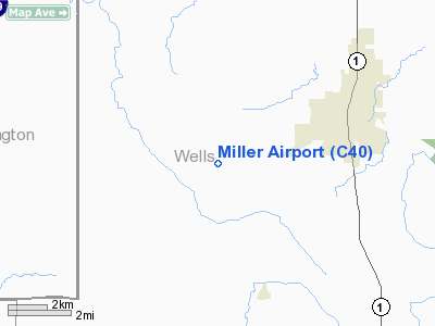
Miller Airport (FAA LID: C40) is a privately-owned, public-use airport located three nautical miles (6 km) southwest of the central business district of Bluffton, in Wells County, Indiana, United States.
Facilities and aircraft
Miller Airport covers an area of 80 acres (32 ha) at an elevation of 845 feet (258 m) above mean sea level. It has two runways with turf surfaces: 9/27 is 2,600 by 100 feet (792 × 30 m) and 18/36 is 2,230 by 100 feet (680 × 30 m). For the 12-month period ending December 31, 2006, the airport had 2,616 general aviation aircraft operations, an average of 218 per month.
The above content comes from Wikipedia and is published under free licenses – click here to read more.
Location
& QuickFacts
|
FAA
Information Effective: |
2008-06-05 |
|
Airport
Identifier: |
C40 |
|
Airport
Status: |
Operational |
|
Longitude/Latitude: |
085-14-59.8950W/40-43-00.1680N
-85.249971/40.716713 (Estimated) |
|
Elevation: |
845 ft / 257.56 m (Estimated) |
|
Land: |
80 acres |
|
From nearest
city: |
3 nautical miles SW of Bluffton, IN |
|
Location: |
Wells County, IN |
|
Magnetic
Variation: |
03W (1985) |
Owner
& Manager
|
Ownership: |
Privately
owned |
|
Owner: |
John W. Miller |
|
Address: |
1447 W 200 S, Airport Road
Bluffton, IN 46714 |
|
Phone
number: |
260-694-6710 |
|
Manager: |
John W. Miller |
|
Address: |
1447 W 200 S, Airport Road
Bluffton, IN 46714 |
|
Phone
number: |
260-694-6214 |
Airport Operations
and Facilities
|
Airport
Use: |
Open
to public |
|
Wind indicator: |
Yes |
|
Segmented
Circle: |
No |
|
Control
Tower: |
No |
|
Lighting
Schedule: |
DUSK-0000 |
|
Beacon
Color: |
Clear-Green (lighted land airport) |
|
Landing
fee charge: |
No |
|
Sectional
chart: |
Chicago |
|
Region: |
AGL - Great Lakes |
|
Boundary
ARTCC: |
ZAU - Chicago |
|
Tie-in
FSS: |
HUF - Terre Haute |
|
FSS on
Airport: |
No |
|
FSS Toll
Free: |
1-800-WX-BRIEF |
|
NOTAMs
Facility: |
HUF (NOTAM-d service avaliable) |
Airport Communications
Airport Services
|
Fuel
available: |
100LL |
|
Airframe
Repair: |
MAJOR |
|
Power
Plant Repair: |
MAJOR |
|
Bottled
Oxygen: |
NONE |
|
Bulk Oxygen: |
NONE |
|
Runway Information
Runway 09/27
|
Dimension: |
2600 x 100 ft
/ 792.5 x 30.5 m |
|
Surface: |
TURF, Fair Condition
SLIGHT ROLLING TERRAIN APRX MID-FLD. |
|
|
Runway 09 |
Runway 27 |
|
Longitude: |
085-15-02.5400W |
085-14-28.5800W |
|
Latitude: |
40-42-51.7100N |
40-42-51.7100N |
|
Elevation: |
843.00 ft |
845.00 ft |
|
Traffic
Pattern: |
Left |
Left |
|
Markings: |
None, |
None, |
|
Displaced
threshold: |
200.00 ft
RY 09/27 DSPLCD THLDS MKD WITH WHT CONES. |
300.00 ft |
|
Runway End
Identifier: |
No |
No |
|
Centerline
Lights: |
No |
No |
|
Touchdown
Lights: |
No |
No |
|
Obstruction: |
10 ft crops
RY 09 APCH RATIO 20:1 AT DSPLCD THR. |
15 ft road, 10.0 ft from runway
APCH RATIO 20:1 AT DSPLCD THR. |
|
Runway 18/36
|
Dimension: |
2230 x 100 ft
/ 679.7 x 30.5 m |
|
Surface: |
TURF, Fair Condition
SLIGHT ROLLING TERRAIN APRX MID-FLD. |
|
|
Runway 18 |
Runway 36 |
|
Longitude: |
085-14-56.8900W |
085-14-56.8900W |
|
Latitude: |
40-43-11.0300N |
40-42-45.3400N |
|
Elevation: |
841.00 ft |
845.00 ft |
|
Traffic
Pattern: |
Left |
Left |
|
Markings: |
None, |
None, |
|
Displaced
threshold: |
202.00 ft
RY 18/36 DSPLCD THLDS MKD WITH WHT CONES. |
261.00 ft |
|
Runway End
Identifier: |
No |
No |
|
Centerline
Lights: |
No |
No |
|
Touchdown
Lights: |
No |
No |
|
Obstruction: |
10 ft crops
RY 18 APCH RATIO 20:1 AT DSPLCD THR. |
22 ft bldg, 10.0 ft from runway, 90 ft left
of centerline
RY 36 APCH RATIO 11:1 AT DSPLCD THR. |
|
Radio Navigation
Aids
|
ID |
Type |
Name |
Ch |
Freq |
Var |
Dist |
|
HHG |
NDB |
Huntington |
|
417.00 |
03W |
12.8 nm |
|
PLD |
NDB |
Portland |
|
257.00 |
03W |
19.9 nm |
|
IWH |
NDB |
Wabash |
|
329.00 |
03W |
25.1 nm |
|
VFU |
NDB |
Stanley |
|
411.00 |
05W |
30.2 nm |
|
CQA |
NDB |
Lakefield |
|
205.00 |
04W |
34.3 nm |
|
AI |
NDB |
Video |
|
371.00 |
03W |
40.7 nm |
|
VES |
NDB |
Versailles |
|
356.00 |
04W |
45.3 nm |
|
RCR |
NDB |
Rochester |
|
216.00 |
03W |
47.6 nm |
|
OLK |
VOR |
Wolf Lake |
|
110.40 |
03W |
33.8 nm |
|
MZZ |
VOR/DME |
Marion |
023X |
108.60 |
03W |
23.7 nm |
|
MIE |
VOR/DME |
Muncie |
091X |
114.40 |
03W |
29.6 nm |
|
FWA |
VORTAC |
Fort Wayne |
125X |
117.80 |
00E |
16.0 nm |
|
OKK |
VORTAC |
Kokomo |
082X |
113.50 |
00E |
38.6 nm |
|
GUS |
VORTAC |
Grissom |
21Y |
108.45 |
02W |
41.3 nm |
|
FWA |
VOT |
Fort Wayne Baer |
|
111.00 |
|
15.9 nm |
Remarks
Based Aircraft
|
Aircraft
based on field: |
9 |
|
Single Engine
Airplanes: |
5 |
|
Multi Engine Airplanes: |
1 |
|
Ultralights: |
3 |
Operational Statistics
Time
Period: 2006-01-01 - 2006-12-31
|
Aircraft
Operations: |
51/Week |
|
General Aviation
Local: |
86.3% |
|
General Aviation
Itinerant: |
13.7% |
Miller Wells
Airport
Address:
Wells County, IN
Tel:
260-694-6710,
260-694-6214
Images
and information placed above are from
http://www.airport-data.com/airport/C40/
We
thank them for the data!
We don't guarantee the information is fresh and accurate. The data may
be wrong or outdated.
For more up-to-date information please refer to other sources.
|
|


