 |
|
|
|
|
|
Location
& QuickFacts
|
FAA
Information Effective: |
2008-06-05 |
|
Airport
Identifier: |
CEV |
|
Airport
Status: |
Operational |
|
Longitude/Latitude: |
085-07-46.9100W/39-41-54.5800N
-85.129697/39.698494 (Estimated) |
|
Elevation: |
867 ft / 264.26 m (Surveyed) |
|
Land: |
430 acres |
|
From nearest
city: |
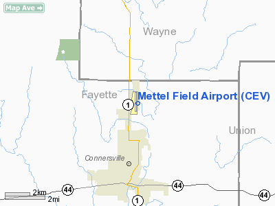
3 nautical miles N of Connersville, IN |
|
Location: |
Fayette County, IN |
|
Magnetic
Variation: |
04W (1995) |
Owner & Manager
|
Ownership: |
Publicly
owned |
|
Owner: |
Connersville Boac |
|
Address: |
500 Western Ave
Connersville,
IN 47331 |
|
Phone
number: |
765-825-5581 |
|
Manager: |
Jeff Dungan |
|
Address: |
500 Western Avenue
Connersville,
IN 47331 |
|
Phone
number: |
765-827-1355 |
Airport
Operations and Facilities
|
Airport
Use: |
Open
to public |
|
Wind indicator: |
No |
|
Segmented
Circle: |
No |
|
Control
Tower: |
No |
|
Lighting
Schedule: |
DUSK-DAWN
MIRL RY 18/36 PRESET LOW INTST; INCR INTST & ACTVT MALSR
RY 18, REIL RYS 18 & 36 - CTAF. |
|
Beacon
Color: |
Clear-Green (lighted land airport)
ROTG BCN OTS INDEFLY. |
|
Landing
fee charge: |
No |
|
Sectional
chart: |
St Louis |
|
Region: |
AGL - Great Lakes |
|
Boundary
ARTCC: |
ZID - Indianapolis |
|
Tie-in
FSS: |
HUF - Terre Haute |
|
FSS on
Airport: |
No |
|
FSS Toll
Free: |
1-800-WX-BRIEF |
|
NOTAMs
Facility: |
HUF (NOTAM-d service avaliable) |
|
Federal
Agreements: |
NGY |
Airport Communications
|
CTAF: |
122.800 |
|
Unicom: |
122.800
|
Airport
Services
|
Fuel
available: |
100LLA |
|
Bottled
Oxygen: |
NONE |
|
Bulk Oxygen: |
NONE |
|
Runway Information
Runway 04/22
|
Dimension: |
2833 x 100 ft
/ 863.5 x 30.5 m |
|
Surface: |
TURF, Good Condition |
|
|
Runway 04 |
Runway 22 |
|
Longitude: |
085-08-06.9700W |
085-07-45.5700W |
|
Latitude: |
39-41-37.7690N |
39-42-00.3690N |
|
Elevation: |
860.00 ft |
860.00 ft |
|
Alignment: |
36 |
127 |
|
Traffic
Pattern: |
Left |
Left |
|
Markings: |
None,
RY 04 & 22 DSPLCD THLDS MARKED BY ORANGE CONES |
None, |
|
Displaced
threshold: |
593.00 ft |
100.00 ft |
|
Runway End
Identifier: |
No |
No |
|
Centerline
Lights: |
No |
No |
|
Touchdown
Lights: |
No |
No |
|
Obstruction: |
41 ft trees, 390.0 ft from runway, 9:1 slope
to clear
APCH RATIO TO DSPLCD THLD 23:1. |
5 ft brush, 20.0 ft from runway, 4:1 slope
to clear
APCH SLOPE AT DSPLCD THLD 24:1. |
|
Runway 18/36
|
Dimension: |
6500 x 100 ft
/ 1981.2 x 30.5 m |
|
Surface: |
ASPH, Good Condition |
|
Surface Treatment: |
Saw-cut or plastic Grooved |
|
Weight Limit: |
Single wheel: 50000 lbs.
Dual wheel: 84000 lbs. |
|
Edge Lights: |
Medium |
|
|
Runway 18 |
Runway 36 |
|
Longitude: |
085-07-50.5160W |
085-07-51.2750W |
|
Latitude: |
39-42-26.7520N |
39-41-22.5160N |
|
Elevation: |
867.00 ft |
861.00 ft |
|
Alignment: |
127 |
127 |
|
ILS Type: |
ILS |
|
|
Traffic
Pattern: |
Left |
Left |
|
Markings: |
Precision instrument, Fair Condition |
Non-precision instrument, Fair Condition |
|
Crossing
Height: |
27.00 ft |
32.00 ft |
|
VASI: |
4-light PAPI on right side |
4-light PAPI on left side |
|
Visual Glide
Angle: |
3.00° |
3.00° |
|
Approach
lights: |
MALSR |
|
|
Runway End
Identifier: |
Yes |
Yes |
|
Centerline
Lights: |
No |
No |
|
Touchdown
Lights: |
No |
No |
|
Obstruction: |
92 ft trees, 3400.0 ft from runway, 34:1 slope
to clear |
113 ft trees, 2280.0 ft from runway, 100 ft
right of centerline, 18:1 slope to clear |
|
Radio Navigation
Aids
|
ID |
Type |
Name |
Ch |
Freq |
Var |
Dist |
|
UWL |
NDB |
New Castle |
|
385.00 |
02W |
14.0 nm |
|
OXD |
NDB |
Oxford |
|
282.00 |
04W |
19.8 nm |
|
HLB |
NDB |
Batesville |
|
254.00 |
02W |
21.8 nm |
|
AI |
NDB |
Video |
|
371.00 |
03W |
28.4 nm |
|
HAO |
NDB |
Hamilton |
|
260.00 |
04W |
32.4 nm |
|
HKF |
NDB |
Hook Field |
|
239.00 |
04W |
33.8 nm |
|
BA |
NDB |
Clifs |
|
410.00 |
03W |
39.1 nm |
|
VES |
NDB |
Versailles |
|
356.00 |
04W |
41.4 nm |
|
UR |
NDB |
Burln |
|
321.00 |
04W |
42.6 nm |
|
ISZ |
NDB |
Cincinnati-blue Ash |
|
388.00 |
04W |
43.7 nm |
|
HFY |
NDB |
Greenwood |
|
398.00 |
02W |
44.6 nm |
|
OVO |
NDB |
North Vernon |
|
374.00 |
02W |
44.7 nm |
|
UMP |
NDB |
Metropolitan |
|
338.00 |
03W |
44.9 nm |
|
PLD |
NDB |
Portland |
|
257.00 |
03W |
45.9 nm |
|
MDE |
NDB |
Madeira |
|
379.00 |
04W |
45.9 nm |
|
LUK |
NDB |
Cincinnati |
|
335.00 |
04W |
48.9 nm |
|
MIE |
VOR/DME |
Muncie |
091X |
114.40 |
03W |
34.6 nm |
|
DQN |
VOR/DME |
Dayton |
092X |
114.50 |
01W |
38.8 nm |
|
RID |
VORTAC |
Richmond |
043X |
110.60 |
03W |
13.9 nm |
|
SHB |
VORTAC |
Shelbyville |
057X |
112.00 |
01E |
32.4 nm |
|
CVG |
VORTAC |
Cincinnati |
120X |
117.30 |
04W |
45.6 nm |
|
DAY |
VOT |
Dayton J M Cox-day |
|
111.00 |
|
43.7 nm |
|
LUK |
VOT |
Cincinnati Muni/lunken |
|
108.40 |
|
48.7 nm |
Remarks
- BIRDS
& DEER ON & INVOF ARPT.
- GCO
AVBL ON FREQ 121.725 THRU DAY CLNC AND FLIGHT SERVICES.
Based Aircraft
|
Aircraft
based on field: |
15 |
|
Single Engine
Airplanes: |
14 |
|
Multi Engine Airplanes: |
1 |
Operational Statistics
Time
Period: 2004-01-02 - 2004-12-31
|
Aircraft
Operations: |
87/Week |
|
Air Taxi: |
3.5% |
|
General Aviation
Local: |
45.0% |
|
General Aviation
Itinerant: |
51.1% |
|
Military: |
0.3% |
Mettel Field Airport
Address:
Fayette County, IN
Tel:
765-825-5581,
765-827-1355
Images
and information placed above are from
http://www.airport-data.com/airport/CEV/
We
thank them for the data!
| General
Info |
| Country |
United
States |
| State |
INDIANA
|
| FAA ID |
CEV |
| Latitude |
39-41-52.913N
|
| Longitude |
085-07-52.483W
|
| Elevation |
867 feet
|
| Near City |
CONNERSVILLE
|
We don't guarantee the information is fresh and accurate. The data may
be wrong or outdated.
For more up-to-date information please refer to other sources.
|
|


