 |
|
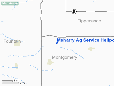
Meharry Ag Service Heliport |
|
|
Location
& QuickFacts
|
FAA
Information Effective: |
2008-06-05 |
|
Airport
Identifier: |
1IN2 |
|
Airport
Status: |
Operational |
|
Longitude/Latitude: |
087-03-21.0280W/40-12-14.1390N
-87.055841/40.203927 (Estimated) |
|
Elevation: |
760 ft / 231.65 m (Estimated) |
|
Land: |
2 acres |
|
From nearest
city: |
2 nautical miles NE of Wingate, IN |
|
Location: |
Montgomery County, IN |
|
Magnetic
Variation: |
01W (1985) |
Owner & Manager
|
Ownership: |
Privately
owned |
|
Owner: |
David L. Meharry |
|
Address: |
Box 212
Wingate,
IN 47994 |
|
Phone
number: |
317-275-2508 |
|
Manager: |
David L. Meharry |
|
Address: |
Box 212
Wingate,
IN 47994 |
|
Phone
number: |
317-275-2508
ALSO RESIDENCE 317-275-2592. |
Airport Operations
and Facilities
|
Airport Use: |
Private |
|
Wind
indicator: |
Yes |
|
Segmented
Circle: |
No |
|
Control
Tower: |
No |
|
Sectional
chart: |
Chicago |
|
Region: |
AGL - Great Lakes |
|
Boundary
ARTCC: |
ZAU - Chicago |
|
Tie-in
FSS: |
HUF - Terre Haute |
|
FSS on
Airport: |
No |
|
FSS Toll
Free: |
1-800-WX-BRIEF |
Airport Services
|
Fuel
available: |
100LL |
|
Airframe
Repair: |
MAJOR |
|
Power
Plant Repair: |
MAJOR |
|
Runway Information
Helipad H1
|
Dimension: |
16 x 16 ft /
4.9 x 4.9 m |
|
Surface: |
CONC, Fair Condition |
|
|
Runway H1 |
Runway |
|
Traffic
Pattern: |
Right |
Left |
|
Markings: |
Nonstandard, Good Condition
PAD MKD WITH SOLID WHITE TRIANGLE ORIENTED TWD MAG NORTH &
BNDY MKGS. |
,
PAD MKD WITH SOLID WHITE TRIANGLE ORIENTED TWD MAG NORTH &
BNDY MKGS. |
|
Obstruction: |
30 ft plines-m, 520.0 ft from runway, 17:1
slope to clear |
|
|
Radio Navigation
Aids
|
ID |
Type |
Name |
Ch |
Freq |
Var |
Dist |
|
CFJ |
NDB |
Crawfordsville |
|
388.00 |
02W |
14.9 nm |
|
FKR |
NDB |
Frankfort |
|
278.00 |
02W |
23.0 nm |
|
TVX |
NDB |
Greencastle |
|
521.00 |
03W |
31.6 nm |
|
MCX |
NDB |
White County |
|
377.00 |
03W |
33.3 nm |
|
HZP |
NDB |
Zionsville |
|
248.00 |
03W |
40.3 nm |
|
PRG |
NDB |
Paris |
|
341.00 |
01E |
41.7 nm |
|
HMJ |
NDB |
Homer |
|
281.00 |
01E |
42.6 nm |
|
GGP |
NDB |
Logansport |
|
263.00 |
01W |
43.5 nm |
|
RZL |
NDB |
Rensselaer |
|
362.00 |
02W |
45.0 nm |
|
UMP |
NDB |
Metropolitan |
|
338.00 |
03W |
48.9 nm |
|
BVT |
VORTAC |
Boiler |
098X |
115.10 |
01E |
21.2 nm |
|
DNV |
VORTAC |
Danville |
047X |
111.00 |
02E |
23.6 nm |
|
VHP |
VORTAC |
Brickyard |
110X |
116.30 |
01E |
39.4 nm |
|
TTH |
VORTAC |
Terre Haute |
100X |
115.30 |
02E |
43.9 nm |
|
GUS |
VORTAC |
Grissom |
21Y |
108.45 |
02W |
49.1 nm |
|
OKK |
VORTAC |
Kokomo |
082X |
113.50 |
00E |
49.7 nm |
|
IND |
VOT |
Indianapolis Intl |
|
109.60 |
|
45.8 nm |
Remarks
- RWY
H1 165' ANT TWR 350' EAST OF PAD.
- REPAIRS
LIMITED TO BELL 47 & FOR BELL 206 MINOR REPAIRS ONLY.
- INGRESS/EGRESS
RTES ESTBD FM 250-280 & 340-020 DEG FM PAD.
Operational Statistics
Time
Period: 1988-05-27 - 1989-05-26
|
Aircraft
Operations: |
15/Week |
|
General Aviation
Local: |
93.3% |
|
General Aviation
Itinerant: |
6.7% |
Meharry Ag Service Heliport
Address:
Montgomery County, IN
Tel:
317-275-2508
Images
and information placed above are from
http://www.airport-data.com/airport/1IN2/
We
thank them for the data!
| General
Info |
| Country |
United
States |
| State |
INDIANA
|
| FAA ID |
1IN2 |
| Latitude |
40-12-14.139N
|
| Longitude |
087-03-21.028W
|
| Elevation |
760 feet
|
| Near City |
WINGATE
|
We don't guarantee the information is fresh and accurate. The data may
be wrong or outdated.
For more up-to-date information please refer to other sources.
|
|


