 |
|
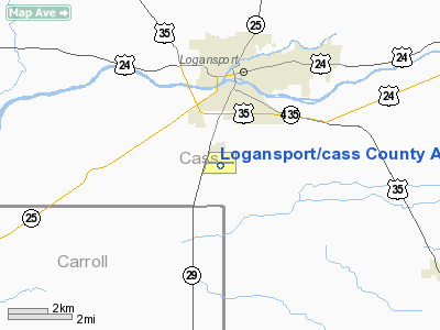
Logansport / Cass County Airport |
|
|
Location
& QuickFacts
|
FAA
Information Effective: |
2008-06-05 |
|
Airport
Identifier: |
GGP |
|
Airport
Status: |
Operational |
|
Longitude/Latitude: |
086-22-29.6000W/40-42-40.5000N
-86.374889/40.711250 (Estimated) |
|
Elevation: |
738 ft / 224.94 m (Surveyed) |
|
Land: |
120 acres |
|
From nearest
city: |
2 nautical miles S of Logansport, IN |
|
Location: |
Cass County, IN |
|
Magnetic
Variation: |
01W (1980) |
Owner
& Manager
|
Ownership: |
Publicly
owned |
|
Owner: |
Logansport Cass Arpt Authority |
|
Address: |
3735 S. Airport Rd
Logansport,
IN 46947 |
|
Phone
number: |
574-735-3082 |
|
Manager: |
Tim Dalton |
|
Address: |
3735 S. Airport Rd
Logansport,
IN 46947 |
|
Phone
number: |
574-735-3082 |
Airport Operations
and Facilities
|
Airport
Use: |
Open
to public |
|
Wind indicator: |
Yes |
|
Segmented
Circle: |
Yes |
|
Control
Tower: |
No |
|
Lighting
Schedule: |
DUSK-DAWN
MIRL RY 09/27 OPERS LOW INTST; TO INCR INTST & ACTVT
REILS RY 09 & 27 - CTAF. |
|
Beacon
Color: |
Clear-Green (lighted land airport) |
|
Landing
fee charge: |
No |
|
Sectional
chart: |
Chicago |
|
Region: |
AGL - Great Lakes |
|
Boundary
ARTCC: |
ZAU - Chicago |
|
Tie-in
FSS: |
HUF - Terre Haute |
|
FSS on
Airport: |
No |
|
FSS Toll
Free: |
1-800-WX-BRIEF |
|
NOTAMs
Facility: |
HUF (NOTAM-d service avaliable) |
|
Federal
Agreements: |
NGY |
Airport Communications
|
CTAF: |
122.800 |
|
Unicom: |
122.800
|
Airport
Services
|
Fuel
available: |
100LLA |
|
Airframe
Repair: |
MAJOR |
|
Power
Plant Repair: |
MAJOR |
|
Bottled
Oxygen: |
NONE |
|
Bulk Oxygen: |
NONE |
|
Runway Information
Runway 09/27
|
Dimension: |
4477 x 75 ft
/ 1364.6 x 22.9 m |
|
Surface: |
ASPH, Fair Condition |
|
Surface Treatment: |
Saw-cut or plastic Grooved |
|
Weight Limit: |
Single wheel: 20000 lbs. |
|
Edge Lights: |
Medium |
|
|
Runway 09 |
Runway 27 |
|
Longitude: |
086-22-58.6632W |
086-22-00.5307W |
|
Latitude: |
40-42-40.2508N |
40-42-40.7256N |
|
Elevation: |
734.00 ft |
738.00 ft |
|
Alignment: |
89 |
127 |
|
Traffic
Pattern: |
Left |
Left |
|
Markings: |
Non-precision instrument, Fair Condition |
Non-precision instrument, Fair Condition |
|
Crossing
Height: |
28.00 ft |
36.00 ft |
|
Displaced
threshold: |
215.00 ft |
0.00 ft |
|
VASI: |
2-light PAPI on left side |
2-light PAPI on right side |
|
Visual Glide
Angle: |
3.00° |
3.00° |
|
Runway End
Identifier: |
No |
No |
|
Centerline
Lights: |
No |
No |
|
Touchdown
Lights: |
No |
No |
|
Obstruction: |
11 ft road, 630.0 ft from runway, 250 ft left
of centerline, 39:1 slope to clear
RWY 09 APCH RATIO 50:1 AT DSPLCD THR. |
12 ft road, 450.0 ft from runway, 20:1 slope
to clear |
|
Decleard
distances: |
Take off run available 4480.00 ft
Take off distance available 4480.00 ft
Actual stop distance available 4480.00 ft
Landing distance available 4262.00 ft |
Take off run available 4262.00 ft
Take off distance available 4262.00 ft
Actual stop distance available 4262.00 ft
Landing distance available 4262.00 ft |
|
Radio Navigation
Aids
|
ID |
Type |
Name |
Ch |
Freq |
Var |
Dist |
|
GGP |
NDB |
Logansport |
|
263.00 |
01W |
0.1 nm |
|
MCX |
NDB |
White County |
|
377.00 |
03W |
17.6 nm |
|
RCR |
NDB |
Rochester |
|
216.00 |
03W |
22.9 nm |
|
RWN |
NDB |
Winamac/dcmsnd |
|
335.00 |
00W |
25.3 nm |
|
IWH |
NDB |
Wabash |
|
329.00 |
03W |
26.5 nm |
|
FKR |
NDB |
Frankfort |
|
278.00 |
02W |
27.8 nm |
|
CPB |
NDB |
Culver |
|
391.00 |
01W |
30.4 nm |
|
RZL |
NDB |
Rensselaer |
|
362.00 |
02W |
39.4 nm |
|
HHG |
NDB |
Huntington |
|
417.00 |
03W |
42.3 nm |
|
HZP |
NDB |
Zionsville |
|
248.00 |
03W |
46.7 nm |
|
UMP |
NDB |
Metropolitan |
|
338.00 |
03W |
48.8 nm |
|
VP |
NDB |
Sedly |
|
212.00 |
02W |
50.0 nm |
|
MZZ |
VOR/DME |
Marion |
023X |
108.60 |
03W |
34.3 nm |
|
OXI |
VOR/DME |
Knox |
103X |
115.60 |
00E |
38.8 nm |
|
GUS |
VORTAC |
Grissom |
21Y |
108.45 |
02W |
10.9 nm |
|
OKK |
VORTAC |
Kokomo |
082X |
113.50 |
00E |
18.2 nm |
|
BVT |
VORTAC |
Boiler |
098X |
115.10 |
01E |
33.0 nm |
Remarks
- SANITARY
LANDFILL 1-1/2 MILES NE OF ARPT.
Based Aircraft
|
Aircraft
based on field: |
12 |
|
Single Engine
Airplanes: |
10 |
|
Multi Engine Airplanes: |
2 |
Operational Statistics
Time
Period: 2005-08-31 - 2006-08-30
|
Aircraft
Operations: |
107/Week |
|
Air Taxi: |
2.8% |
|
General Aviation
Local: |
43.6% |
|
General Aviation
Itinerant: |
49.7% |
|
Military: |
3.8% |
Logansport/cass County Airport
Address:
Cass County, IN
Tel:
574-735-3082
Images
and information placed above are from
http://www.airport-data.com/airport/GGP/
We
thank them for the data!
| General
Info |
| Country |
United
States |
| State |
INDIANA
|
| FAA ID |
GGP |
| Latitude |
40-42-40.541N
|
| Longitude |
086-22-28.197W
|
| Elevation |
738 feet
|
| Near City |
LOGANSPORT
|
We don't guarantee the information is fresh and accurate. The data may
be wrong or outdated.
For more up-to-date information please refer to other sources.
|
|


