 |
|
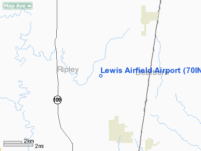
Location
& QuickFacts
|
FAA
Information Effective: |
2008-06-05 |
|
Airport
Identifier: |
70IN |
|
Airport
Status: |
Operational |
|
Longitude/Latitude: |
085-09-04.8520W/39-10-54.1920N
-85.151348/39.181720 (Estimated) |
|
Elevation: |
989 ft / 301.45 m (Estimated) |
|
Land: |
0 acres |
|
From nearest
city: |
4 nautical miles N of Milan, IN |
|
Location: |
Ripley County, IN |
|
Magnetic
Variation: |
03W (1985) |
Owner
& Manager
|
Ownership: |
Privately
owned |
|
Owner: |
Kenneth C. Lewis |
|
Address: |
5937 E Co Rd 700n
Milan, IN 47031 |
|
Phone
number: |
812-654-2452 |
|
Manager: |
Edward L Lewis |
|
Address: |
Rr 2 Box 84a
Milan, IN 47031 |
|
Phone
number: |
812-654-3803 |
Airport Operations
and Facilities
|
Airport
Use: |
Private |
|
Wind indicator: |
Yes |
|
Segmented
Circle: |
No |
|
Control
Tower: |
No |
|
Landing
fee charge: |
No |
|
Sectional
chart: |
St Louis |
|
Region: |
AGL - Great Lakes |
|
Boundary
ARTCC: |
ZID - Indianapolis |
|
Tie-in
FSS: |
HUF - Terre Haute |
|
FSS on
Airport: |
No |
|
FSS Toll
Free: |
1-800-WX-BRIEF |
|
Runway Information
Runway 18/36
|
Dimension: |
2700 x 80 ft
/ 823.0 x 24.4 m |
|
Surface: |
TURF, |
|
|
Runway 18 |
Runway 36 |
|
Traffic
Pattern: |
Right |
Right |
|
Radio Navigation
Aids
|
ID |
Type |
Name |
Ch |
Freq |
Var |
Dist |
|
HLB |
NDB |
Batesville |
|
254.00 |
02W |
11.2 nm |
|
UR |
NDB |
Burln |
|
321.00 |
04W |
19.4 nm |
|
OVO |
NDB |
North Vernon |
|
374.00 |
02W |
22.4 nm |
|
OXD |
NDB |
Oxford |
|
282.00 |
04W |
26.1 nm |
|
IMS |
NDB |
Madison |
|
404.00 |
03W |
29.1 nm |
|
HAO |
NDB |
Hamilton |
|
260.00 |
04W |
29.3 nm |
|
BA |
NDB |
Clifs |
|
410.00 |
03W |
32.2 nm |
|
ISZ |
NDB |
Cincinnati-blue Ash |
|
388.00 |
04W |
35.7 nm |
|
MDE |
NDB |
Madeira |
|
379.00 |
04W |
37.2 nm |
|
LUK |
NDB |
Cincinnati |
|
335.00 |
04W |
37.8 nm |
|
HKF |
NDB |
Hook Field |
|
239.00 |
04W |
37.9 nm |
|
UWL |
NDB |
New Castle |
|
385.00 |
02W |
42.7 nm |
|
EQZ |
NDB |
Captain |
|
308.00 |
02W |
42.8 nm |
|
PWF |
NDB |
Sportys |
|
245.00 |
04W |
44.1 nm |
|
CVG |
VORTAC |
Cincinnati |
120X |
117.30 |
04W |
23.2 nm |
|
RID |
VORTAC |
Richmond |
043X |
110.60 |
03W |
37.4 nm |
|
SHB |
VORTAC |
Shelbyville |
057X |
112.00 |
01E |
41.4 nm |
|
ABB |
VORTAC |
Nabb |
071X |
112.40 |
01E |
42.2 nm |
|
LUK |
VOT |
Cincinnati Muni/lunken |
|
108.40 |
|
35.2 nm |
Based Aircraft
|
Aircraft
based on field: |
1 |
|
Single Engine
Airplanes: |
1 |
Lewis Airfield Airport
Address:
Ripley County, IN
Tel:
812-654-2452,
812-654-3803
Images
and information placed above are from
http://www.airport-data.com/airport/70IN/
We
thank them for the data!
| General
Info |
| Country |
United
States |
| State |
INDIANA
|
| FAA ID |
70IN |
| Latitude |
39-10-54.192N
|
| Longitude |
085-09-04.852W
|
| Elevation |
989 feet
|
| Near City |
MILAN
|
We don't guarantee the information is fresh and accurate. The data may
be wrong or outdated.
For more up-to-date information please refer to other sources.
|
|


