 |
|
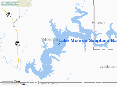
Lake Monroe Seaplane Base |
Location
& QuickFacts
|
FAA
Information Effective: |
2008-06-05 |
|
Airport
Identifier: |
07I |
|
Airport
Status: |
Operational |
|
Longitude/Latitude: |
086-26-45.9760W/39-03-31.1750N
-86.446104/39.058660 (Estimated) |
|
Elevation: |
538 ft / 163.98 m (Estimated) |
|
Land: |
10750 acres |
|
From nearest
city: |
7 nautical miles SE of Bloomington, IN |
|
Location: |
Monroe County, IN |
|
Magnetic
Variation: |
02W (1985) |
Owner & Manager
|
Ownership: |
Publicly
owned |
|
Owner: |
Dept Of Natural Resources |
|
Address: |
4850 State Road 446
Bloomington, IN 47401 |
|
Phone
number: |
812-837-9546 |
|
Manager: |
Jim Roach |
|
Address: |
4850 State Road 446
Bloomington, IN 47401 |
|
Phone
number: |
812-837-9546 |
Airport
Operations and Facilities
|
Airport
Use: |
Open
to public |
|
Segmented
Circle: |
No |
|
Control
Tower: |
No |
|
Sectional
chart: |
St Louis |
|
Region: |
AGL - Great Lakes |
|
Boundary
ARTCC: |
ZID - Indianapolis |
|
Tie-in
FSS: |
HUF - Terre Haute |
|
FSS on
Airport: |
No |
|
FSS Toll
Free: |
1-800-WX-BRIEF |
|
NOTAMs
Facility: |
HUF (NOTAM-d service avaliable) |
Airport
Communications
|
Runway Information
Runway SW/NE
|
Dimension: |
15000 x 4000
ft / 4572.0 x 1219.2 m |
|
Surface: |
WATER, |
|
|
Runway NE |
Runway SW |
|
Traffic
Pattern: |
Left |
Left |
|
Markings: |
None, |
None, |
|
Radio Navigation
Aids
|
ID |
Type |
Name |
Ch |
Freq |
Var |
Dist |
|
BM |
NDB |
Claye |
|
382.00 |
02W |
7.1 nm |
|
BFR |
NDB |
Bedford |
|
344.00 |
02W |
13.2 nm |
|
EQZ |
NDB |
Captain |
|
308.00 |
02W |
24.9 nm |
|
RRJ |
NDB |
Oranj |
|
368.00 |
02W |
32.1 nm |
|
BA |
NDB |
Clifs |
|
410.00 |
03W |
33.2 nm |
|
HFY |
NDB |
Greenwood |
|
398.00 |
02W |
38.3 nm |
|
DCY |
NDB |
Washington |
|
212.00 |
03W |
38.8 nm |
|
OVO |
NDB |
North Vernon |
|
374.00 |
02W |
39.4 nm |
|
TVX |
NDB |
Greencastle |
|
521.00 |
03W |
42.8 nm |
|
SIV |
NDB |
Sullivan |
|
326.00 |
02W |
46.8 nm |
|
HU |
NDB |
Yinno |
|
245.00 |
02W |
48.5 nm |
|
IMS |
NDB |
Madison |
|
404.00 |
03W |
49.5 nm |
|
OOM |
VORTAC |
Hoosier |
039X |
110.20 |
02W |
9.3 nm |
|
SHB |
VORTAC |
Shelbyville |
057X |
112.00 |
01E |
45.0 nm |
|
TTH |
VORTAC |
Terre Haute |
100X |
115.30 |
02E |
45.4 nm |
|
VHP |
VORTAC |
Brickyard |
110X |
116.30 |
01E |
45.6 nm |
|
ABB |
VORTAC |
Nabb |
071X |
112.40 |
01E |
47.3 nm |
|
IND |
VOT |
Indianapolis Intl |
|
109.60 |
|
40.7 nm |
Remarks
- SEAPLANE
OPNS PROHIBITED BTN SS-SR.
- LOW
ALT HI-SPEED MIL TRNG ACTVTY OVR OR NEAR RESERVOIR - CTC HUF AFSS FOR
INFO.
Operational Statistics
Time
Period: 2004-01-02 - 2004-12-31
|
Aircraft
Operations: |
1/Month |
|
General Aviation
Itinerant: |
100.0% |
Lake Monroe Seaplane Base
Address:
Monroe County, IN
Tel:
812-837-9546
Images
and information placed above are from
http://www.airport-data.com/airport/07I/
We
thank them for the data!
| General
Info |
| Country |
United
States |
| State |
INDIANA
|
| FAA ID |
07I |
| Latitude |
39-03-31.175N
|
| Longitude |
086-26-45.976W
|
| Elevation |
538 feet
|
| Near City |
BLOOMINGTON
|
We don't guarantee the information is fresh and accurate. The data may
be wrong or outdated.
For more up-to-date information please refer to other sources.
|
|


