|
|
La Porte Municipal Airport |
Coordinates: 41°34â²21â³N 086°44â²04â³W / 41.5725°N 86.73444°W / 41.5725; -86.73444
| La Porte Municipal Airport |
| IATA: LPO â ICAO: KPPO â FAA LID: PPO |
| Summary |
| Airport type |
Public |
| Owner |
La Porte Airport Authority |
| Serves |
La Porte, Indiana |
| Elevation AMSL |
812 ft / 247 m |
| Runways |
| Direction |
Length |
Surface |
| ft |
m |
| 2/20 |
5,000 |
1,524 |
Asphalt |
| 14/32 |
2,800 |
853 |
Asphalt |
| Statistics (2005) |
| Aircraft operations |
15,416 |
| Based aircraft |
78 |
| Source: Federal Aviation Administration |
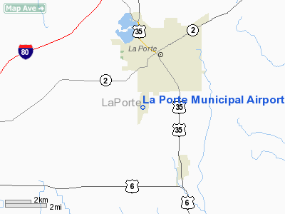
La Porte Municipal Airport (IATA: LPO, ICAO: KPPO, FAA LID: PPO) is a city-owned public-use airport located three miles (5 km) south of the central business district of La Porte, a city in La Porte County, Indiana, United States.
Although most U.S. airports use the same three-letter location identifier for the FAA and IATA, La Porte Municipal Airport is assigned PPO by the FAA and LPO by the IATA. The airport's ICAO identifier is KPPO.
Facilities and aircraft
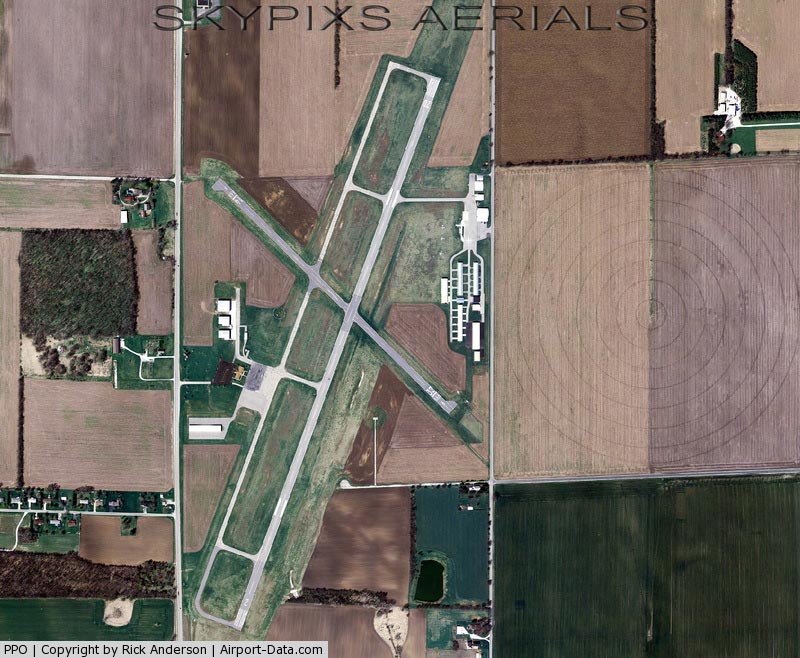
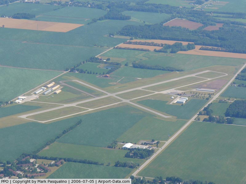
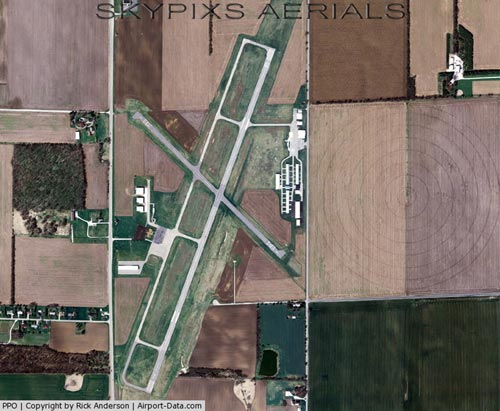
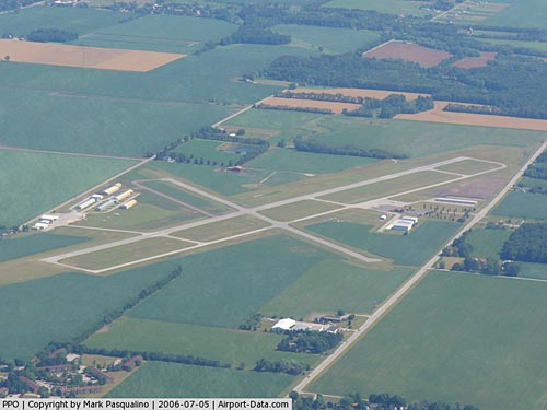
La Porte Municipal Airport covers an area of 188 acres (76 ha) which contains two asphalt paved runways: 2/20 at 5,000 x 75 ft (1,524 x 23 m) and 14/32 meassuring 2,800 x 60 ft (853 x 18 m).
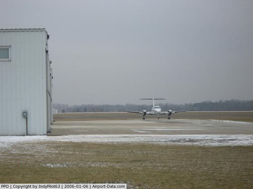
For the 12-month period ending December 31, 2005, the airport had 15,416 aircraft operations, an average of 42 per day: 99.7% general aviation and 0.3% air taxi. There are 78 aircraft based at this airport: 91% single-engine, 5% multi-engine and 4% jet.
The above content comes from Wikipedia and is published under free licenses – click here to read more.
|
 |
(Click on the photo to enlarge) |
|
 |
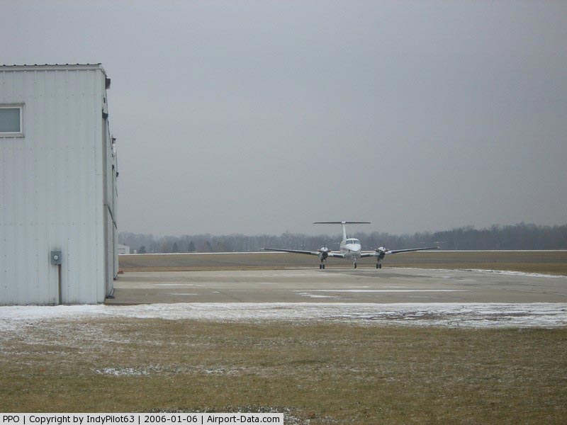
(Click on the photo to enlarge) |
|
 |
(Click on the photo to enlarge) |
|
 |
(Click on the photo to enlarge) |
Location
& QuickFacts
|
FAA
Information Effective: |
2008-06-05 |
|
Airport
Identifier: |
PPO |
|
Airport
Status: |
Operational |
|
Longitude/Latitude: |
086-44-04.2990W/41-34-20.9000N
-86.734527/41.572472 (Estimated) |
|
Elevation: |
812 ft / 247.50 m (Surveyed) |
|
Land: |
188 acres |
|
From nearest
city: |
3 nautical miles S of La Porte, IN |
|
Location: |
La Porte County, IN |
|
Magnetic
Variation: |
03W (1995) |
Owner
& Manager
|
Ownership: |
Publicly
owned |
|
Owner: |
La Porte Airport Authority
EDWARD L VOLK, PRESIDENT. |
|
Address: |
2341 State Rd 39s
La Porte, IN 46350 |
|
Phone
number: |
219-324-3393 |
|
Manager: |
Nikki Anderson |
|
Address: |
2341 State Rd 39s
La Porte, IN 46350 |
|
Phone
number: |
219-324-3393 |
Airport Operations
and Facilities
|
Airport
Use: |
Open
to public |
|
Wind indicator: |
Yes |
|
Segmented
Circle: |
Yes |
|
Control
Tower: |
No |
|
Lighting
Schedule: |
DUSK-DAWN
ACTVT MIRL RY 02/20; REIL & PAPI RYS 02 & 20 - CTAF. |
|
Beacon
Color: |
Clear-Green (lighted land airport) |
|
Landing
fee charge: |
No |
|
Sectional
chart: |
Chicago |
|
Region: |
AGL - Great Lakes |
|
Boundary
ARTCC: |
ZAU - Chicago |
|
Tie-in
FSS: |
HUF - Terre Haute |
|
FSS on
Airport: |
No |
|
FSS Toll
Free: |
1-800-WX-BRIEF |
|
NOTAMs
Facility: |
HUF (NOTAM-d service avaliable) |
|
Federal
Agreements: |
NGY |
Airport Communications
|
CTAF: |
123.000 |
|
Unicom: |
123.000
|
Airport
Services
|
Fuel
available: |
100LLA
MOGAS |
|
Airframe
Repair: |
MINOR |
|
Power
Plant Repair: |
MINOR |
|
Bottled
Oxygen: |
NONE |
|
Bulk Oxygen: |
NONE |
|
Runway Information
Runway 02/20
|
Dimension: |
5000 x 75 ft
/ 1524.0 x 22.9 m |
|
Surface: |
ASPH, Good Condition |
|
Surface Treatment: |
Saw-cut or plastic Grooved |
|
Weight Limit: |
Single wheel: 18000 lbs. |
|
Edge Lights: |
Medium |
|
|
Runway 02 |
Runway 20 |
|
Longitude: |
086-44-15.5300W |
086-43-52.9202W |
|
Latitude: |
41-33-55.9700N |
41-34-42.3459N |
|
Elevation: |
801.00 ft |
812.00 ft |
|
Alignment: |
20 |
127 |
|
ILS Type: |
LOCALIZER |
|
|
Traffic
Pattern: |
Left |
Left |
|
Markings: |
Non-precision instrument, Fair Condition |
Non-precision instrument, Fair Condition |
|
Crossing
Height: |
22.00 ft |
27.00 ft |
|
VASI: |
2-light PAPI on left side |
2-light PAPI on left side |
|
Visual Glide
Angle: |
3.00° |
3.45° |
|
Runway End
Identifier: |
Yes |
Yes |
|
Centerline
Lights: |
No |
No |
|
Touchdown
Lights: |
No |
No |
|
Obstruction: |
54 ft trees, 1500.0 ft from runway, 130 ft
left of centerline, 24:1 slope to clear |
80 ft trees, 1900.0 ft from runway, 21:1 slope
to clear |
|
Runway 14/32
|
Dimension: |
2800 x 60 ft
/ 853.4 x 18.3 m |
|
Surface: |
ASPH, Good Condition |
|
|
Runway 14 |
Runway 32 |
|
Longitude: |
086-44-17.6400W |
086-43-51.2200W |
|
Latitude: |
41-34-33.6500N |
41-34-14.3700N |
|
Elevation: |
810.00 ft |
800.00 ft |
|
Alignment: |
127 |
127 |
|
Traffic
Pattern: |
Left |
Left |
|
Markings: |
Basic, Good Condition |
Basic, Good Condition |
|
Displaced
threshold: |
200.00 ft |
200.00 ft |
|
Runway End
Identifier: |
No |
No |
|
Centerline
Lights: |
No |
No |
|
Touchdown
Lights: |
No |
No |
|
Obstruction: |
18 ft road, 452.0 ft from runway, 14:1 slope
to clear
CLOSEST INTERCEPT POINT.
APPCH
SLOPE TO DISP THLD 36:1. |
15 ft road, 295.0 ft from runway, 125 ft right
of centerline, 19:1 slope to clear
CLOSEST INTERCEPT POINT. |
|
Radio Navigation
Aids
|
ID |
Type |
Name |
Ch |
Freq |
Var |
Dist |
|
IUL |
NDB |
La Porte |
|
356.00 |
03W |
4.7 nm |
|
MGC |
NDB |
Michigan City |
|
203.00 |
01W |
8.9 nm |
|
VP |
NDB |
Sedly |
|
212.00 |
02W |
9.7 nm |
|
CPB |
NDB |
Culver |
|
391.00 |
01W |
26.6 nm |
|
RWN |
NDB |
Winamac/dcmsnd |
|
335.00 |
00W |
29.4 nm |
|
RCR |
NDB |
Rochester |
|
216.00 |
03W |
39.2 nm |
|
RZL |
NDB |
Rensselaer |
|
362.00 |
02W |
42.7 nm |
|
MX |
NDB |
Kedzi |
|
248.00 |
01W |
44.1 nm |
|
OXI |
VOR/DME |
Knox |
103X |
115.60 |
00E |
15.5 nm |
|
ELX |
VOR/DME |
Keeler |
113X |
116.60 |
00E |
44.0 nm |
|
GIJ |
VORTAC |
Gipper |
101X |
115.40 |
00E |
22.1 nm |
|
GSH |
VORTAC |
Goshen |
084X |
113.70 |
00E |
31.9 nm |
|
CGT |
VORTAC |
Chicago Heights |
089X |
114.20 |
02E |
37.8 nm |
|
MDW |
VOT |
Chicago Midway |
|
111.00 |
|
47.5 nm |
Remarks
- CTN:
FARM EQUIP ON/OR NEAR ACFT OPNS AREAS.
- PCL
OTS INDEFLY, EXCEPT LOW INTST.
- EXISTED
PRIOR TO 1959.
Based Aircraft
|
Aircraft
based on field: |
78 |
|
Single Engine
Airplanes: |
71 |
|
Multi Engine Airplanes: |
4 |
|
Jet Engine Airplanes: |
3 |
Operational Statistics
Time
Period: 2005-01-01 - 2005-12-31
|
Aircraft
Operations: |
297/Week |
|
Air Taxi: |
0.3% |
|
General Aviation
Local: |
46.8% |
|
General Aviation
Itinerant: |
52.9% |
La Porte Municipal Airport
Address:
La Porte County, IN
Tel:
219-324-3393
Images
and information placed above are from
http://www.airport-data.com/airport/PPO/
We
thank them for the data!
| General
Info |
| Country |
United
States |
| State |
INDIANA
|
| FAA ID |
PPO |
| Latitude |
41-34-22.300N
|
| Longitude |
086-44-02.900W
|
| Elevation |
812 feet
|
| Near City |
LA PORTE
|
We don't guarantee the information is fresh and accurate. The data may
be wrong or outdated.
For more up-to-date information please refer to other sources.
|
|