 |
|
|
|
|
|
Location
& QuickFacts
|
FAA
Information Effective: |
2008-06-05 |
|
Airport
Identifier: |
OKK |
|
Airport
Status: |
Operational |
|
Longitude/Latitude: |
086-03-32.3640W/40-31-41.4390N
-86.058990/40.528178 (Estimated) |
|
Elevation: |
830 ft / 252.98 m (Surveyed) |
|
Land: |
432 acres |
|
From nearest
city: |
4 nautical miles NE of Kokomo, IN |
|
Location: |
Howard County, IN |
|
Magnetic
Variation: |
02W (1985) |
Owner
& Manager
|
Ownership: |
Publicly
owned |
|
Owner: |
Kokomo Boac |
|
Address: |
3637 E County Rd 400n
Kokomo, IN 46901 |
|
Phone
number: |
765-456-7541 |
|
Manager: |
Frank Cade |
|
Address: |
3637 E County Rd 400n
Kokomo, IN 46901 |
|
Phone
number: |
765-456-7541 |
Airport Operations
and Facilities
|
Airport
Use: |
Open
to public |
|
Wind indicator: |
Yes |
|
Segmented
Circle: |
No |
|
Control
Tower: |
No |
|
Lighting
Schedule: |
DUSK-DAWN
ACTVT HIRL RY 05/23 & MIRL RY 14/32; PAPI & REIL
RYS 05; 14; 32 & MALSR RY 23 - CTAF. |
|
Beacon
Color: |
Clear-Green (lighted land airport) |
|
Landing
fee charge: |
No |
|
Sectional
chart: |
Chicago |
|
Region: |
AGL - Great Lakes |
|
Boundary
ARTCC: |
ZAU - Chicago |
|
Tie-in
FSS: |
HUF - Terre Haute |
|
FSS on
Airport: |
No |
|
FSS Toll
Free: |
1-800-WX-BRIEF |
|
NOTAMs
Facility: |
OKK (NOTAM-d service avaliable) |
|
Federal
Agreements: |
NGY3 |
Airport Communications
|
CTAF: |
123.000 |
|
Unicom: |
123.000
|
Airport
Services
|
Fuel
available: |
100LLA1+ |
|
Airframe
Repair: |
MAJOR |
|
Power
Plant Repair: |
MAJOR |
|
Bottled
Oxygen: |
HIGH |
|
Runway Information
Runway 05/23
|
Dimension: |
5201 x 150 ft
/ 1585.3 x 45.7 m |
|
Surface: |
ASPH, Good Condition |
|
Surface Treatment: |
Saw-cut or plastic Grooved |
|
Weight Limit: |
Single wheel: 56000 lbs.
Dual wheel: 75000 lbs.
Dual tandem wheel: 95000 lbs. |
|
Edge Lights: |
High |
|
|
Runway 05 |
Runway 23 |
|
Longitude: |
086-04-02.2390W |
086-03-14.6710W |
|
Latitude: |
40-31-21.4200N |
40-31-57.7990N |
|
Elevation: |
830.00 ft |
819.00 ft |
|
Alignment: |
45 |
127 |
|
ILS Type: |
|
ILS |
|
Traffic
Pattern: |
Left |
Left |
|
Markings: |
Non-precision instrument, Fair Condition |
Precision instrument, Fair Condition |
|
VASI: |
2-light PAPI on left side |
|
|
Approach
lights: |
|
MALSR |
|
Runway End
Identifier: |
Yes |
No |
|
Centerline
Lights: |
No |
No |
|
Touchdown
Lights: |
No |
No |
|
Obstruction: |
30 ft trees, 1200.0 ft from runway, 33:1 slope
to clear |
35 ft *, 1860.0 ft from runway, 350 ft left
of centerline, 47:1 slope to clear |
|
Runway 14/32
|
Dimension: |
4001 x 150 ft
/ 1219.5 x 45.7 m |
|
Surface: |
ASPH, Good Condition |
|
Surface Treatment: |
Saw-cut or plastic Grooved |
|
Weight Limit: |
Single wheel: 50000 lbs.
Dual wheel: 60000 lbs.
Dual tandem wheel: 95000 lbs. |
|
Edge Lights: |
Medium |
|
|
Runway 14 |
Runway 32 |
|
Longitude: |
086-03-42.7850W |
086-03-06.2370W |
|
Latitude: |
40-31-57.7140N |
40-31-29.6950N |
|
Elevation: |
826.00 ft |
824.00 ft |
|
Alignment: |
127 |
127 |
|
Traffic
Pattern: |
Left |
Left |
|
Markings: |
Non-precision instrument, Good Condition |
Non-precision instrument, Good Condition |
|
VASI: |
2-light PAPI on left side |
2-light PAPI on left side |
|
Runway End
Identifier: |
Yes |
Yes
REIL OTS INDEFLY. |
|
Centerline
Lights: |
No |
No |
|
Touchdown
Lights: |
No |
No |
|
Obstruction: |
, 50:1 slope to clear |
37 ft tree, 2175.0 ft from runway, 200 ft right
of centerline, 50:1 slope to clear |
|
Radio Navigation
Aids
|
ID |
Type |
Name |
Ch |
Freq |
Var |
Dist |
|
GGP |
NDB |
Logansport |
|
263.00 |
01W |
18.0 nm |
|
IWH |
NDB |
Wabash |
|
329.00 |
03W |
18.5 nm |
|
FKR |
NDB |
Frankfort |
|
278.00 |
02W |
27.8 nm |
|
RCR |
NDB |
Rochester |
|
216.00 |
03W |
32.8 nm |
|
HHG |
NDB |
Huntington |
|
417.00 |
03W |
33.5 nm |
|
MCX |
NDB |
White County |
|
377.00 |
03W |
33.9 nm |
|
UMP |
NDB |
Metropolitan |
|
338.00 |
03W |
35.5 nm |
|
HZP |
NDB |
Zionsville |
|
248.00 |
03W |
36.4 nm |
|
AI |
NDB |
Video |
|
371.00 |
03W |
37.3 nm |
|
RWN |
NDB |
Winamac/dcmsnd |
|
335.00 |
00W |
42.1 nm |
|
CPB |
NDB |
Culver |
|
391.00 |
01W |
44.0 nm |
|
PLD |
NDB |
Portland |
|
257.00 |
03W |
49.4 nm |
|
MZZ |
VOR/DME |
Marion |
023X |
108.60 |
03W |
17.5 nm |
|
MIE |
VOR/DME |
Muncie |
091X |
114.40 |
03W |
35.1 nm |
|
GUS |
VORTAC |
Grissom |
21Y |
108.45 |
02W |
8.2 nm |
|
VHP |
VORTAC |
Brickyard |
110X |
116.30 |
01E |
45.2 nm |
|
BVT |
VORTAC |
Boiler |
098X |
115.10 |
01E |
46.2 nm |
|
FWA |
VORTAC |
Fort Wayne |
125X |
117.80 |
00E |
48.0 nm |
|
FWA |
VOT |
Fort Wayne Baer |
|
111.00 |
|
47.9 nm |
|
IND |
VOT |
Indianapolis Intl |
|
|
|
|
Based Aircraft
|
Aircraft
based on field: |
59 |
|
Single Engine
Airplanes: |
52 |
|
Multi Engine Airplanes: |
5 |
|
Jet Engine Airplanes: |
1 |
|
Helicopters: |
1 |
Operational Statistics
Time
Period: 2005-09-16 - 2006-09-15
|
Aircraft
Operations: |
81/Day |
|
Air Taxi: |
2.9% |
|
General Aviation
Local: |
43.6% |
|
General Aviation
Itinerant: |
49.7% |
|
Military: |
3.8% |
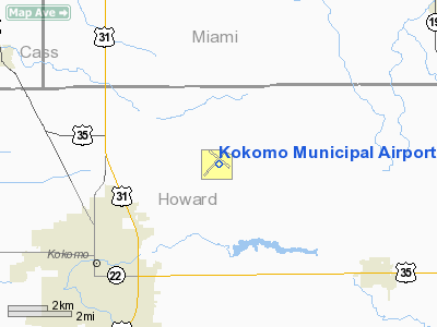
Kokomo Municipal Airport
Address:
Howard County, IN
Tel:
765-456-7541
Images
and information placed above are from
http://www.airport-data.com/airport/OKK/
We
thank them for the data!
| General
Info |
| Country |
United
States |
| State |
INDIANA
|
| FAA ID |
OKK |
| Latitude |
40-31-41.439N
|
| Longitude |
086-03-32.364W
|
| Elevation |
830 feet
|
| Near City |
KOKOMO
|
We don't guarantee the information is fresh and accurate. The data may
be wrong or outdated.
For more up-to-date information please refer to other sources.
|
|


