 |
|
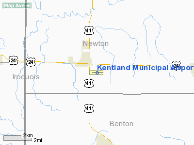
Kentland Municipal Airport |
|
|
Location
& QuickFacts
|
FAA
Information Effective: |
2008-06-05 |
|
Airport
Identifier: |
50I |
|
Airport
Status: |
Operational |
|
Longitude/Latitude: |
087-25-41.5890W/40-45-31.4360N
-87.428219/40.758732 (Estimated) |
|
Elevation: |
698 ft / 212.75 m (Surveyed) |
|
Land: |
50 acres |
|
From nearest
city: |
1 nautical miles SE of Kentland, IN |
|
Location: |
Newton County, IN |
|
Magnetic
Variation: |
01E (1965) |
Owner
& Manager
|
Ownership: |
Publicly
owned |
|
Owner: |
Kentland Board Of Aviation Comm |
|
Address: |
Po Box 218
Kentland, IN 47951 |
|
Phone
number: |
219-474-9080 |
|
Manager: |
Harold Lehman |
|
Address: |
2291 W. 1635 S.
Kentland, IN 47951 |
|
Phone
number: |
219-474-9080 |
Airport
Operations and Facilities
|
Airport
Use: |
Open
to public |
|
Wind indicator: |
Yes |
|
Segmented
Circle: |
No |
|
Control
Tower: |
No |
|
Lighting
Schedule: |
DUSK-DAWN
HIRL RY 09/27 OPER LOW INTST; TO INCR INTST & ACTVT
REIL RYS 09 & 27 & PAPI RYS 09 & 27 - CTAF. |
|
Beacon
Color: |
Clear-Green (lighted land airport) |
|
Landing
fee charge: |
No |
|
Sectional
chart: |
Chicago |
|
Region: |
AGL - Great Lakes |
|
Boundary
ARTCC: |
ZAU - Chicago |
|
Tie-in
FSS: |
HUF - Terre Haute |
|
FSS on
Airport: |
No |
|
FSS Toll
Free: |
1-800-WX-BRIEF |
|
NOTAMs
Facility: |
HUF (NOTAM-d service avaliable) |
|
Federal
Agreements: |
N |
Airport
Communications
|
CTAF: |
122.800 |
|
Unicom: |
122.800
|
Airport
Services
|
Fuel
available: |
100LL80
A |
|
Airframe
Repair: |
MAJOR |
|
Power
Plant Repair: |
MAJOR |
|
Runway Information
Runway 09/27
|
Dimension: |
3504 x 50 ft
/ 1068.0 x 15.2 m |
|
Surface: |
ASPH, Good Condition |
|
Edge Lights: |
High |
|
|
Runway 09 |
Runway 27 |
|
Longitude: |
087-26-04.3790W |
087-25-18.8480W |
|
Latitude: |
40-45-31.5540N |
40-45-31.3810N |
|
Elevation: |
698.00 ft |
698.00 ft |
|
Alignment: |
90 |
127 |
|
Traffic
Pattern: |
Left |
Left |
|
Markings: |
Basic, Fair Condition |
Basic, Fair Condition |
|
Crossing
Height: |
36.00 ft |
25.00 ft |
|
VASI: |
2-light PAPI on left side |
2-light PAPI on left side |
|
Visual Glide
Angle: |
3.00° |
3.00° |
|
Runway End
Identifier: |
Yes |
Yes |
|
Obstruction: |
10 ft crops, 201.0 ft from runway |
15 ft road, 490.0 ft from runway, 19 ft right
of centerline |
|
Radio Navigation
Aids
|
ID |
Type |
Name |
Ch |
Freq |
Var |
Dist |
|
RZL |
NDB |
Rensselaer |
|
362.00 |
02W |
15.9 nm |
|
MCX |
NDB |
White County |
|
377.00 |
03W |
30.5 nm |
|
RWN |
NDB |
Winamac/dcmsnd |
|
335.00 |
00W |
42.5 nm |
|
GGP |
NDB |
Logansport |
|
263.00 |
01W |
48.1 nm |
|
VP |
NDB |
Sedly |
|
212.00 |
02W |
48.5 nm |
|
FKR |
NDB |
Frankfort |
|
278.00 |
02W |
49.2 nm |
|
IKK |
VOR/DME |
Kankakee |
053X |
111.60 |
00E |
27.0 nm |
|
RBS |
VOR/DME |
Roberts |
115X |
116.80 |
02E |
35.2 nm |
|
OXI |
VOR/DME |
Knox |
103X |
115.60 |
00E |
48.9 nm |
|
BVT |
VORTAC |
Boiler |
098X |
115.10 |
01E |
20.4 nm |
|
DNV |
VORTAC |
Danville |
047X |
111.00 |
02E |
28.6 nm |
|
EON |
VORTAC |
Peotone |
079X |
113.20 |
02E |
34.8 nm |
|
CGT |
VORTAC |
Chicago Heights |
089X |
114.20 |
02E |
45.6 nm |
Remarks
- RY
09 - +70 FT UNLGTD GRAIN LEG 185 FT N OF CNTRLN 1060 FT FM RY END.
- RY
09/27 - UNLGTD +37 FT PLINE 1267 FT FM WEST END MARKED WITH RED BALLS.
- RY
09/27 - CROPS 115 FT N & S OF CL FOR WHOLE LENGTH.
- 100LL
& A FUEL AVBL SELF SERVICE.
Based Aircraft
|
Aircraft
based on field: |
22 |
|
Single Engine
Airplanes: |
17 |
|
Helicopters: |
1 |
|
Ultralights: |
4 |
Operational Statistics
Time
Period: 2005-05-27 - 2006-05-26
|
Aircraft
Operations: |
140/Week |
|
Air Taxi: |
9.0% |
|
General Aviation
Local: |
85.0% |
|
General Aviation
Itinerant: |
6.0% |
Kentland Municipal Airport
Address:
Newton County, IN
Tel:
219-474-9080
Images
and information placed above are from
http://www.airport-data.com/airport/50I/
We
thank them for the data!
| General
Info |
| Country |
United
States |
| State |
INDIANA
|
| FAA ID |
50I |
| Latitude |
40-45-31.436N
|
| Longitude |
087-25-41.589W
|
| Elevation |
698 feet
|
| Near City |
KENTLAND
|
We don't guarantee the information is fresh and accurate. The data may
be wrong or outdated.
For more up-to-date information please refer to other sources.
|
|


