 |
|
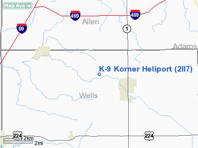
Location
& QuickFacts
|
FAA
Information Effective: |
2008-06-05 |
|
Airport
Identifier: |
2II7 |
|
Airport
Status: |
Operational |
|
Longitude/Latitude: |
085-12-17.8950W/40-53-33.1700N
-85.204971/40.892547 (Estimated) |
|
Elevation: |
825 ft / 251.46 m (Estimated) |
|
Land: |
0 acres |
|
From nearest
city: |
2 nautical miles W of Ossian, IN |
|
Location: |
Wells County, IN |
|
Magnetic
Variation: |
03W (1990) |
Owner
& Manager
|
Ownership: |
Privately
owned |
|
Owner: |
Keyth Price |
|
Address: |
10294 N. 100 East
Ossian, IN 46777 |
|
Phone
number: |
219-622-7751 |
|
Address: |
|
Airport
Operations and Facilities
|
Airport
Use: |
Private
PERSONAL USE. |
|
Wind indicator: |
Yes |
|
Segmented
Circle: |
No |
|
Control
Tower: |
No |
|
Lighting
Schedule: |
24 HRS
FOR FLOOD LGTS PHONE 219-622-7751. |
|
Beacon
Color: |
Clear-Green-Yellow (heliport) |
|
Sectional
chart: |
Chicago |
|
Region: |
AGL - Great Lakes |
|
Boundary
ARTCC: |
ZAU - Chicago |
|
Tie-in
FSS: |
HUF - Terre Haute |
|
FSS
on Airport: |
No |
|
FSS
Toll Free: |
1-800-WX-BRIEF |
Airport
Services
|
Runway Information
Helipad H1
|
Dimension: |
16 x 16 ft /
4.9 x 4.9 m |
|
Surface: |
CONC, |
|
|
Runway H1 |
Runway |
|
Traffic
Pattern: |
Left |
Left |
|
Radio Navigation
Aids
|
ID |
Type |
Name |
Ch |
Freq |
Var |
Dist |
|
HHG |
NDB |
Huntington |
|
417.00 |
03W |
12.0 nm |
|
VFU |
NDB |
Stanley |
|
411.00 |
05W |
26.9 nm |
|
IWH |
NDB |
Wabash |
|
329.00 |
03W |
28.1 nm |
|
PLD |
NDB |
Portland |
|
257.00 |
03W |
28.2 nm |
|
CQA |
NDB |
Lakefield |
|
205.00 |
04W |
38.2 nm |
|
DFI |
NDB |
Defiance |
|
246.00 |
05W |
44.1 nm |
|
ANQ |
NDB |
Angola |
|
347.00 |
05W |
45.2 nm |
|
RCR |
NDB |
Rochester |
|
216.00 |
03W |
45.9 nm |
|
BYN |
NDB |
Bryan |
|
260.00 |
04W |
48.6 nm |
|
OLK |
VOR |
Wolf Lake |
|
110.40 |
03W |
25.1 nm |
|
MZZ |
VOR/DME |
Marion |
023X |
108.60 |
03W |
32.3 nm |
|
MIE |
VOR/DME |
Muncie |
091X |
114.40 |
03W |
40.3 nm |
|
FWA |
VORTAC |
Fort Wayne |
125X |
117.80 |
00E |
5.3 nm |
|
OKK |
VORTAC |
Kokomo |
082X |
113.50 |
00E |
44.6 nm |
|
GUS |
VORTAC |
Grissom |
21Y |
108.45 |
02W |
45.6 nm |
|
FWA |
VOT |
Fort Wayne Baer |
|
111.00 |
|
5.2 nm |
Remarks
- ALL
APCH/DEP ROUTES 210 DEGS TO 010 DEGS; TKOF/LNDG AREA APPROPRIATELY MKD;
NON-OBSTRUCTING WIND INDICATOR MAINTAINED.
Based Aircraft
|
Aircraft
based on field: |
1 |
|
Helicopters: |
1 |
K-9 Korner Heliport
Address:
Wells County, IN
Tel:
219-622-7751
Images
and information placed above are from
http://www.airport-data.com/airport/2II7/
We
thank them for the data!
| General
Info |
| Country |
United
States |
| State |
INDIANA
|
| FAA ID |
2II7 |
| Latitude |
40-53-33.170N
|
| Longitude |
085-12-17.895W
|
| Elevation |
825 feet
|
| Near City |
OSSIAN
|
We don't guarantee the information is fresh and accurate. The data may
be wrong or outdated.
For more up-to-date information please refer to other sources.
|
|


