 |
|
| Jasper County Airport |
| IATA: RNZ – ICAO: KRZL – FAA LID: RZL |
| Summary |
| Airport type |
Public |
| Owner |
Jasper County Board of
Aviation Commissioners |
| Serves |
Jasper County |
| Location |
Rensselaer, Indiana |
| Elevation AMSL |
698 ft / 213 m |
| Coordinates |
40°56′52″N 087°10′57″W / 40.94778°N 87.1825°W / 40.94778; -87.1825 |
| Runways |
| Direction |
Length |
Surface |
| ft |
m |
| 18/36 |
4,001 |
1,220 |
Asphalt |
| 9/27 |
1,930 |
588 |
Turf |
| Statistics (2006) |
| Aircraft operations |
8,407 |
| Based aircraft |
22 |
| Source: Federal Aviation Administration |
This article is about the airport in Indiana.For other similarly named airports, see Jasper County Airport.
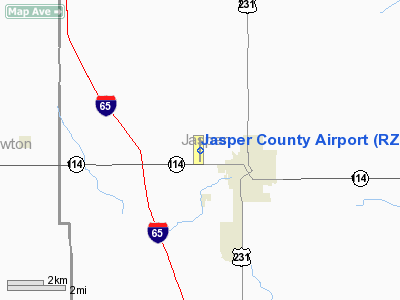
Jasper County Airport (IATA: RNZ, ICAO: KRZL, FAA LID: RZL) is a county-owned public-use airport located one nautical mile (1.8 km) northwest of the central business district of Rensselaer, a city in Jasper County, Indiana, United States.
Although most U.S. airports use the same three-letter location identifier for the FAA and IATA, this airport is assigned RZL by the FAA and RNZ by the IATA.
Facilities and aircraft
Jasper County Airport covers an area of 108 acres (44 ha) at an elevation of 698 feet (213 m) above mean sea level. It has two runways: 18/36 is 4,001 by 60 feet (1,220 x 18 m) with an asphalt pavement; 9/27 is 1,930 by 150 feet (588 x 46 m) with a turf surface.
For the 12-month period ending December 31, 2006, the airport had 8,407 aircraft operations, an average of 23 per day: 98% general aviation and 2% air taxi. At that time there were 22 aircraft based at this airport: 95% single-engine and 5% multi-engine.
The above content comes from Wikipedia and is published under free licenses – click here to read more.
|
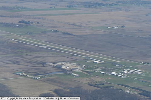 |
(Click on the photo to enlarge) |
Location
& QuickFacts
|
FAA
Information Effective: |
2008-06-05 |
|
Airport
Identifier: |
RZL |
|
Airport
Status: |
Operational |
|
Longitude/Latitude: |
087-10-57.2860W/40-56-52.4350N
-87.182579/40.947899 (Estimated) |
|
Elevation: |
698 ft / 212.75 m (Surveyed) |
|
Land: |
108 acres |
|
From nearest
city: |
1 nautical miles NW of Rensselaer, IN |
|
Location: |
Jasper County, IN |
|
Magnetic
Variation: |
02W (1990) |
Owner
& Manager
|
Ownership: |
Publicly
owned |
|
Owner: |
Jasper County Boac |
|
Address: |
2326 W. Clark St.
Rensselaer, IN 47978 |
|
Phone
number: |
219-866-5587 |
|
Manager: |
John Sjaardema |
|
Address: |
2326 W. Clark St.
Rensselaer, IN 47978 |
|
Phone
number: |
219-866-5587 |
Airport
Operations and Facilities
|
Airport
Use: |
Open
to public |
|
Wind indicator: |
Yes |
|
Segmented
Circle: |
No |
|
Control
Tower: |
No |
|
Lighting
Schedule: |
DUSK-DAWN |
|
Beacon
Color: |
Clear-Green (lighted land airport) |
|
Landing
fee charge: |
No |
|
Sectional
chart: |
Chicago |
|
Region: |
AGL - Great Lakes |
|
Boundary
ARTCC: |
ZAU - Chicago |
|
Tie-in
FSS: |
HUF - Terre Haute |
|
FSS on
Airport: |
No |
|
FSS Toll
Free: |
1-800-WX-BRIEF |
|
NOTAMs
Facility: |
HUF (NOTAM-d service avaliable) |
|
Federal
Agreements: |
NY1 |
Airport
Communications
|
CTAF: |
122.800 |
|
Unicom: |
122.800
|
Airport
Services
|
Fuel
available: |
100LLA |
|
Airframe
Repair: |
MAJOR |
|
Power
Plant Repair: |
MAJOR |
|
Bottled
Oxygen: |
NONE |
|
Bulk Oxygen: |
NONE |
|
Runway Information
Runway 09/27
|
Dimension: |
1930 x 150 ft
/ 588.3 x 45.7 m |
|
Surface: |
TURF, Good Condition |
|
|
Runway 09 |
Runway 27 |
|
Longitude: |
087-11-18.2370W |
087-10-53.0850W |
|
Latitude: |
40-56-52.1340N |
40-56-52.1340N |
|
Elevation: |
685.00 ft |
680.00 ft |
|
Alignment: |
90 |
127 |
|
Traffic
Pattern: |
Left |
Left |
|
Markings: |
None,
RWY 09 /27 THLDS HAVE ORANGE TRAFFIC CONE MARKERS. |
None, |
|
Displaced
threshold: |
0.00 ft |
130.00 ft |
|
Runway End
Identifier: |
No |
No |
|
Centerline
Lights: |
No |
No |
|
Touchdown
Lights: |
No |
No |
|
Obstruction: |
55 ft trees, 1000.0 ft from runway, 18:1 slope
to clear |
15 ft road, 305.0 ft from runway, 18:1 slope
to clear
RWY 27 APCH SLOPE 35:1 TO DISP T-HLD. |
|
Runway 18/36
|
Dimension: |
4001 x 60 ft
/ 1219.5 x 18.3 m |
|
Surface: |
ASPH, Good Condition |
|
Weight Limit: |
Single wheel: 12500 lbs. |
|
Edge Lights: |
Medium |
|
|
Runway 18 |
Runway 36 |
|
Longitude: |
087-10-53.3750W |
087-10-53.2020W |
|
Latitude: |
40-57-12.2900N |
40-56-32.7670N |
|
Elevation: |
698.00 ft |
674.00 ft |
|
Alignment: |
127 |
127 |
|
Traffic
Pattern: |
Left |
Left |
|
Markings: |
Basic, Fair Condition |
Basic, Fair Condition |
|
VASI: |
2-light PAPI on left side |
|
|
Runway End
Identifier: |
No |
No |
|
Centerline
Lights: |
No |
No |
|
Touchdown
Lights: |
No |
No |
|
Obstruction: |
26 ft road, 791.0 ft from runway, 22:1 slope
to clear |
15 ft road, 520.0 ft from runway, 21:1 slope
to clear
CLST INTCP POINT.
RWY 36 SEASONAL CROPS 120' R OF CL 0' FM RY END. TIE-DOWN
AREA 100' FM RY END 130' L OF CL. RD
245' R OF CL. |
|
Radio Navigation
Aids
|
ID |
Type |
Name |
Ch |
Freq |
Var |
Dist |
|
MCX |
NDB |
White County |
|
377.00 |
03W |
23.9 nm |
|
RWN |
NDB |
Winamac/dcmsnd |
|
335.00 |
00W |
27.6 nm |
|
VP |
NDB |
Sedly |
|
212.00 |
02W |
33.2 nm |
|
IUL |
NDB |
La Porte |
|
356.00 |
03W |
38.0 nm |
|
GGP |
NDB |
Logansport |
|
263.00 |
01W |
39.5 nm |
|
CPB |
NDB |
Culver |
|
391.00 |
01W |
39.6 nm |
|
RCR |
NDB |
Rochester |
|
216.00 |
03W |
45.6 nm |
|
MGC |
NDB |
Michigan City |
|
203.00 |
01W |
48.5 nm |
|
FKR |
NDB |
Frankfort |
|
278.00 |
02W |
49.6 nm |
|
IKK |
VOR/DME |
Kankakee |
053X |
111.60 |
00E |
31.2 nm |
|
OXI |
VOR/DME |
Knox |
103X |
115.60 |
00E |
33.0 nm |
|
RBS |
VOR/DME |
Roberts |
115X |
116.80 |
02E |
49.8 nm |
|
BVT |
VORTAC |
Boiler |
098X |
115.10 |
01E |
24.1 nm |
|
EON |
VORTAC |
Peotone |
079X |
113.20 |
02E |
33.7 nm |
|
CGT |
VORTAC |
Chicago Heights |
089X |
114.20 |
02E |
38.1 nm |
|
DNV |
VORTAC |
Danville |
047X |
111.00 |
02E |
42.9 nm |
Based Aircraft
|
Aircraft
based on field: |
20 |
|
Single Engine
Airplanes: |
19 |
|
Multi Engine Airplanes: |
1 |
Operational Statistics
Time
Period: 2006-01-01 - 2006-12-31
|
Aircraft
Operations: |
162/Week |
|
Air Taxi: |
2.0% |
|
General Aviation
Local: |
65.0% |
|
General Aviation
Itinerant: |
33.0% |
Jasper County Airport
Address:
Jasper County, IN
Tel:
219-866-5587
Images
and information placed above are from
http://www.airport-data.com/airport/RZL/
We
thank them for the data!
| General
Info |
| Country |
United
States |
| State |
INDIANA
|
| FAA ID |
RZL |
| Latitude |
40-56-52.435N
|
| Longitude |
087-10-57.286W
|
| Elevation |
698 feet
|
| Near City |
RENSSELAER
|
We don't guarantee the information is fresh and accurate. The data may
be wrong or outdated.
For more up-to-date information please refer to other sources.
|
|


