 |
|
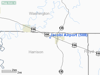
Location
& QuickFacts
|
FAA
Information Effective: |
2008-06-05 |
|
Airport
Identifier: |
5II8 |
|
Airport
Status: |
Operational |
|
Longitude/Latitude: |
086-07-43.9110W/38-24-36.2230N
-86.128864/38.410062 (Estimated) |
|
Elevation: |
750 ft / 228.60 m (Estimated) |
|
Land: |
4 acres |
|
From nearest
city: |
1 nautical miles W of Palmyra, IN |
|
Location: |
Harrison County, IN |
|
Magnetic
Variation: |
02W (1985) |
Owner
& Manager
|
Ownership: |
Privately
owned |
|
Owner: |
Phillip H. Jacobi |
|
Address: |
Highway 150 West
Palmyra, IN 47164 |
|
Phone
number: |
812-364-6141 |
|
Manager: |
Todd Uhl |
|
Address: |
Rt 1, Box 71
Palmyra, IN 47164 |
|
Phone
number: |
812-364-4417 |
Airport
Operations and Facilities
|
Airport
Use: |
Private |
|
Wind indicator: |
No |
|
Segmented
Circle: |
No |
|
Control
Tower: |
No |
|
Sectional
chart: |
St Louis |
|
Region: |
AGL - Great Lakes |
|
Boundary
ARTCC: |
ZID - Indianapolis |
|
Tie-in
FSS: |
HUF - Terre Haute |
|
FSS on
Airport: |
No |
|
FSS Toll
Free: |
1-800-WX-BRIEF |
|
Runway Information
Runway E/W
|
Dimension: |
1800 x 100 ft
/ 548.6 x 30.5 m |
|
Surface: |
TURF, |
|
|
Runway E |
Runway W |
|
Traffic
Pattern: |
Left |
Left |
|
Obstruction: |
15 ft road |
|
|
Radio Navigation
Aids
|
ID |
Type |
Name |
Ch |
Freq |
Var |
Dist |
|
RRJ |
NDB |
Oranj |
|
368.00 |
02W |
20.1 nm |
|
GOI |
NDB |
Godman |
|
396.00 |
02W |
28.1 nm |
|
EQZ |
NDB |
Captain |
|
308.00 |
02W |
28.4 nm |
|
BFR |
NDB |
Bedford |
|
344.00 |
02W |
29.6 nm |
|
FNZ |
NDB |
Ferdinand |
|
239.00 |
00E |
34.8 nm |
|
TEL |
NDB |
Tell City |
|
206.00 |
02W |
35.6 nm |
|
IMS |
NDB |
Madison |
|
404.00 |
03W |
37.8 nm |
|
BM |
NDB |
Claye |
|
382.00 |
02W |
44.7 nm |
|
BRY |
NDB |
Bardstown/dcmsnd |
|
248.00 |
02W |
45.5 nm |
|
OVO |
NDB |
North Vernon |
|
374.00 |
02W |
45.7 nm |
|
MYS |
VOR |
Mystic |
|
108.20 |
01W |
31.5 nm |
|
BQM |
VOR/DME |
Bowman |
059X |
112.20 |
01W |
24.4 nm |
|
FTK |
VOR/DME |
Fort Knox |
033X |
109.60 |
01W |
31.1 nm |
|
HNB |
VOR/DME |
Huntingburg |
029X |
109.20 |
00E |
40.2 nm |
|
ABB |
VORTAC |
Nabb |
071X |
112.40 |
01E |
25.6 nm |
|
IIU |
VORTAC |
Louisville |
095X |
114.80 |
01E |
31.9 nm |
|
OOM |
VORTAC |
Hoosier |
039X |
110.20 |
02W |
49.6 nm |
|
SDF |
VOT |
Louisville Standifd |
|
111.00 |
|
23.2 nm |
Remarks
- PRVD
THRS ARE LCTD OR DSPLCD TO PRVD 20:1 APCH SFC SLOPE OVER ALL OBSTNS.
Jacobi Airport
Address:
Harrison County, IN
Tel:
812-364-6141,
812-364-4417
Images
and information placed above are from
http://www.airport-data.com/airport/5II8/
We
thank them for the data!
| General
Info |
| Country |
United
States |
| State |
INDIANA
|
| FAA ID |
5II8 |
| Latitude |
38-24-36.223N
|
| Longitude |
086-07-43.911W
|
| Elevation |
750 feet
|
| Near City |
PALMYRA
|
We don't guarantee the information is fresh and accurate. The data may
be wrong or outdated.
For more up-to-date information please refer to other sources.
|
|


