|
 |
|
||||
|
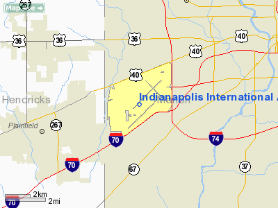
Indianapolis International Airport (IATA: IND, ICAO: KIND, FAA LID: IND) is a public airport located seven miles (11 km) southwest of the central business district of Indianapolis, a city in Marion County, Indiana, United States. It is owned and operated by the Indianapolis Airport Authority. The airport is the largest in Indiana, occupying approximately 7,700 acres (3,116 ha) of land in Wayne and Decatur Townships of Marion County, all within the city of Indianapolis. It is located near interstate highways I-65, I-69, I-70, and I-74, all of which connect to the city's I-465 beltway. Indianapolis International Airport serves as a hub for FedEx Express and a focus city for AirTran Airways. The airport averages 163 daily flights to 37 destinations. It is the eighth largest cargo center in the U.S., the 21st busiest airport in the world by cargo traffic, and FedEx's second-largest airport operation. More than 2.2 billion pounds of cargo were managed at IND in 2008. The airport's passenger terminal was the first designed and built in the United States since the terror attacks on September 11, 2001. HistoryBefore it got its International designation in 1975, Indianapolis's primary commercial air passenger and cargo facility was called Weir-Cook Municipal Airport, after Col. Harvey Weir-Cook of Wilkinson, Indiana, who was a US Army Air Forces pilot in World War I and World War II, where he was killed while flying a P-39 over New Caledonia. He became a flying ace during WWI, with seven victories. The airport opened in 1931 and its name was changed to Weir-Cook in 1944. Since 1962 it has been owned and operated by the Indianapolis Airport Authority (IAA), an eight-member governing board with members appointed by the Mayor of Indianapolis and certain other officials from Marion, Hendricks, and Hamilton counties in central Indiana. The present name was bestowed by the IAA in 1976. In the summer of 2008, the IAA's board approved a resolution retaining the current airport name but designating the new main passenger facility as the Col. H. Weir Cook Terminal. In the same resolution, the new main airport entrance road was also given the name of Col. H. Weir Cook Memorial Drive. For 51 years, between 1957 and 2008, the main passenger terminal was located on the eastern end of the airfield off High School Road. This now-closed facility was renovated and expanded many times during its lifespan, most notably in 1968 (Concourses A & B), 1972 (Concourse D), and 1987 (Concourse C and the attached Parking Garage). This entire complex, along with the separate International Arrivals Terminal (opened in 1976) located on the north side of the airfield (off Pierson Drive), became obsolete once the new Col. H. Weir Cook Terminal commenced operations on November 12, 2008. The Indianapolis Airport Authority maintains some office facilities in a portion of the old structure, but the majority of that former terminal building is expected to eventually be demolished. During the late 1980s and early 1990s, USAir (now US Airways) maintained a secondary hub in Indianapolis, with non-stop jet service to the west coast, east coast, and Florida, as well as turbo-prop service to cities throughout the Midwest. With a peak of 146 daily departures during this era, USAir was the dominant carrier, accounting for 49% of all seats. In the late 1990s, that airline chose to substantially reduce its service out of Indianapolis and discontinue the hub. In the late 1990s and early 2000s, Indianapolis International Airport became a hub for then locally-based ATA Airlines and its regional affiliate, Chicago Express/ATA Connection. However, after that airline entered Chapter 11 bankruptcy protection in late 2004, operations at IND were drastically cut, and service in Indianapolis was totally eliminated by its new, out-of-state owners in 2006. ATA's demise at IND gave Northwest Airlines an opportunity to greatly expand its operations at the airport. This service expansion allowed Indianapolis to become a focus city for that air carrier, which itself became a wholly-owned but separately operated subsidiary of Delta Air Lines in late 2008. It is not currently known how the eventual integration of Northwest into Delta will affect the combined carrier's total number of flights at IND and the focus city designation. In 1994, BAA was awarded a 10 year contract to manage the Indianapolis International Airport. The contract was later extended three additional years but subsequently was cut a year short at the request of the BAA. Private management ended on December 31, 2007 and control was transitioned back to IAA management. In the same year (1994), United Airlines finished building Indianapolis Maintenance Center, at a cost of $USD 600 million. United later moved their maintenance operations to other locations. In 2009, Republic Airways announced they would retain their maintenance hub and HQ in Indianapolis, even though they have acquired the much larger Frontier Airlines, located in Denver. Colonel H. Weir Cook Terminal
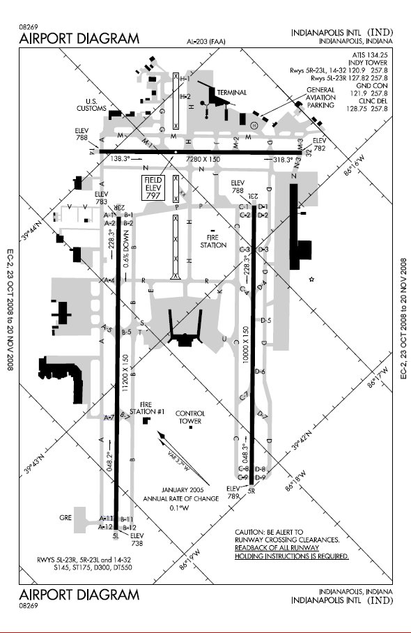
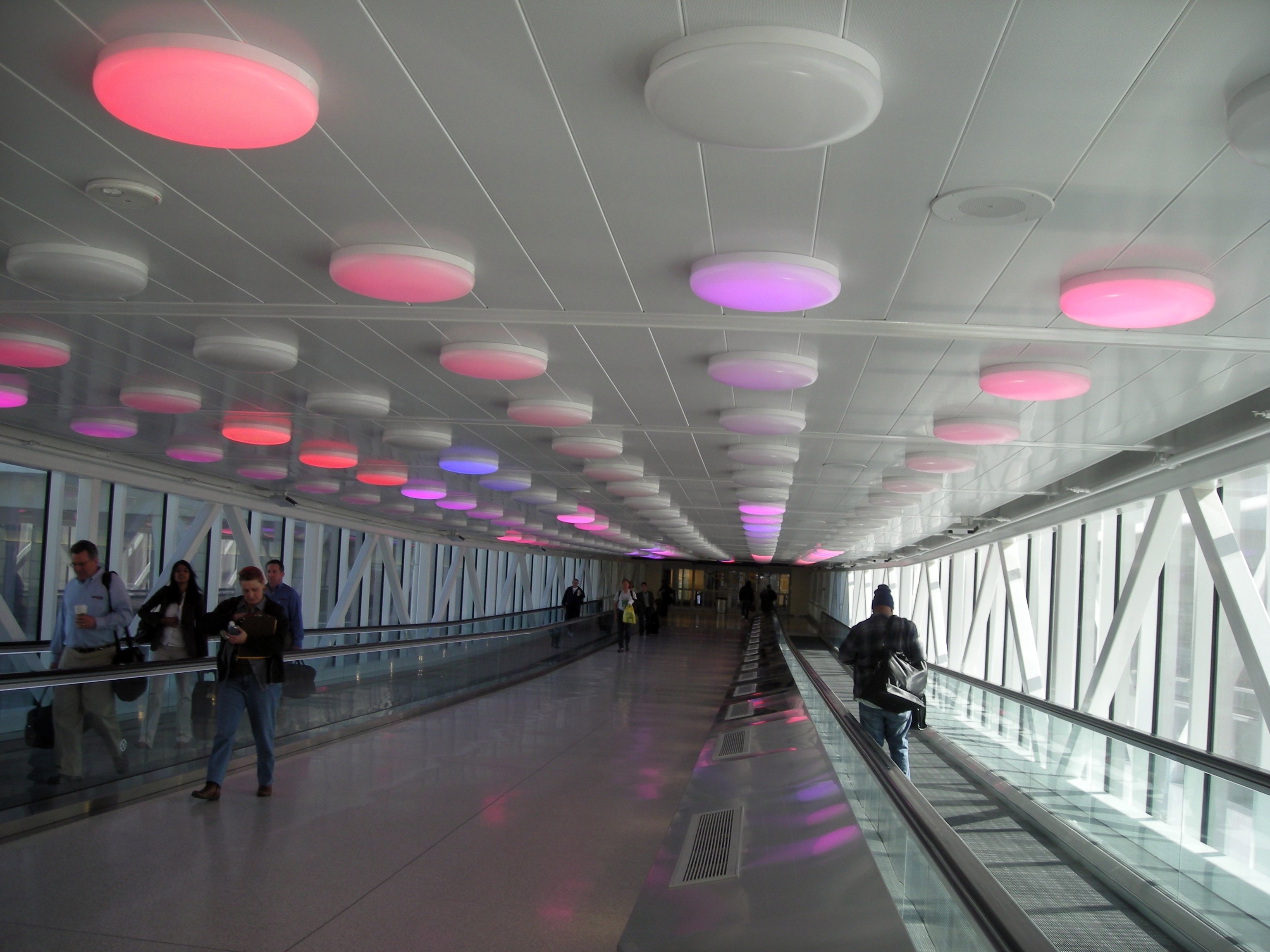
A state-of-the-art, 1,200,000-square-foot (111,000 m) midfield passenger terminal has been constructed between Indianapolis International Airport's two main parallel runways, to the southwest of the previous terminal and the crosswind runway. A new FAA Air Traffic Control Tower (ATCT) and Terminal Radar Approach Control (TRACON) building, 3rd tallest in the United States, opened in April 2006, becoming the first component of the long-planned midfield complex. The Weir Cook Terminal itself opened for arriving flights on the evening of November 11, 2008 and for departures the following morning. HOK was its master designer, with AeroDesign Group serving as architect of record. Aviation Capital Management (Indianapolis) is the airport's program manager. The new terminal, named in honor of Col. Harvey Weir-Cook, contains up to 44 domestic gate positions and 2 international gates (which can also function as domestic gates). Not all gate positions were being used upon opening of the facility, to allow for future expansion by the airlines. In addition, the two gate concourse structures were built to allow for possible future expansion on their respective southwestern ends (which is why gates A1-A2 and B1-B2 do not currently exist in the new facility). For the first time in the history of Indianapolis International Airport, international arrivals are able to be processed through customs in the main passenger terminal. Passengers arriving at gates A4 and A5 will proceed down to the U.S. Customs and Federal Inspection Station on the arrivals level via a dedicated and secured stairway, escalator, or elevator. After clearing customs, they will exit directly into the southern end of the main terminal's domestic baggage claim area. The A concourse will be receiving a new Delta Sky Club. This will be the first airline lounge at Indianapolis International Airport since US Air closed their lounge following the closure of their hub. The opening date has not yet been made public. Eight rental car operations and the Ground Transportation Center (where information about limousine, shuttle bus, hotel courtesy vehicles and other transportation services such as IndyGo bus service can be obtained) are located on the first floor of the attached parking garage. All pick-ups and drop-offs of rental vehicles also occur here, eliminating the need for shuttling customers to and from individual companies' remote processing facilities. The five-floor parking garage covers 11 acres (45,000 m) on each of its levels. It features a light-filled center atrium complete with a piece of suspended artwork and contains moving sidewalks to speed pedestrians into and out of the terminal building itself. The airport's long-range master plan also calls for a fourth (third parallel) runway to be built southeast of I-70 at some point in the future. Between 2002 and 2004, the Indiana Department of Transportation (INDOT) realigned and rebuilt a portion of this Interstate highway running through the south end of the airport's property. The reconfigured freeway was constructed to allow a future taxiway bridge serving the proposed fourth runway to cross overhead, as well as to provide a new traffic interchange to serve the then under construction midfield terminal complex. This I-70 exit (#68) is now the airport's main entrance, replacing the former entrance at Sam Jones (née Airport) Expressway and High School Road. Provisions have also been made to allow for future Light Rail Transit (LRT) access to the Weir Cook terminal complex.[1] AccidentsOn September 9, 1969, Allegheny Airlines Flight 853, which was flying a Boston - Baltimore - Cincinnati - Indianapolis - St. Louis route, was involved in a midair collision with a Piper Cherokee during its descent over Fairland, Indiana in Shelby County. The airliner, a McDonnell Douglas DC-9-31, crashed into a cornfield near London, Indiana, killing the 78 passengers and 4 crew members on board. The student pilot who was flying the Cherokee was also killed, bringing the total death toll to 83. On October 20, 1987, a United States Air Force A-7D Corsair II crashed into a Ramada Inn near the airport after the pilot was forced to eject due to a engine malfunction. Ten people were killed, nine of them hotel employees. On October 31, 1994, American Eagle Flight 4184, which was flying to Chicago, Illinois's O'Hare International Airport from Indianapolis, crashed into a soybean field near the northwestern Indiana town of Roselawn, killing all 68 on board. Other Cities ServedIndianapolis International Airport serves many nearby small and mid-sized cities, including the locations of Indiana's largest universities. Cities to which Indianapolis International Airport is the nearest major commercial airport include:
Airlines and destinations
Cargo airlines
Public transportationIndyGo operates the Green Line Downtown/Airport Express daily from 5am to 9pm. From 5am to 9am and noon to 9pm the service runs every 15 minutes. From 9am to noon the service runs every 20 minutes. The express service costs $7 per passenger. The boarding/debarking point for this service at the airport is located at the northwest end of the Ground Transportation Center, which is found on level 1 of the parking garage. The terminal was built with a Light Rail System in mind that in the future could serve this airport. IndyGo Route 8 bus also connects the airport with downtown Indianapolis. Unlike the Green Line Express, Route 8 bus is a slower & cheaper bus route that makes frequent stops along Washington St. The fare for Route 8 is currently $1.75 for single ride, same as other IndyGo buses. The above content comes from Wikipedia and is published under free licenses – click here to read more.
Runway InformationRunway 05L/23R
Runway 05R/23L
Runway 14/32
Radio Navigation Aids
Remarks
Based Aircraft
Major Carriers Serving This Airport
Most Popular Destinations
Most Popular Aircraft
Operational StatisticsTime Period: 2006-01-01 - 2006-12-31
Indianapolis International Airport Address: Marion County, IN Tel: 317-487-9594 Images
and information placed above are from We thank them for the data!
We don't guarantee the information is fresh and accurate. The data may
be wrong or outdated.
|
|||||||||||||||||||||||||||||||||||||||||||||||||||||||||||||||||||||||||||||||||||||||||||||||||||||||||||||||||||||||||||||||||||||||||||||||||||||||||||||||||||||||||||||||||||||||||||||||||||||||||||||||||||||||||||||||||||||||||||||||||||||||||||||||||||||||||||||||||||||||||||||||||||||||||||||||||||||||||||||||||||||||||||||||||||||||||||||||||||||||||||||||||||||||||||||||||||||||||||||||||||||||||||||||||||||||||||||||||||||||||||||||||||||||||||||||||||||||||||||||||||||||||||||||||||||||||||||||||||||||||||||||||||||||||||||||||||||||||||||||||||||||||||||||||||||||||||||||||||||||||||||||||||||||||||||||||||||||||||||||||||||||||||||||||||||||||||||||||||||||||||||||||||||||||||||

 |
|
Copyright 2004-2026 © by Airports-Worldwide.com, Vyshenskoho st. 36, Lviv 79010, Ukraine Legal Disclaimer |