 |
|
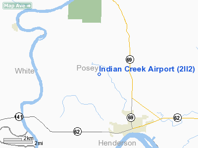
Location
& QuickFacts
|
FAA
Information Effective: |
2008-06-05 |
|
Airport
Identifier: |
2II2 |
|
Airport
Status: |
Operational |
|
Longitude/Latitude: |
087-56-18.1020W/37-59-15.1610N
-87.938362/37.987545 (Estimated) |
|
Elevation: |
380 ft / 115.82 m (Estimated) |
|
Land: |
0 acres |
|
From nearest
city: |
5 nautical miles NW of Mount Vernon, IN |
|
Location: |
Posey County, IN |
|
Magnetic
Variation: |
00E (1985) |
Owner
& Manager
|
Ownership: |
Privately
owned |
|
Owner: |
Jon Saltzman |
|
Address: |
Rr 3
Mount Vernon, IN 47620 |
|
Phone
number: |
812-838-6704 |
|
Address: |
|
Airport
Operations and Facilities
|
Airport
Use: |
Private |
|
Segmented
Circle: |
No |
|
Control
Tower: |
No |
|
Sectional
chart: |
Chicago |
|
Region: |
AGL - Great Lakes |
|
Boundary
ARTCC: |
ZID - Indianapolis |
|
Tie-in
FSS: |
HUF - Terre Haute |
|
FSS on
Airport: |
No |
|
FSS Toll
Free: |
1-800-WX-BRIEF |
|
Runway Information
Runway E/W
|
Dimension: |
2800 x 100 ft
/ 853.4 x 30.5 m |
|
Surface: |
TURF, |
|
|
Runway E |
Runway W |
|
Traffic
Pattern: |
Left |
Left |
|
Radio Navigation
Aids
|
ID |
Type |
Name |
Ch |
Freq |
Var |
Dist |
|
CUL |
NDB |
Carmi |
|
332.00 |
01W |
10.7 nm |
|
GVA |
NDB |
Geneva |
|
224.00 |
01W |
13.6 nm |
|
PDW |
NDB |
Evansville |
|
284.00 |
00E |
19.6 nm |
|
HSB |
NDB |
Harrisburg-raleigh |
|
230.00 |
00E |
30.7 nm |
|
TWT |
NDB |
Tradewater |
|
276.00 |
00E |
31.3 nm |
|
FWC |
NDB |
Wayne County |
|
257.00 |
01E |
32.4 nm |
|
AJG |
NDB |
Mount Carmel |
|
524.00 |
02W |
38.8 nm |
|
OLY |
NDB |
Olney |
|
272.00 |
00W |
45.3 nm |
|
OEA |
NDB |
Vincennes |
|
251.00 |
00E |
46.0 nm |
|
FOA |
NDB |
Elm River |
|
353.00 |
00E |
47.6 nm |
|
SAM |
VOR/DME |
Samsville |
113X |
116.60 |
03E |
30.7 nm |
|
OWB |
VOR/DME |
Owensboro |
023X |
108.60 |
01E |
39.5 nm |
|
VNN |
VOR/DME |
Mount Vernon |
085X |
113.80 |
02E |
46.8 nm |
|
HNB |
VOR/DME |
Huntingburg |
029X |
109.20 |
00E |
49.0 nm |
|
LWV |
VOR/DME |
Lawrenceville |
025X |
108.80 |
01W |
49.6 nm |
|
PXV |
VORTAC |
Pocket City |
080X |
113.30 |
03E |
9.1 nm |
|
CCT |
VORTAC |
Central City |
035X |
109.80 |
01W |
48.5 nm |
Remarks
- DUE
TO INCOMPATIBLE ARPT TRAFFIC PATTERN AIRSPACE THAT WOULD BE ASSOCIATED
WITH INDIAN CREEK & PARRISH ARPTS.
Indian Creek Airport
Address:
Posey County, IN
Tel:
812-838-6704
Images
and information placed above are from
http://www.airport-data.com/airport/2II2/
We
thank them for the data!
| General
Info |
| Country |
United
States |
| State |
INDIANA
|
| FAA ID |
2II2 |
| Latitude |
37-59-15.161N
|
| Longitude |
087-56-18.102W
|
| Elevation |
380 feet
|
| Near City |
MOUNT
VERNON |
We don't guarantee the information is fresh and accurate. The data may
be wrong or outdated.
For more up-to-date information please refer to other sources.
|
|


