 |
|
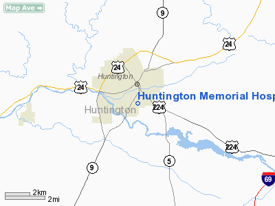
Huntington Memorial Hospital Heliport |
Location
& QuickFacts
|
FAA
Information Effective: |
2008-06-05 |
|
Airport
Identifier: |
26II |
|
Airport
Status: |
Operational |
|
Longitude/Latitude: |
085-29-42.9120W/40-52-07.1630N
-85.495253/40.868656 (Estimated) |
|
Elevation: |
730 ft / 222.50 m (Estimated) |
|
Land: |
0 acres |
|
From nearest
city: |
0 nautical miles N of Huntington, IN |
|
Location: |
Huntington County, IN |
|
Magnetic
Variation: |
03W (1985) |
Owner
& Manager
|
Ownership: |
Privately
owned |
|
Owner: |
Huntington Memorial Hospital |
|
Address: |
1215 Etna Ave
Huntington, IN 46750 |
|
Phone
number: |
219-356-3000 |
|
Manager: |
Gregory K. Sprinkle |
|
Address: |
1215 Etna Ave
Huntington, IN 46750 |
|
Phone
number: |
219-356-3000 |
Airport
Operations and Facilities
|
Airport
Use: |
Private
MEDICAL USE. |
|
Wind indicator: |
Yes |
|
Segmented
Circle: |
No |
|
Control
Tower: |
No |
|
Sectional
chart: |
Chicago |
|
Region: |
AGL - Great Lakes |
|
Boundary
ARTCC: |
ZAU - Chicago |
|
Tie-in
FSS: |
HUF - Terre Haute |
|
FSS Toll
Free: |
1-800-WX-BRIEF |
|
Runway Information
Helipad H1
|
Dimension: |
50 x 50 ft /
15.2 x 15.2 m |
|
Surface: |
TURF, |
|
|
Runway H1 |
Runway |
|
Traffic
Pattern: |
Left |
Left |
|
Radio Navigation
Aids
|
ID |
Type |
Name |
Ch |
Freq |
Var |
Dist |
|
HHG |
NDB |
Huntington |
|
417.00 |
03W |
1.6 nm |
|
IWH |
NDB |
Wabash |
|
329.00 |
03W |
15.1 nm |
|
RCR |
NDB |
Rochester |
|
216.00 |
03W |
33.7 nm |
|
PLD |
NDB |
Portland |
|
257.00 |
03W |
34.2 nm |
|
VFU |
NDB |
Stanley |
|
411.00 |
05W |
40.1 nm |
|
GGP |
NDB |
Logansport |
|
263.00 |
01W |
41.1 nm |
|
CPB |
NDB |
Culver |
|
391.00 |
01W |
45.4 nm |
|
AI |
NDB |
Video |
|
371.00 |
03W |
48.0 nm |
|
CQA |
NDB |
Lakefield |
|
205.00 |
04W |
48.4 nm |
|
ANQ |
NDB |
Angola |
|
347.00 |
05W |
49.9 nm |
|
OLK |
VOR |
Wolf Lake |
|
110.40 |
03W |
22.7 nm |
|
MZZ |
VOR/DME |
Marion |
023X |
108.60 |
03W |
24.1 nm |
|
MIE |
VOR/DME |
Muncie |
091X |
114.40 |
03W |
38.2 nm |
|
FWA |
VORTAC |
Fort Wayne |
125X |
117.80 |
00E |
15.4 nm |
|
GUS |
VORTAC |
Grissom |
21Y |
108.45 |
02W |
32.8 nm |
|
OKK |
VORTAC |
Kokomo |
082X |
113.50 |
00E |
32.8 nm |
|
GSH |
VORTAC |
Goshen |
084X |
113.70 |
00E |
46.2 nm |
|
FWA |
VOT |
Fort Wayne Baer |
|
111.00 |
|
15.3 nm |
Remarks
- PRVDD
OPNS ARE CONDUCTED FM 090 TO 105 DEGS & FM 140 TO 180 DEGS; AREA
IS MKD; WIND INDICATOR IS MAINTD.
Huntington Memorial Hospital Heliport
Address:
Huntington County, IN
Tel:
219-356-3000
Images
and information placed above are from
http://www.airport-data.com/airport/26II/
We
thank them for the data!
| General
Info |
| Country |
United
States |
| State |
INDIANA
|
| FAA ID |
26II |
| Latitude |
40-52-07.163N
|
| Longitude |
085-29-42.912W
|
| Elevation |
730 feet
|
| Near City |
HUNTINGTON
|
We don't guarantee the information is fresh and accurate. The data may
be wrong or outdated.
For more up-to-date information please refer to other sources.
|
|


