|
|
| Hobart Sky Ranch Airport |
| IATA: none – ICAO: none – FAA LID: 3HO |
| Summary |
| Airport type |
Public |
| Owner |
Don Niemeyer |
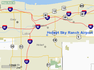
| Location |
Hobart, Indiana |
| Elevation AMSL |
644 ft / 196 m |
| Coordinates |
41°33′15″N 087°15′45″W / 41.55417°N 87.2625°W / 41.55417; -87.2625 |
| Runways |
| Direction |
Length |
Surface |
| ft |
m |
| 18/36 |
3,125 |
952 |
Asphalt |
| Source: Federal Aviation Administration |
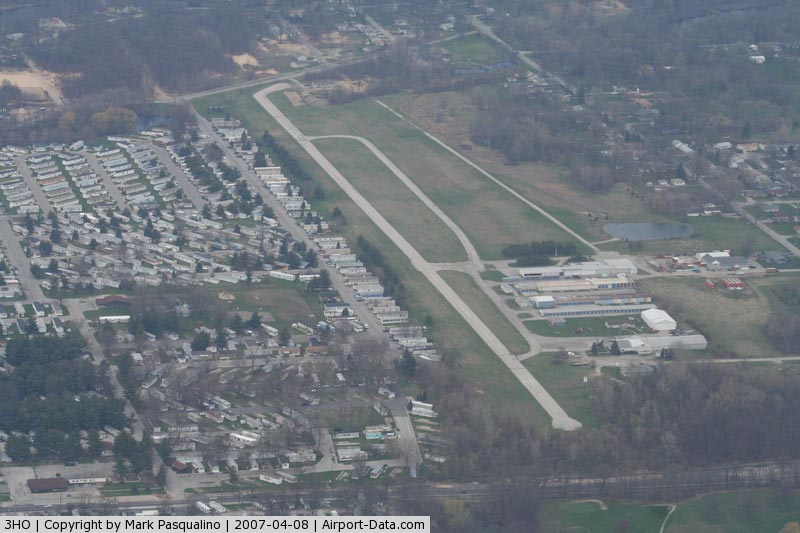
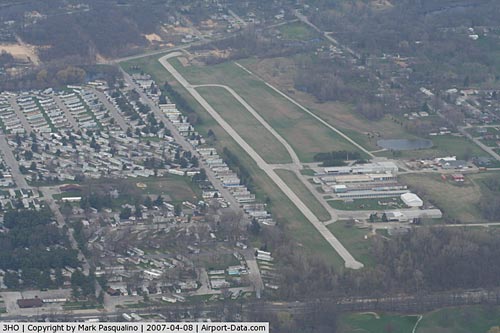
Hobart Sky Ranch Airport (FAA LID: 3HO) is a public-use airport located two miles (3 km) northwest of the central business district of Hobart, a city in Lake County, Indiana, United States. This airport is privately owned by Don Niemeyer. Facilities
Hobart Sky Ranch Airport covers an area of 28 acres (11 ha) which contains one runway:
- Runway 18/36: 3,125 x 40 ft (952 x 12 m), Surface: Asphalt
Runway
The Runway at Hobart Sky Ranch (18/36) is poorly maintained. Currently, there are cracks through out the runway/taxiway surfaces with grass growing between the cracks. The markings on the runway have faded away.
The above content comes from Wikipedia and is published under free licenses – click here to read more.
|
 |
(Click on the photo to enlarge) |
|
 |
(Click on the photo to enlarge) |
Location
& QuickFacts
|
FAA
Information Effective: |
2008-06-05 |
|
Airport
Identifier: |
3HO |
|
Airport
Status: |
Operational |
|
Longitude/Latitude: |
087-15-45.1290W/41-33-15.1320N
-87.262536/41.554203 (Estimated) |
|
Elevation: |
644 ft / 196.29 m (Estimated) |
|
Land: |
28 acres |
|
From
nearest city: |
2 nautical miles NW of Hobart, IN |
|
Location: |
Lake County, IN |
|
Magnetic Variation: |
01W (1985) |
Owner
& Manager
|
Ownership: |
Privately
owned |
|
Owner: |
Don Niemeyer |
|
Address: |
3600 N Lake Park Avenue
Hobart, IN 46342 |
|
Phone
number: |
219-962-3020 |
|
Manager: |
Don Niemeyer |
|
Address: |
3600 N Lake Park Avenue
Hobart, IN 46342 |
|
Phone number: |
219-962-3020 |
Airport Operations and Facilities
|
Airport
Use: |
Open
to public |
|
Wind
indicator: |
Yes |
|
Segmented Circle: |
No |
|
Control
Tower: |
No |
|
Landing
fee charge: |
No |
|
Sectional chart: |
Chicago |
|
Region: |
AGL - Great Lakes |
|
Boundary
ARTCC: |
ZAU - Chicago |
|
Tie-in
FSS: |
HUF - Terre Haute |
|
FSS
on Airport: |
No |
|
FSS
Toll Free: |
1-800-WX-BRIEF |
|
NOTAMs
Facility: |
HUF (NOTAM-d service avaliable) |
Airport Communications
|
CTAF: |
122.800 |
|
Unicom: |
122.800 |
Airport Services
|
Runway Information
Runway 18/36
|
Dimension: |
3125
x 40 ft / 952.5 x 12.2 m |
|
Surface: |
ASPH, Poor Condition
CRACKS WITH GRASS GROWING THROUGH. |
|
|
Runway 18 |
Runway 36 |
|
Longitude: |
087-15-50.1200W |
087-15-50.1200W |
|
Latitude: |
41-33-36.6800N |
41-33-05.8000N |
|
Elevation: |
630.00 ft |
630.00 ft |
|
Traffic
Pattern: |
Left |
Left |
|
Markings: |
Basic, Poor Condition
18/36 MARKINGS FADED. |
Basic, Poor Condition |
|
Displaced
threshold: |
502.00 ft |
320.00 ft |
|
Runway
End Identifier: |
No |
No |
|
Centerline
Lights: |
No |
No |
|
Touchdown
Lights: |
No |
No |
|
Obstruction: |
25 ft tree, 240.0 ft from runway, 30 ft left
of centerline, 1:1 slope to clear
APCH SLOPE 29:1 AT DSPLCD THR. |
20 ft trees, 201.0 ft from runway
APCH SLOPE 18:1 AT DSPLCD THLD.
+20 FT TREES, 52 FT FM RY END BOTH SIDES OF CNTRLN. |
|
Radio Navigation
Aids
|
ID |
Type |
Name |
Ch |
Freq |
Var |
Dist |
|
VP |
NDB |
Sedly |
|
212.00 |
02W |
18.4 nm |
|
MGC |
NDB |
Michigan City |
|
203.00 |
01W |
22.0 nm |
|
MX |
NDB |
Kedzi |
|
248.00 |
01W |
22.2 nm |
|
IUL |
NDB |
La Porte |
|
356.00 |
03W |
22.3 nm |
|
HK |
NDB |
Ermin |
|
332.00 |
01W |
27.6 nm |
|
RZL |
NDB |
Rensselaer |
|
362.00 |
02W |
36.7 nm |
|
RWN |
NDB |
Winamac/dcmsnd |
|
335.00 |
00W |
40.6 nm |
|
ME |
NDB |
Deana |
|
350.00 |
00E |
42.3 nm |
|
CPB |
NDB |
Culver |
|
391.00 |
01W |
44.5 nm |
|
OXI |
VOR/DME |
Knox |
103X |
115.60 |
00E |
31.0 nm |
|
ORD |
VOR/DME |
Chicago O'hare |
086X |
113.90 |
02E |
38.8 nm |
|
IKK |
VOR/DME |
Kankakee |
053X |
111.60 |
00E |
39.2 nm |
|
CGT |
VORTAC |
Chicago Heights |
089X |
114.20 |
02E |
14.2 nm |
|
EON |
VORTAC |
Peotone |
079X |
113.20 |
02E |
29.3 nm |
|
GIJ |
VORTAC |
Gipper |
101X |
115.40 |
00E |
44.3 nm |
|
JOT |
VORTAC |
Joliet |
070X |
112.30 |
02E |
47.5 nm |
|
MDW |
VOT |
Chicago Midway |
|
111.00 |
|
26.0 nm |
|
ORD |
VOT |
Chicago O'hare Intl |
|
112.00 |
|
38.7 nm |
Remarks
- TRAILER
PARK 155' WEST OF RY.
- PHONE
AVBL INSIDE 24-HRS.
- EXISTED
PRIOR TO 1959.
Based Aircraft
|
Aircraft
based on field: |
7 |
|
Single
Engine Airplanes: |
6 |
|
Multi
Engine Airplanes: |
1 |
Operational Statistics
Time Period: 2005-07-25 - 2006-07-24
|
Aircraft
Operations: |
118/Week |
|
Air
Taxi: |
0.7% |
|
General
Aviation Local: |
60.0% |
|
General
Aviation Itinerant: |
39.3% |
Hobart Sky Ranch Airport
Address:
Lake County, IN
Tel:
219-962-3020
Images
and information placed above are from
http://www.airport-data.com/airport/3HO/
We
thank them for the data!
| General
Info |
| Country |
United
States |
| State |
INDIANA
|
| FAA ID |
3HO |
| Latitude |
41-33-15.132N
|
| Longitude |
087-15-45.129W
|
| Elevation |
644 feet
|
| Near City |
HOBART
|
We don't guarantee the information is fresh and accurate. The data may
be wrong or outdated.
For more up-to-date information please refer to other sources.
|
|