 |
|
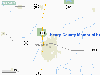
Henry County Memorial Hospital Heliport |
Location
& QuickFacts
|
FAA
Information Effective: |
2008-06-05 |
|
Airport
Identifier: |
19II |
|
Airport
Status: |
Operational |
|
Longitude/Latitude: |
085-21-52.8900W/39-56-35.1660N
-85.364692/39.943102 (Estimated) |
|
Elevation: |
1052 ft / 320.65 m (Estimated) |
|
Land: |
0 acres |
|
From nearest
city: |
0 nautical miles S of New Castle, IN |
|
Location: |
Henry County, IN |
|
Magnetic
Variation: |
03W (1990) |
Owner
& Manager
|
Ownership: |
Privately
owned |
|
Owner: |
Henry County Memorial Hosp. |
|
Address: |
1000 N 16 St.
New Castle, IN 47362 |
|
Phone
number: |
317-521-0890 |
|
Manager: |
Charles Butler |
|
Address: |
1000 N 16 Street
New Castel, IN 47362 |
|
Phone
number: |
317-521-1501 |
Airport
Operations and Facilities
|
Airport
Use: |
Private
MEDICAL USE |
|
Wind indicator: |
Yes |
|
Segmented
Circle: |
No |
|
Control
Tower: |
No |
|
Sectional
chart: |
St Louis |
|
Region: |
AGL - Great Lakes |
|
Boundary
ARTCC: |
ZID - Indianapolis |
|
Tie-in
FSS: |
HUF - Terre Haute |
|
FSS Toll
Free: |
1-800-WX-BRIEF |
|
Runway Information
Helipad H1
|
Dimension: |
30 x 30 ft /
9.1 x 9.1 m |
|
Surface: |
CONC, |
|
|
Runway H1 |
Runway |
|
Traffic
Pattern: |
Left |
Left |
|
Radio Navigation
Aids
|
ID |
Type |
Name |
Ch |
Freq |
Var |
Dist |
|
UWL |
NDB |
New Castle |
|
385.00 |
02W |
4.3 nm |
|
AI |
NDB |
Video |
|
371.00 |
03W |
10.1 nm |
|
UMP |
NDB |
Metropolitan |
|
338.00 |
03W |
31.6 nm |
|
PLD |
NDB |
Portland |
|
257.00 |
03W |
35.3 nm |
|
HLB |
NDB |
Batesville |
|
254.00 |
02W |
36.0 nm |
|
OXD |
NDB |
Oxford |
|
282.00 |
04W |
37.6 nm |
|
HFY |
NDB |
Greenwood |
|
398.00 |
02W |
38.4 nm |
|
HZP |
NDB |
Zionsville |
|
248.00 |
03W |
40.8 nm |
|
VES |
NDB |
Versailles |
|
356.00 |
04W |
41.8 nm |
|
BA |
NDB |
Clifs |
|
410.00 |
03W |
42.8 nm |
|
CQA |
NDB |
Lakefield |
|
205.00 |
04W |
49.0 nm |
|
MIE |
VOR/DME |
Muncie |
091X |
114.40 |
03W |
17.7 nm |
|
MZZ |
VOR/DME |
Marion |
023X |
108.60 |
03W |
36.1 nm |
|
DQN |
VOR/DME |
Dayton |
092X |
114.50 |
01W |
44.8 nm |
|
RID |
VORTAC |
Richmond |
043X |
110.60 |
03W |
26.8 nm |
|
SHB |
VORTAC |
Shelbyville |
057X |
112.00 |
01E |
28.3 nm |
|
VHP |
VORTAC |
Brickyard |
110X |
116.30 |
01E |
46.9 nm |
|
OKK |
VORTAC |
Kokomo |
082X |
113.50 |
00E |
47.4 nm |
|
IND |
VOT |
Indianapolis Intl |
|
109.60 |
|
44.4 nm |
Remarks
- ALL
OPERATIONS ARE FROM 150 DEG TO 210 DEG & FROM 65 DEG TO 76 DEG;
AREA IS MARKED; WIND INDICATOR IS MAINTAINED.
Henry County Memorial Hospital Heliport
Address:
Henry County, IN
Tel:
317-521-0890,
317-521-1501
Images
and information placed above are from
http://www.airport-data.com/airport/19II/
We
thank them for the data!
| General
Info |
| Country |
United
States |
| State |
INDIANA
|
| FAA ID |
19II |
| Latitude |
39-56-35.166N
|
| Longitude |
085-21-52.890W
|
| Elevation |
1052 feet
|
| Near City |
NEW CASTLE
|
We don't guarantee the information is fresh and accurate. The data may
be wrong or outdated.
For more up-to-date information please refer to other sources.
|
|


