 |
|
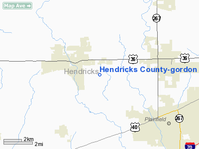
Hendricks County - Gordon Graham Field Airport |
Coordinates: 39°44â²48â³N 086°28â²31â³W / 39.74667°N 86.47528°W / 39.74667; -86.47528
Hendricks County Airport
Gordon Graham Field |
| IATA: none â ICAO: none â FAA LID: 2R2 |
| Summary |
| Airport type |
Public |
| Owner |
Indianapolis Airport Authority |
| Serves |
Indianapolis, Indiana |
| Location |
Danville, Indiana |
| Elevation AMSL |
897 ft / 273 m |
| Runways |
| Direction |
Length |
Surface |
| ft |
m |
| 18/36 |
4,400 |
1,341 |
Asphalt |
| Statistics (2006) |
| Aircraft operations |
6,853 |
| Based aircraft |
47 |
| Source: FAA and airport web page |
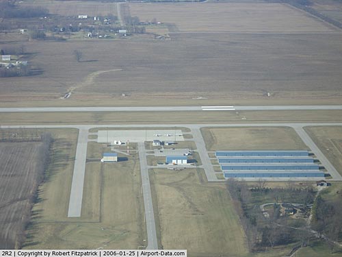
Hendricks County Airport (FAA LID: 2R2), also known as Gordon Graham Field, is a public airport at 2749 Gordon Graham Blvd. in Danville, a town in Hendricks County, Indiana, United States. Owned by the Indianapolis Airport Authority, it is located 13 miles (21 km) west of the central business district of Indianapolis and serves as a reliever airport for Indianapolis International Airport. The airport is also two miles (3 km) southeast from the center of Danville.
Facilities and aircraft
Hendricks County-Gordon Graham Field covers an area of 239 acres (97 ha) which contains one runway designated 18/36 with a 4,400 x 100 ft (1,341 x 30 m) asphalt pavement. For the 12-month period ending October 16, 2006, the airport had 6,853 aircraft operations, an average of 18 per day: 93% general aviation, 3% air taxi and 4% military. There are 47 aircraft based at this airport: 96% single-engine, 2% multi-engine and 2% helicopter.
The above content comes from Wikipedia and is published under free licenses – click here to read more.
|
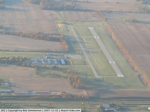 |
(Click on the photo to enlarge) |
|
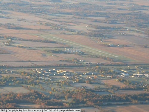 |
(Click on the photo to enlarge) |
|
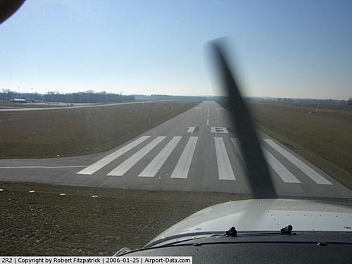 |
(Click on the photo to enlarge) |
|
 |
(Click on the photo to enlarge) |
Location
& QuickFacts
|
FAA
Information Effective: |
2008-06-05 |
|
Airport
Identifier: |
2R2 |
|
Airport
Status: |
Operational |
|
Longitude/Latitude: |
086-28-30.6000W/39-44-48.4000N
-86.475167/39.746778 (Estimated) |
|
Elevation: |
897 ft / 273.41 m (Surveyed) |
|
Land: |
239 acres |
|
From nearest
city: |
13 nautical miles W of Indianapolis, IN |
|
Location: |
Hendricks County, IN |
|
Magnetic
Variation: |
03W (1965) |
Owner
& Manager
|
Ownership: |
Publicly
owned |
|
Owner: |
Indianapolis Airport Authority |
|
Address: |
2500 S High School Rd Ste 100
Indianapolis, IN 46241 |
|
Phone
number: |
317-487-5024 |
|
Manager: |
Michael Medvescek |
|
Address: |
2500 S High School Rd Ste 100
Indianapolis, IN 46241 |
|
Phone
number: |
317-487-5024 |
Airport
Operations and Facilities
|
Airport
Use: |
Open
to public |
|
Wind indicator: |
Yes |
|
Segmented
Circle: |
Yes |
|
Control
Tower: |
No |
|
Lighting
Schedule: |
RDO-CTL
MIRL RY 18/36 PRESET ON LOW INTST TO INCR INTST ACTVT -
CTAF. |
|
Beacon
Color: |
Clear-Green (lighted land airport) |
|
Sectional
chart: |
St Louis |
|
Region: |
AGL - Great Lakes |
|
Boundary
ARTCC: |
ZID - Indianapolis |
|
Tie-in
FSS: |
HUF - Terre Haute |
|
FSS Toll
Free: |
1-800-WX-BRIEF |
|
NOTAMs
Facility: |
HUF (NOTAM-d service avaliable) |
|
Federal
Agreements: |
N |
Airport
Communications
|
CTAF: |
122.700 |
|
Unicom: |
122.700
|
Airport
Services
|
Runway Information
Runway 18/36
|
Dimension: |
4400 x 100 ft
/ 1341.1 x 30.5 m |
|
Surface: |
ASPH, Good Condition |
|
Edge Lights: |
Medium |
|
|
Runway 18 |
Runway 36 |
|
Longitude: |
086-28-30.4128W |
086-28-30.8137W |
|
Latitude: |
39-45-10.1835N |
39-44-26.7133N |
|
Elevation: |
897.00 ft |
864.00 ft |
|
Traffic
Pattern: |
Left |
Left |
|
Markings: |
Non-precision instrument, Good Condition |
Non-precision instrument, Good Condition |
|
Crossing
Height: |
38.00 ft |
38.00 ft |
|
VASI: |
2-light PAPI on left side |
2-light PAPI on left side |
|
Visual Glide
Angle: |
3.00° |
3.00° |
|
Runway End
Identifier: |
Yes |
Yes |
|
Obstruction: |
21 ft trees, 1072.0 ft from runway, 41:1 slope
to clear |
11 ft pline, 726.0 ft from runway, 47:1 slope
to clear |
|
Radio Navigation
Aids
|
ID |
Type |
Name |
Ch |
Freq |
Var |
Dist |
|
TVX |
NDB |
Greencastle |
|
521.00 |
03W |
15.4 nm |
|
HZP |
NDB |
Zionsville |
|
248.00 |
03W |
15.6 nm |
|
HFY |
NDB |
Greenwood |
|
398.00 |
02W |
19.1 nm |
|
UMP |
NDB |
Metropolitan |
|
338.00 |
03W |
22.7 nm |
|
CFJ |
NDB |
Crawfordsville |
|
388.00 |
02W |
24.7 nm |
|
FKR |
NDB |
Frankfort |
|
278.00 |
02W |
31.7 nm |
|
BA |
NDB |
Clifs |
|
410.00 |
03W |
39.7 nm |
|
BM |
NDB |
Claye |
|
382.00 |
02W |
41.9 nm |
|
HU |
NDB |
Yinno |
|
245.00 |
02W |
47.9 nm |
|
AI |
NDB |
Video |
|
371.00 |
03W |
48.5 nm |
|
VHP |
VORTAC |
Brickyard |
110X |
116.30 |
01E |
6.4 nm |
|
SHB |
VORTAC |
Shelbyville |
057X |
112.00 |
01E |
30.9 nm |
|
OOM |
VORTAC |
Hoosier |
039X |
110.20 |
02W |
36.8 nm |
|
TTH |
VORTAC |
Terre Haute |
100X |
115.30 |
02E |
39.0 nm |
|
IND |
VOT |
Indianapolis Intl |
|
109.60 |
|
9.0 nm |
Based Aircraft
|
Aircraft
based on field: |
47 |
|
Single Engine
Airplanes: |
45 |
|
Multi Engine Airplanes: |
1 |
|
Helicopters: |
1 |
Operational Statistics
Time
Period: 2005-10-17 - 2006-10-16
|
Aircraft
Operations: |
132/Week |
|
Air Taxi: |
2.8% |
|
General Aviation
Local: |
49.7% |
|
General Aviation
Itinerant: |
43.6% |
|
Military: |
3.8% |
Hendricks County-gordon Graham Field Airport
Address:
Hendricks County, IN
Tel:
317-487-5024
Images
and information placed above are from
http://www.airport-data.com/airport/2R2/
We
thank them for the data!
| General
Info |
| Country |
United
States |
| State |
INDIANA
|
| FAA ID |
2R2 |
| Latitude |
39-44-53.310N
|
| Longitude |
086-28-25.530W
|
| Elevation |
896 feet
|
| Near City |
INDIANAPOLIS
|
We don't guarantee the information is fresh and accurate. The data may
be wrong or outdated.
For more up-to-date information please refer to other sources.
|
|


