|
|
| Hagerstown Airport |
| IATA: none – ICAO: none – FAA LID: I61 |
| Summary |
| Airport type |
Public |
| Owner |
Town of Hagerstown |
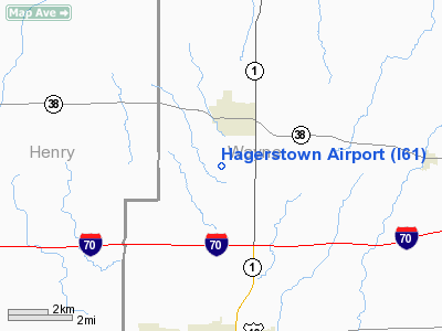
| Location |
Hagerstown, Indiana |
| Elevation AMSL |
1,000 ft / 305 m |
| Coordinates |
39°53′21″N 085°09′48″W / 39.88917°N 85.16333°W / 39.88917; -85.16333 |
| Runways |
| Direction |
Length |
Surface |
| ft |
m |
| 2/20 |
4,000 |
1,219 |
Turf |
| Source: Federal Aviation Administration |
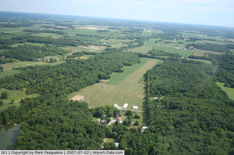
Hagerstown Airport (FAA LID: I61) is a public airport located one mile (1.6 km) south of the central business district of Hagerstown, a town in Wayne County, Indiana, United States. This airport is publicly owned by the Town of Hagerstown. Facilities
Hagerstown Airport covers an area of 80 acres (32 ha) which contains one runway:
- Runway 2/20: 4,000 x 200 ft (1,219 x 61 m), Surface: Turf
Events
On August 26, 2007 a small single engine plane skipped at the end of the runway, skidded on the wet grass and hit a fence before flipping on its back. The pilot and two sixteen year old boys on board suffered minor cuts and bruises.
The above content comes from Wikipedia and is published under free licenses – click here to read more.
|
 |
(Click on the photo to enlarge) |
Location
& QuickFacts
|
FAA
Information Effective: |
2008-06-05 |
|
Airport
Identifier: |
I61 |
|
Airport
Status: |
Operational |
|
Longitude/Latitude: |
085-09-48.0000W/39-53-21.0000N
-85.163333/39.889167 (Estimated) |
|
Elevation: |
1000 ft / 304.80 m (Estimated) |
|
Land: |
80 acres |
|
From nearest
city: |
1 nautical miles S of Hagerstown, IN |
|
Location: |
Wayne County, IN |
|
Magnetic
Variation: |
03W (1985) |
Owner
& Manager
|
Ownership: |
Publicly
owned |
|
Owner: |
Town Of Hagerstown |
|
Address: |
49 E College
Hagerstown, IN 47346 |
|
Phone
number: |
317-489-6171 |
|
Manager: |
Carl Cordell |
|
Address: |
201 E. College Street
Hagerstown, IN 47346 |
|
Phone
number: |
317-489-4621 |
Airport
Operations and Facilities
|
Airport
Use: |
Open
to public |
|
Wind indicator: |
Yes |
|
Segmented
Circle: |
No |
|
Control
Tower: |
No |
|
Lighting
Schedule: |
RDO
REQ
ACTVT LIRL RY 02/20 - CTAF. |
|
Landing
fee charge: |
No |
|
Sectional
chart: |
St Louis |
|
Region: |
AGL - Great Lakes |
|
Boundary
ARTCC: |
ZID - Indianapolis |
|
Tie-in
FSS: |
HUF - Terre Haute |
|
FSS on
Airport: |
No |
|
FSS Toll
Free: |
1-800-WX-BRIEF |
|
NOTAMs
Facility: |
HUF
(NOTAM-d service avaliable) |
Airport
Communications
|
CTAF: |
123.000 |
|
Unicom: |
123.000
|
Airport
Services
|
Airframe
Repair: |
NONE |
|
Power
Plant Repair: |
NONE |
|
Bottled
Oxygen: |
NONE |
|
Bulk Oxygen: |
NONE |
|
Runway Information
Runway 02/20
|
Dimension: |
4000 x 200 ft
/ 1219.2 x 61.0 m |
|
Surface: |
TURF, Fair Condition |
|
Edge Lights: |
Low |
|
|
Runway 02 |
Runway 20 |
|
Longitude: |
085-09-59.7700W |
085-09-42.2200W |
|
Latitude: |
39-53-01.8600N |
39-53-39.0000N |
|
Elevation: |
990.00 ft |
990.00 ft |
|
Traffic
Pattern: |
Left |
Left |
|
Displaced
threshold: |
200.00 ft
02/20 DSPLCD THLDS MKD BY LGT FIXTURES, & YELLOW TIRES. |
1070.00 ft |
|
Runway End
Identifier: |
No |
|
|
Obstruction: |
25 ft tree, 425.0 ft from runway, 17:1 slope
to clear
APCH RATIO 21:1 AT DSPLCD THLD;38 FT TREES 609 FT FM RY END. |
49 ft trees, 200.0 ft from runway, 4:1 slope
to clear
APCH SLOPE 25:1 AT DSPLCD THR. |
|
Radio Navigation
Aids
|
ID |
Type |
Name |
Ch |
Freq |
Var |
Dist |
|
UWL |
NDB |
New Castle |
|
385.00 |
02W |
7.2 nm |
|
AI |
NDB |
Video |
|
371.00 |
03W |
19.3 nm |
|
OXD |
NDB |
Oxford |
|
282.00 |
04W |
29.0 nm |
|
HLB |
NDB |
Batesville |
|
254.00 |
02W |
32.7 nm |
|
PLD |
NDB |
Portland |
|
257.00 |
03W |
34.9 nm |
|
VES |
NDB |
Versailles |
|
356.00 |
04W |
35.1 nm |
|
HKF |
NDB |
Hook Field |
|
239.00 |
04W |
40.6 nm |
|
UMP |
NDB |
Metropolitan |
|
338.00 |
03W |
41.0 nm |
|
HAO |
NDB |
Hamilton |
|
260.00 |
04W |
41.4 nm |
|
CQA |
NDB |
Lakefield |
|
205.00 |
04W |
45.0 nm |
|
HFY |
NDB |
Greenwood |
|
398.00 |
02W |
45.5 nm |
|
BA |
NDB |
Clifs |
|
410.00 |
03W |
45.6 nm |
|
MIE |
VOR/DME |
Muncie |
091X |
114.40 |
03W |
23.5 nm |
|
DQN |
VOR/DME |
Dayton |
092X |
114.50 |
01W |
36.1 nm |
|
MZZ |
VOR/DME |
Marion |
023X |
108.60 |
03W |
43.4 nm |
|
RID |
VORTAC |
Richmond |
043X |
110.60 |
03W |
17.0 nm |
|
SHB |
VORTAC |
Shelbyville |
057X |
112.00 |
01E |
34.2 nm |
|
DAY |
VOT |
Dayton J M Cox-day |
|
111.00 |
|
43.5 nm |
Remarks
Based Aircraft
|
Aircraft
based on field: |
12 |
|
Single Engine
Airplanes: |
8 |
|
Ultralights: |
4 |
Operational Statistics
Time
Period: 2006-01-01 - 2006-12-31
|
Aircraft
Operations: |
70/Week |
|
General Aviation
Local: |
37.0% |
|
General Aviation
Itinerant: |
63.0% |
Hagerstown Airport
Address:
Wayne County, IN
Tel:
317-489-6171,
317-489-4621
Images
and information placed above are from
http://www.airport-data.com/airport/I61/
We
thank them for the data!
| General
Info |
| Country |
United
States |
| State |
INDIANA
|
| FAA ID |
I61 |
| Latitude |
39-53-21.000N
|
| Longitude |
085-09-48.000W
|
| Elevation |
1000 feet
|
| Near City |
HAGERSTOWN |
We don't guarantee the information is fresh and accurate. The data may
be wrong or outdated.
For more up-to-date information please refer to other sources.
|
|