 |
|
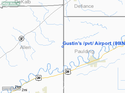
Location
& QuickFacts
|
FAA
Information Effective: |
2008-06-05 |
|
Airport
Identifier: |
80IN |
|
Airport
Status: |
Operational |
|
Longitude/Latitude: |
084-48-18.8590W/41-12-15.1790N
-84.805239/41.204216 (Estimated) |
|
Elevation: |
740 ft / 225.55 m (Estimated) |
|
Land: |
0 acres |
|
From nearest
city: |
8 nautical miles E of Harlan, IN |
|
Location: |
Allen County, IN |
|
Magnetic
Variation: |
03W (1985) |
Owner
& Manager
|
Ownership: |
Privately
owned |
|
Owner: |
Cyrus Gustin |
|
Address: |
12211 State Line Road
Harlan, IN 46743 |
|
Phone
number: |
219-657-5625 |
|
Address: |
|
Airport
Operations and Facilities
|
Airport
Use: |
Private |
|
Wind indicator: |
Yes |
|
Segmented
Circle: |
No |
|
Control
Tower: |
No |
|
Lighting
Schedule: |
PHONE REQ
FOR RWY LGTS PHONE 219-657-5625. |
|
Landing
fee charge: |
No |
|
Sectional
chart: |
Detroit |
|
Region: |
AGL - Great Lakes |
|
Boundary
ARTCC: |
ZAU - Chicago |
|
Tie-in
FSS: |
HUF - Terre Haute |
|
FSS
on Airport: |
No |
|
FSS
Toll Free: |
1-800-WX-BRIEF |
Airport
Services
|
Runway Information
Runway 17/35
|
Dimension: |
2500 x 50 ft
/ 762.0 x 15.2 m |
|
Surface: |
TURF, |
|
Edge Lights: |
Low |
|
|
Runway 17 |
Runway 35 |
|
Traffic
Pattern: |
Left |
Left |
|
Displaced
threshold: |
400.00 ft |
0.00 ft |
|
Obstruction: |
17 ft pline, 150.0 ft from runway |
|
|
Radio Navigation
Aids
|
ID |
Type |
Name |
Ch |
Freq |
Var |
Dist |
|
DFI |
NDB |
Defiance |
|
246.00 |
05W |
18.8 nm |
|
VFU |
NDB |
Stanley |
|
411.00 |
05W |
22.3 nm |
|
BYN |
NDB |
Bryan |
|
260.00 |
04W |
22.6 nm |
|
ANQ |
NDB |
Angola |
|
347.00 |
05W |
29.1 nm |
|
HHG |
NDB |
Huntington |
|
417.00 |
03W |
36.5 nm |
|
USE |
NDB |
Fulton |
|
375.00 |
05W |
38.9 nm |
|
PDR |
NDB |
Ottawa |
|
233.00 |
05W |
39.0 nm |
|
CQA |
NDB |
Lakefield |
|
205.00 |
04W |
44.8 nm |
|
PLD |
NDB |
Portland |
|
257.00 |
03W |
45.8 nm |
|
IRS |
NDB |
Sturgis |
|
382.00 |
04W |
46.3 nm |
|
LYL |
NDB |
Lima |
|
362.00 |
04W |
46.5 nm |
|
OLK |
VOR |
Wolf Lake |
|
110.40 |
03W |
31.4 nm |
|
AOH |
VOR |
Allen County |
|
108.40 |
04W |
48.3 nm |
|
FWA |
VORTAC |
Fort Wayne |
125X |
117.80 |
00E |
22.0 nm |
|
FDY |
VORTAC |
Findlay |
019X |
108.20 |
02W |
49.8 nm |
|
FWA |
VOT |
Fort Wayne Baer |
|
111.00 |
|
22.1 nm |
Based Aircraft
|
Aircraft
based on field: |
1 |
|
Single Engine
Airplanes: |
1 |
Gustin's /private/ Airport
Address:
Allen County, IN
Tel:
219-657-5625
Images
and information placed above are from
http://www.airport-data.com/airport/80IN/
We
thank them for the data!
| General
Info |
| Country |
United
States |
| State |
INDIANA
|
| FAA ID |
80IN |
| Latitude |
41-12-15.179N
|
| Longitude |
084-48-18.859W
|
| Elevation |
740 feet
|
| Near City |
HARLAN
|
We don't guarantee the information is fresh and accurate. The data may
be wrong or outdated.
For more up-to-date information please refer to other sources.
|
|


