|
|
Griffith-merrillville Airport |
| Griffith-Merrillville Airport |
| IATA: none â ICAO: none â FAA LID: 05C |
| Summary |
| Airport type |
Public |
| Owner |
Griffith Aviation, Inc. |
| Location |
Griffith, Indiana |
| Elevation AMSL |
634 ft / 193 m |
| Coordinates |
41°31â²11â³N 087°23â²58â³W / 41.51972°N 87.39944°W / 41.51972; -87.39944 |
| Website |
GriffithAirport.com |
| Runways |
| Direction |
Length |
Surface |
| ft |
m |
| 8/26 |
4,900 |
1,494 |
Asphalt |
| Statistics (2006) |
| Aircraft operations |
33,699 |
| Based aircraft |
61 |
| Sources: Airport and FAA |
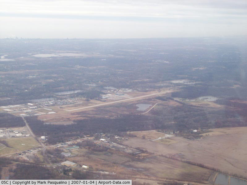
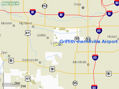
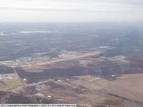
Griffith-Merrillville Airport (FAA LID: 05C) is a public-use airport located two nautical miles (4 km) east of the central business district of Griffith, a town in Lake County, Indiana, United States. It is privately owned by Griffith Aviation, Inc.
Facilities and aircraft
Griffith-Merrillville Airport covers an area of 122 acres (49 ha) at an elevation of 634 feet (193 m) above mean sea level. It has one asphalt paved runway designated 8/26 which measures 4,900 by 75 feet (1,494 x 23 m). The runway has VOR/DME, GPS Instrument Approaches and Pilot Controlled Lighting.
Airport services include a fixed base operator (FBO) and flight school from Griffith Aviation, full service maintenance from Great Northern and custom engine overhauls from G & N Aircraft. Both 100LL gas and Jet A fuel are available.
For the 12-month period ending August 23, 2006, the airport had 33,699 aircraft operations, an average of 92 per day: 99% general aviation and 1% air taxi. At that time there were 61 aircraft based at this airport: 67% single-engine, 23% multi-engine and 10% helicopter.
The above content comes from Wikipedia and is published under free licenses – click here to read more.
|
 |
(Click on the photo to enlarge) |
Location
& QuickFacts
|
FAA
Information Effective: |
2008-06-05 |
|
Airport
Identifier: |
05C |
|
Airport
Status: |
Operational |
|
Longitude/Latitude: |
087-23-58.2287W/41-31-11.4276N
-87.399508/41.519841 (Estimated) |
|
Elevation: |
634 ft / 193.24 m (Surveyed) |
|
Land: |
122 acres |
|
From nearest
city: |
2 nautical miles E of Griffith, IN |
|
Location: |
Lake County, IN |
|
Magnetic
Variation: |
03W (2000) |
Owner
& Manager
|
Ownership: |
Privately
owned |
|
Owner: |
Griffith Aviation Inc |
|
Address: |
1705 E. Main St.
Griffith, IN 46319 |
|
Phone
number: |
219-924-0207 |
|
Manager: |
Craig Anderson |
|
Address: |
1705 E. Main St.
Griffith, IN 46319 |
|
Phone
number: |
219-924-0207 |
Airport
Operations and Facilities
|
Airport
Use: |
Open
to public |
|
Wind indicator: |
Yes |
|
Segmented
Circle: |
No |
|
Control
Tower: |
No |
|
Lighting
Schedule: |
RDO-CTL
ACTVT MIRL RY 08/26, REIL RYS 08 & 26 & PAPI RYS
08 & 26 - CTAF. |
|
Beacon
Color: |
Clear-Green (lighted land airport) |
|
Landing
fee charge: |
No |
|
Sectional
chart: |
Chicago |
|
Region: |
AGL - Great Lakes |
|
Boundary
ARTCC: |
ZAU - Chicago |
|
Tie-in
FSS: |
HUF - Terre Haute |
|
FSS on
Airport: |
No |
|
FSS Toll
Free: |
1-800-WX-BRIEF |
|
NOTAMs
Facility: |
HUF (NOTAM-d service avaliable) |
|
Federal
Agreements: |
N |
Airport
Communications
|
CTAF: |
123.000 |
|
Unicom: |
123.000
|
Airport
Services
|
Fuel
available: |
100LLA |
|
Airframe
Repair: |
MAJOR |
|
Power
Plant Repair: |
MAJOR |
|
Bottled
Oxygen: |
LOW |
|
Bulk Oxygen: |
LOW |
|
Runway Information
Runway 08/26
|
Dimension: |
4900 x 75 ft
/ 1493.5 x 22.9 m |
|
Surface: |
ASPH, Good Condition |
|
Surface Treatment: |
Saw-cut or plastic Grooved |
|
Edge Lights: |
Medium |
|
|
Runway 08 |
Runway 26 |
|
Longitude: |
087-24-29.9500W |
087-23-26.5074W |
|
Latitude: |
41-31-07.2400N |
41-31-15.6151N |
|
Elevation: |
634.00 ft |
632.00 ft |
|
Alignment: |
80 |
127 |
|
Traffic
Pattern: |
Left |
Left |
|
Markings: |
Basic, Good Condition |
Basic, Good Condition |
|
Crossing
Height: |
43.00 ft |
33.00 ft |
|
Displaced
threshold: |
0.00 ft |
1120.00 ft |
|
VASI: |
2-light PAPI on left side |
2-light PAPI on right side |
|
Visual Glide
Angle: |
3.50° |
4.00° |
|
Runway End
Identifier: |
Yes |
Yes |
|
Centerline
Lights: |
No |
No |
|
Touchdown
Lights: |
No |
No |
|
Obstruction: |
15 ft bldg, 425.0 ft from runway, 26 ft left
of centerline, 15:1 slope to clear |
46 ft trees, 360.0 ft from runway, 3:1 slope
to clear
CLNC SLOPE TO DISP THLD 32:1 |
|
Radio Navigation
Aids
|
ID |
Type |
Name |
Ch |
Freq |
Var |
Dist |
|
MX |
NDB |
Kedzi |
|
248.00 |
01W |
18.6 nm |
|
HK |
NDB |
Ermin |
|
332.00 |
01W |
23.0 nm |
|
VP |
NDB |
Sedly |
|
212.00 |
02W |
23.9 nm |
|
IUL |
NDB |
La Porte |
|
356.00 |
03W |
28.3 nm |
|
MGC |
NDB |
Michigan City |
|
203.00 |
01W |
28.5 nm |
|
RZL |
NDB |
Rensselaer |
|
362.00 |
02W |
35.8 nm |
|
ME |
NDB |
Deana |
|
350.00 |
00E |
38.9 nm |
|
RWN |
NDB |
Winamac/dcmsnd |
|
335.00 |
00W |
44.1 nm |
|
CPB |
NDB |
Culver |
|
391.00 |
01W |
49.3 nm |
|
IKK |
VOR/DME |
Kankakee |
053X |
111.60 |
00E |
33.6 nm |
|
OXI |
VOR/DME |
Knox |
103X |
115.60 |
00E |
35.8 nm |
|
ORD |
VOR/DME |
Chicago O'hare |
086X |
113.90 |
02E |
36.1 nm |
|
DPA |
VOR/DME |
Dupage |
021X |
108.40 |
02E |
48.1 nm |
|
OBK |
VOR/DME |
Northbrook |
077X |
113.00 |
02W |
48.9 nm |
|
CGT |
VORTAC |
Chicago Heights |
089X |
114.20 |
02E |
7.8 nm |
|
EON |
VORTAC |
Peotone |
079X |
113.20 |
02E |
23.2 nm |
|
JOT |
VORTAC |
Joliet |
070X |
112.30 |
02E |
41.4 nm |
|
MDW |
VOT |
Chicago Midway |
|
111.00 |
|
22.5 nm |
|
ORD |
VOT |
Chicago O'hare Intl |
|
112.00 |
|
35.9 nm |
Remarks
Based Aircraft
|
Aircraft
based on field: |
64 |
|
Single Engine
Airplanes: |
41 |
|
Multi Engine Airplanes: |
16 |
|
Helicopters: |
7 |
Operational Statistics
Time
Period: 2005-08-24 - 2006-08-23
|
Aircraft
Operations: |
93/Day |
|
Air Taxi: |
1.0% |
|
General Aviation
Local: |
13.0% |
|
General Aviation
Itinerant: |
86.0% |
Griffith-merrillville Airport
Address:
Lake County, IN
Tel:
219-924-0207
Images
and information placed above are from
http://www.airport-data.com/airport/05C/
We
thank them for the data!
| General
Info |
| Country |
United
States |
| State |
INDIANA
|
| FAA ID |
05C |
| Latitude |
41-31-10.629N
|
| Longitude |
087-24-03.936W
|
| Elevation |
634 feet
|
| Near City |
GRIFFITH
|
We don't guarantee the information is fresh and accurate. The data may
be wrong or outdated.
For more up-to-date information please refer to other sources.
|
|