 |
|
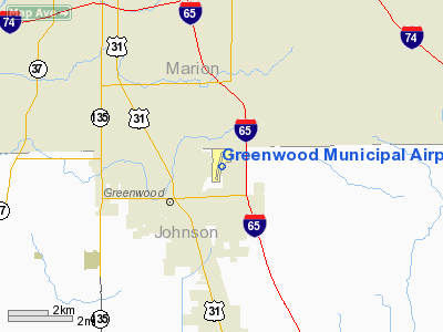
Greenwood Municipal Airport |
|
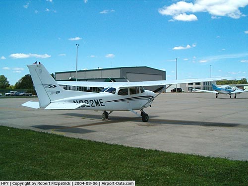 |
(Click on the photo to enlarge) |
|
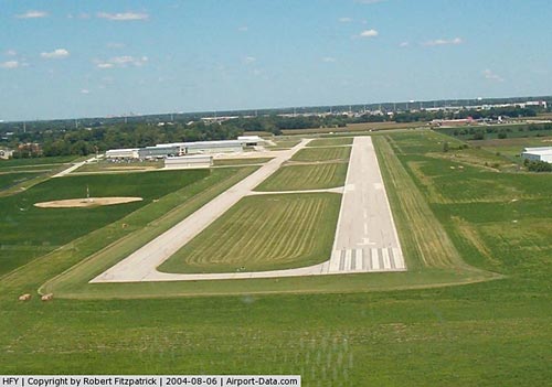 |
(Click on the photo to enlarge) |
Location
& QuickFacts
|
FAA
Information Effective: |
2008-06-05 |
|
Airport
Identifier: |
HFY |
|
Airport
Status: |
Operational |
|
Longitude/Latitude: |
086-05-16.9000W/39-37-39.4000N
-86.088028/39.627611 (Estimated) |
|
Elevation: |
822 ft / 250.55 m (Surveyed) |
|
Land: |
148 acres |
|
From nearest
city: |
10 nautical miles SE of Indianapolis, IN |
|
Location: |
Johnson County, IN |
|
Magnetic
Variation: |
02W (1990) |
Owner
& Manager
|
Ownership: |
Publicly
owned |
|
Owner: |
Greenwood Boac |
|
Address: |
2 N Madison Ave
Greenwood, IN 46142 |
|
Phone
number: |
317-881-8527 |
|
Manager: |
Darin Schroeder |
|
Address: |
799 E. Co. Line Rd
Greenwood, IN 46143 |
|
Phone
number: |
317-881-0887 |
Airport
Operations and Facilities
|
Airport
Use: |
Open
to public |
|
Wind indicator: |
Yes |
|
Segmented
Circle: |
No |
|
Control
Tower: |
No |
|
Lighting
Schedule: |
SS-SR
HIRL RY 01/19 PRESET LOW INTST; TO INCR INTST ACTVT REIL
RYS 01 & 19 - CTAF. |
|
Beacon
Color: |
Clear-Green (lighted land airport) |
|
Landing
fee charge: |
No |
|
Sectional
chart: |
St Louis |
|
Region: |
AGL - Great Lakes |
|
Traffic
Pattern Alt: |
800 ft |
|
Boundary
ARTCC: |
ZID - Indianapolis |
|
Tie-in
FSS: |
HUF - Terre Haute |
|
FSS on
Airport: |
No |
|
FSS Toll
Free: |
1-800-WX-BRIEF |
|
NOTAMs
Facility: |
HUF (NOTAM-d service avaliable) |
|
Federal
Agreements: |
NGY |
Airport
Communications
|
CTAF: |
123.000 |
|
Unicom: |
123.000
|
Airport
Services
|
Fuel
available: |
100LLA |
|
Airframe
Repair: |
MAJOR |
|
Power
Plant Repair: |
MAJOR |
|
Bottled
Oxygen: |
HIGH/LOW |
|
Bulk Oxygen: |
HIGH/LOW |
|
Runway Information
Runway 01/19
|
Dimension: |
4901 x 75 ft
/ 1493.8 x 22.9 m |
|
Surface: |
ASPH, Good Condition |
|
Edge Lights: |
High |
|
|
Runway 01 |
Runway 19 |
|
Longitude: |
086-05-21.0653W |
086-05-12.7315W |
|
Latitude: |
39-37-15.4003N |
39-38-03.4020N |
|
Elevation: |
821.00 ft |
820.00 ft |
|
Alignment: |
8 |
127 |
|
Traffic
Pattern: |
Left |
Left |
|
Markings: |
Non-precision instrument, Good Condition |
Non-precision instrument, Good Condition |
|
Crossing
Height: |
39.00 ft |
40.00 ft |
|
VASI: |
4-light PAPI on left side |
4-light PAPI on left side |
|
Visual Glide
Angle: |
3.00° |
3.00° |
|
Runway End
Identifier: |
Yes |
Yes |
|
Obstruction: |
59 ft tree, 1333.0 ft from runway, 500 ft right
of centerline, 19:1 slope to clear |
18 ft road, 818.0 ft from runway, 280 ft right
of centerline, 34:1 slope to clear |
|
Radio Navigation
Aids
|
ID |
Type |
Name |
Ch |
Freq |
Var |
Dist |
|
HFY |
NDB |
Greenwood |
|
398.00 |
02W |
0.4 nm |
|
UMP |
NDB |
Metropolitan |
|
338.00 |
03W |
18.7 nm |
|
HZP |
NDB |
Zionsville |
|
248.00 |
03W |
20.2 nm |
|
BA |
NDB |
Clifs |
|
410.00 |
03W |
22.2 nm |
|
TVX |
NDB |
Greencastle |
|
521.00 |
03W |
33.6 nm |
|
AI |
NDB |
Video |
|
371.00 |
03W |
37.6 nm |
|
UWL |
NDB |
New Castle |
|
385.00 |
02W |
38.6 nm |
|
OVO |
NDB |
North Vernon |
|
374.00 |
02W |
41.5 nm |
|
BM |
NDB |
Claye |
|
382.00 |
02W |
41.8 nm |
|
HLB |
NDB |
Batesville |
|
254.00 |
02W |
42.0 nm |
|
CFJ |
NDB |
Crawfordsville |
|
388.00 |
02W |
43.7 nm |
|
FKR |
NDB |
Frankfort |
|
278.00 |
02W |
44.4 nm |
|
EQZ |
NDB |
Captain |
|
308.00 |
02W |
46.0 nm |
|
MIE |
VOR/DME |
Muncie |
091X |
114.40 |
03W |
48.6 nm |
|
SHB |
VORTAC |
Shelbyville |
057X |
112.00 |
01E |
12.2 nm |
|
VHP |
VORTAC |
Brickyard |
110X |
116.30 |
01E |
17.1 nm |
|
OOM |
VORTAC |
Hoosier |
039X |
110.20 |
02W |
38.0 nm |
|
IND |
VOT |
Indianapolis Intl |
|
109.60 |
|
10.7 nm |
Remarks
- RY
01/19 10 FT DRAINAGE DITCH 125 FT R & L OF CNTRLN.
- HIGH
INTENSITY STUDENT TRAINING.
Based Aircraft
|
Aircraft
based on field: |
137 |
|
Single Engine
Airplanes: |
127 |
|
Multi Engine Airplanes: |
10 |
Operational Statistics
Time
Period: 2005-06-30 - 2006-06-29
|
Aircraft
Operations: |
104/Day |
|
Air Taxi: |
3.0% |
|
General Aviation
Local: |
43.9% |
|
General Aviation
Itinerant: |
50.1% |
|
Military: |
3.0% |
Greenwood Municipal Airport
Address:
Johnson County, IN
Tel:
317-881-8527,
317-881-0887
Images
and information placed above are from
http://www.airport-data.com/airport/HFY/
We
thank them for the data!
| General
Info |
| Country |
United
States |
| State |
INDIANA
|
| FAA ID |
HFY |
| Latitude |
39-37-42.300N
|
| Longitude |
086-05-16.400W
|
| Elevation |
822 feet
|
| Near City |
INDIANAPOLIS
|
We don't guarantee the information is fresh and accurate. The data may
be wrong or outdated.
For more up-to-date information please refer to other sources.
|
|


