 |
|
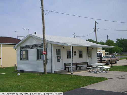
Greensburg-decatur County Airport |
Greensburg-Decatur County Airport
Greensburg Municipal Airport |
| IATA: none â ICAO: none â FAA LID: I34 |
| Summary |
| Airport type |
Public |
| Owner |
Greensburg-Decatur County
Board of Aviation
Commissioners |
| Serves |
Greensburg, Indiana |
| Elevation AMSL |
912 ft / 278 m |
| Coordinates |
39°19â²37â³N 085°31â²21â³W / 39.32694°N 85.5225°W / 39.32694; -85.5225 |
| Runways |
| Direction |
Length |
Surface |
| ft |
m |
| 18/36 |
3,433 |
1,046 |
Asphalt |
| Statistics (2008) |
| Aircraft operations |
9,775 |
| Based aircraft |
37 |
| Source: Federal Aviation Administration |
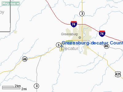
Greensburg-Decatur County Airport (FAA LID: I34) is a public use airport located two nautical miles (4 km) southwest of the central business district of Greensburg, a city in Decatur County, Indiana, United States. The airport is owned by the Greensburg-Decatur County Board of Aviation Commissioners. It is also known as Greensburg Municipal Airport.
Facilities and aircraft
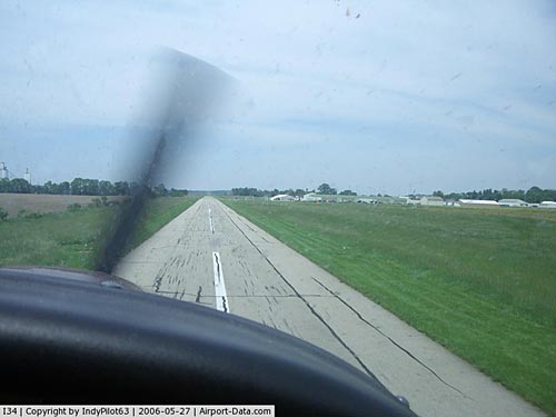
Greensburg-Decatur County Airport covers an area of 30 acres (12 ha) at an elevation of 912 feet (278 m) above mean sea level. It has one asphalt paved runway designated 18/36 which measures 3,433 by 40 feet (1,046 x 12 m).
For the 12-month period ending December 31, 2008, the airport had 9,775 aircraft operations, an average of 26 per day: 99% general aviation and 1% air taxi, At that time there were 37 aircraft based at this airport, all single-engine.
The above content comes from Wikipedia and is published under free licenses – click here to read more.
|
 |
(Click on the photo to enlarge) |
|
 |
(Click on the photo to enlarge) |
Location
& QuickFacts
|
FAA
Information Effective: |
2008-06-05 |
|
Airport
Identifier: |
I34 |
|
Airport
Status: |
Operational |
|
Longitude/Latitude: |
085-31-21.0970W/39-19-36.8800N
-85.522527/39.326911 (Estimated) |
|
Elevation: |
912 ft / 277.98 m (Surveyed) |
|
Land: |
30 acres |
|
From nearest
city: |
2 nautical miles SW of Greensburg, IN |
|
Location: |
Decatur County, IN |
|
Magnetic
Variation: |
04W (2005) |
Owner
& Manager
|
Ownership: |
Publicly
owned |
|
Owner: |
Greensburg-decatur Co Boac |
|
Address: |
915 200 W
Greensburg, IN 47240 |
|
Phone
number: |
812-663-5733 |
|
Manager: |
Tom Schoettmer |
|
Address: |
1434 E Base Road
Greensburg,
IN 47240 |
|
Phone
number: |
812-663-5733 |
Airport Operations
and Facilities
|
Airport
Use: |
Open
to public |
|
Wind indicator: |
Yes |
|
Segmented
Circle: |
No |
|
Control
Tower: |
No |
|
Lighting
Schedule: |
DUSK-DAWN
ACTVT MIRL RY 18/36 & VASI RWYS 18 & 36 - CTAF. |
|
Beacon
Color: |
Clear-Green (lighted land airport) |
|
Landing
fee charge: |
No |
|
Sectional
chart: |
St Louis |
|
Region: |
AGL - Great Lakes |
|
Boundary
ARTCC: |
ZID - Indianapolis |
|
Tie-in
FSS: |
HUF - Terre Haute |
|
FSS on
Airport: |
No |
|
FSS Toll
Free: |
1-800-WX-BRIEF |
|
NOTAMs
Facility: |
HUF (NOTAM-d service avaliable) |
|
Federal
Agreements: |
N |
Airport Communications
Airport
Services
|
Fuel
available: |
100LLA |
|
Airframe
Repair: |
MINOR |
|
Power
Plant Repair: |
MINOR |
|
Runway Information
Runway 18/36
|
Dimension: |
3433 x 40 ft
/ 1046.4 x 12.2 m |
|
Surface: |
ASPH, Good Condition |
|
Edge Lights: |
Medium |
|
|
Runway 18 |
Runway 36 |
|
Longitude: |
085-31-21.3290W |
085-31-20.9490W |
|
Latitude: |
39-19-53.8470N |
39-19-19.9160N |
|
Elevation: |
912.00 ft |
905.00 ft |
|
Alignment: |
127 |
127 |
|
Traffic
Pattern: |
Left |
Left |
|
Markings: |
Basic, Fair Condition |
Basic, Fair Condition |
|
Crossing
Height: |
19.00 ft |
0.00 ft |
|
Displaced
threshold: |
500.00 ft |
100.00 ft |
|
VASI: |
2-box on left side |
2-box on left side |
|
Visual Glide
Angle: |
2.80° |
2.80° |
|
Runway End
Identifier: |
No |
No |
|
Centerline
Lights: |
No |
No |
|
Touchdown
Lights: |
No |
No |
|
Obstruction: |
20 ft road, 250.0 ft from runway, 2:1 slope
to clear
RY 18 APCH RATIO TO DISP THLD 32:1.
RY
18 SCATTERED BRUSH & +4 FT FENCE 100 FT FM RY END. |
10 ft crops, 201.0 ft from runway
RY 36 APCH RATIO 18:1 DUE TO 10 FT SEASONAL CROPS 185 FT FM
DSPLCD THLD.
RY
36 10 FT CROPS 85 FT FM RY END. |
|
Radio Navigation
Aids
|
ID |
Type |
Name |
Ch |
Freq |
Var |
Dist |
|
HLB |
NDB |
Batesville |
|
254.00 |
02W |
12.4 nm |
|
BA |
NDB |
Clifs |
|
410.00 |
03W |
13.8 nm |
|
OVO |
NDB |
North Vernon |
|
374.00 |
02W |
17.1 nm |
|
HFY |
NDB |
Greenwood |
|
398.00 |
02W |
32.1 nm |
|
IMS |
NDB |
Madison |
|
404.00 |
03W |
34.1 nm |
|
UWL |
NDB |
New Castle |
|
385.00 |
02W |
34.6 nm |
|
EQZ |
NDB |
Captain |
|
308.00 |
02W |
34.7 nm |
|
OXD |
NDB |
Oxford |
|
282.00 |
04W |
36.1 nm |
|
UR |
NDB |
Burln |
|
321.00 |
04W |
38.8 nm |
|
UMP |
NDB |
Metropolitan |
|
338.00 |
03W |
44.1 nm |
|
HAO |
NDB |
Hamilton |
|
260.00 |
04W |
44.3 nm |
|
AI |
NDB |
Video |
|
371.00 |
03W |
44.6 nm |
|
HZP |
NDB |
Zionsville |
|
248.00 |
03W |
49.9 nm |
|
SHB |
VORTAC |
Shelbyville |
057X |
112.00 |
01E |
23.1 nm |
|
RID |
VORTAC |
Richmond |
043X |
110.60 |
03W |
40.8 nm |
|
CVG |
VORTAC |
Cincinnati |
120X |
117.30 |
04W |
42.5 nm |
|
ABB |
VORTAC |
Nabb |
071X |
112.40 |
01E |
44.7 nm |
|
VHP |
VORTAC |
Brickyard |
110X |
116.30 |
01E |
48.9 nm |
|
IND |
VOT |
Indianapolis Intl |
|
109.60 |
|
42.6 nm |
Remarks
- RY
36 SEASONAL CROPS 180' FM THR 0B 4'- 10'HIGH.
- EXISTED
PRIOR TO 1959.
Based Aircraft
|
Aircraft
based on field: |
41 |
|
Single Engine
Airplanes: |
39 |
|
Multi Engine Airplanes: |
1 |
|
Helicopters: |
1 |
Operational Statistics
Time
Period: 2005-09-22 - 2006-09-21
|
Aircraft
Operations: |
55/Day |
|
Air Taxi: |
1.0% |
|
General Aviation
Local: |
81.0% |
|
General Aviation
Itinerant: |
18.0% |
Greensburg-decatur County Airport
Address:
Decatur County, IN
Tel:
812-663-5733
Images
and information placed above are from
http://www.airport-data.com/airport/I34/
We
thank them for the data!
| General
Info |
| Country |
United
States |
| State |
INDIANA
|
| FAA ID |
I34 |
| Latitude |
39-19-36.880N
|
| Longitude |
085-31-21.097W
|
| Elevation |
912 feet
|
| Near City |
GREENSBURG
|
We don't guarantee the information is fresh and accurate. The data may
be wrong or outdated.
For more up-to-date information please refer to other sources.
|
|


