|
|
|
 |
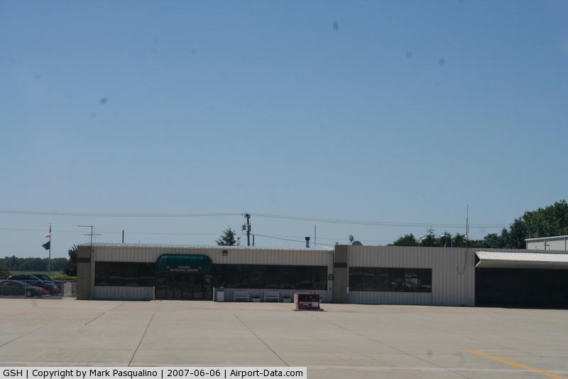
(Click on the photo to enlarge) |
|
 |
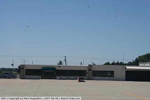
(Click on the photo to enlarge) |
Location
& QuickFacts
|
FAA
Information Effective: |
2008-06-05 |
|
Airport
Identifier: |
GSH |
|
Airport
Status: |
Operational |
|
Longitude/Latitude: |
085-47-34.3650W/41-31-35.0580N
-85.792879/41.526405 (Estimated) |
|
Elevation: |
827 ft / 252.07 m (Surveyed) |
|
Land: |
439 acres |
|
From nearest
city: |
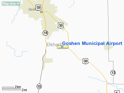
3 nautical miles SE of Goshen, IN |
|
Location: |
Elkhart County, IN |
|
Magnetic
Variation: |
04W (2000) |
Owner
& Manager
|
Ownership: |
Publicly
owned |
|
Owner: |
Goshen Boac |
|
Address: |
111 E Jefferson
Goshen, IN 46526 |
|
Phone
number: |
574-537-9555 |
|
Manager: |
Randy Sharkey |
|
Address: |
17229 Cr 42
Goshen, IN 46526 |
|
Phone
number: |
574-533-8245
OR 574-642-3123. ALSO, A 24-HR PHONE AVBL. |
Airport
Operations and Facilities
|
Airport
Use: |
Open
to public |
|
Wind indicator: |
Yes |
|
Segmented
Circle: |
No |
|
Control
Tower: |
No |
|
Lighting
Schedule: |
DUSK-DAWN
HIRL RY 09/27 PRESET LOW INTST; TO INCR INTST & ACTVT
REIL RYS 09 & 27 - CTAF. |
|
Beacon
Color: |
Clear-Green (lighted land airport) |
|
Landing
fee charge: |
No |
|
Sectional
chart: |
Chicago |
|
Region: |
AGL - Great Lakes |
|
Boundary
ARTCC: |
ZAU - Chicago |
|
Tie-in
FSS: |
HUF - Terre Haute |
|
FSS on
Airport: |
No |
|
FSS Toll
Free: |
1-800-WX-BRIEF |
|
NOTAMs
Facility: |
GSH (NOTAM-d service avaliable) |
|
Federal
Agreements: |
NGY |
Airport Communications
|
CTAF: |
123.050 |
|
Unicom: |
123.050
|
Airport
Services
|
Fuel
available: |
100LLA |
|
Airframe
Repair: |
MAJOR |
|
Power
Plant Repair: |
MAJOR |
|
Bottled
Oxygen: |
HIGH |
|
Runway Information
Runway 05/23
|
Dimension: |
2585 x 180 ft
/ 787.9 x 54.9 m |
|
Surface: |
TURF, Good Condition |
|
|
Runway 05 |
Runway 23 |
|
Longitude: |
085-47-48.3745W |
085-47-24.6363W |
|
Latitude: |
41-31-33.3167N |
41-31-51.5939N |
|
Elevation: |
814.00 ft |
823.00 ft |
|
Alignment: |
44 |
127 |
|
Traffic
Pattern: |
Left |
Left |
|
Runway End
Identifier: |
No |
No |
|
Centerline
Lights: |
No |
No |
|
Touchdown
Lights: |
No |
No |
|
Obstruction: |
35 ft pline, 1400.0 ft from runway, 40:1 slope
to clear |
82 ft pline, 3700.0 ft from runway, 45:1 slope
to clear |
|
Runway 09/27
|
Dimension: |
5000 x 75 ft
/ 1524.0 x 22.9 m |
|
Surface: |
ASPH, Good Condition |
|
Surface Treatment: |
Saw-cut or plastic Grooved |
|
Weight Limit: |
Single wheel: 45000 lbs.
Dual wheel: 60000 lbs.
Dual tandem wheel: 100000 lbs. |
|
Edge Lights: |
High |
|
|
Runway 09 |
Runway 27 |
|
Longitude: |
085-48-06.1221W |
085-47-00.3944W |
|
Latitude: |
41-31-30.9299N |
41-31-31.5400N |
|
Elevation: |
819.00 ft |
827.00 ft |
|
Alignment: |
89 |
127 |
|
ILS Type: |
|
ILS |
|
Traffic
Pattern: |
Left |
Left |
|
Markings: |
Non-precision instrument, Fair Condition |
Precision instrument, Fair Condition |
|
Crossing
Height: |
24.00 ft |
51.00 ft |
|
VASI: |
2-light PAPI on left side |
4-light PAPI on left side |
|
Visual Glide
Angle: |
3.00° |
3.00° |
|
Runway End
Identifier: |
Yes |
Yes |
|
Centerline
Lights: |
No |
No |
|
Touchdown
Lights: |
No |
No |
|
Obstruction: |
111 ft trees, 3102.0 ft from runway, 26:1 slope
to clear |
25 ft bldg, 1180.0 ft from runway, 80 ft left
of centerline, 39:1 slope to clear |
|
Radio Navigation
Aids
|
ID |
Type |
Name |
Ch |
Freq |
Var |
Dist |
|
IRS |
NDB |
Sturgis |
|
382.00 |
04W |
23.6 nm |
|
HAI |
NDB |
Three Rivers |
|
407.00 |
02W |
27.5 nm |
|
ANQ |
NDB |
Angola |
|
347.00 |
05W |
32.5 nm |
|
CPB |
NDB |
Culver |
|
391.00 |
01W |
32.5 nm |
|
RCR |
NDB |
Rochester |
|
216.00 |
03W |
33.0 nm |
|
HHG |
NDB |
Huntington |
|
417.00 |
03W |
43.0 nm |
|
IUL |
NDB |
La Porte |
|
356.00 |
03W |
44.1 nm |
|
RWN |
NDB |
Winamac/dcmsnd |
|
335.00 |
00W |
44.9 nm |
|
IWH |
NDB |
Wabash |
|
329.00 |
03W |
45.8 nm |
|
MGC |
NDB |
Michigan City |
|
203.00 |
01W |
47.3 nm |
|
VP |
NDB |
Sedly |
|
212.00 |
02W |
49.0 nm |
|
OLK |
VOR |
Wolf Lake |
|
110.40 |
03W |
21.4 nm |
|
ELX |
VOR/DME |
Keeler |
113X |
116.60 |
00E |
40.0 nm |
|
OXI |
VOR/DME |
Knox |
103X |
115.60 |
00E |
40.5 nm |
|
AZO |
VOR/DME |
Kalamazoo |
027X |
109.00 |
01W |
44.0 nm |
|
GSH |
VORTAC |
Goshen |
084X |
113.70 |
00E |
10.6 nm |
|
GIJ |
VORTAC |
Gipper |
101X |
115.40 |
00E |
27.7 nm |
|
FWA |
VORTAC |
Fort Wayne |
125X |
117.80 |
00E |
42.8 nm |
|
FWA |
VOT |
Fort Wayne Baer |
|
111.00 |
|
42.7 nm |
Based Aircraft
|
Aircraft
based on field: |
59 |
|
Single Engine
Airplanes: |
39 |
|
Multi Engine Airplanes: |
8 |
|
Jet Engine Airplanes: |
6 |
|
Helicopters: |
3 |
|
Ultralights: |
3 |
Operational Statistics
Time
Period: 2007-01-01 - 2007-12-31
|
Aircraft
Operations: |
85/Day |
|
Air Taxi: |
3.0% |
|
General Aviation
Local: |
74.0% |
|
General Aviation
Itinerant: |
23.0% |
Goshen Municipal Airport
Address:
Elkhart County, IN
Tel:
574-537-9555,
574-533-8245,
574-642-3123
Images
and information placed above are from
http://www.airport-data.com/airport/GSH/
We
thank them for the data!
| General
Info |
| Country |
United
States |
| State |
INDIANA
|
| FAA ID |
GSH |
| Latitude |
41-31-37.800N
|
| Longitude |
085-47-32.300W
|
| Elevation |
827 feet
|
| Near City |
GOSHEN
|
We don't guarantee the information is fresh and accurate. The data may
be wrong or outdated.
For more up-to-date information please refer to other sources.
|
|