 |
|
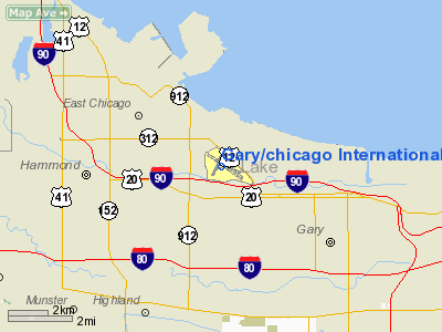
Gary/chicago International Airport |
| Gary/Chicago International Airport |
 |
| IATA: GYY â ICAO: KGYY â FAA LID: GYY |
| Summary |
| Airport type |
Public |
| Owner |
Gary/Chicago Airport Authority |
| Location |
Gary, Indiana |
| Elevation AMSL |
591 ft / 180 m |
| Coordinates |
41°36â²59â³N 087°24â²46â³W / 41.61639°N 87.41278°W / 41.61639; -87.41278 |
| Website |
http://www.garychicagoairport.com/ |
| Runways |
| Direction |
Length |
Surface |
| ft |
m |
| 2/20 |
3,603 |
1,098 |
Asphalt |
| 12/30 |
7,003 |
2,135 |
Grooved Asphalt |
| Source: Federal Aviation Administration |
Gary/Chicago International Airport (IATA: GYY, ICAO: KGYY, FAA LID: GYY) is a public airport located three miles (5 km) northwest of the central business district of Gary, a city in Lake County, Indiana, United States. The airport, which serves the Chicago metropolitan area, is 25 miles (40 km) southeast of the Chicago Loop. It is operated by the Gary Chicago Airport Authority, the basis for which was formed by the Chicago Gary Airport Compact signed in 1995. Gary/Chicago International Airport was a hub for seasonal carrier SkyValue Airlines from December 2006 to April 2007. Nearby highway connections include I-90, I-80, I-94, I-65 and the Chicago Skyway.
A long-standing proposal to turn the Gary/Chicago International Airport into Chicago's third major airport received a boost in early 2006 with the approval of $48 million in federal funding over the next ten years.
Expansion plans include a new multi-level Intermodal Terminal combining three modes of transit â passenger rail, passenger vehicles, and air travel. The rail system is designed to combine both commuter and high-speed lines. History
Gary/Chicago is operating as the "third airport" for the Chicago metropolitan area, supplementing Chicago's major airports, O'Hare and Midway. Gary/Chicago Airport has been designed with an eye towards growth, and the administration is courting the airlines aggressively. Numerous businesses, including Boeing, Menards and White Lodging Services, base their corporate aircraft here. A National Guard installation has also been constructed.
Federal funds were secured in January 2006 to move railroad tracks away from the northwest corner to allow extension of the main runway to 9,000 feet, as well as add gates to the existing passenger terminal building. The recent creation of the Northwest Indiana Regional Development Authority is expected to draw more state and local dollars for infrastructure improvements and additions.
Expanding Gary/Chicago Airport is considered an alternative to constructing a new airport near Peotone, Illinois, 30 miles south of Chicago. One advantage of expanding the Gary airport is its proximity to downtown Chicago. This plan is backed by the mayors of Gary and Chicago, while the Illinois state government is in favor of construction at Peotone. Tax revenues from a new airport at Peotone would go to the Illinois state government, while those from an expanded Gary airport would go to a regional airport authority, and thus to the cities of Chicago and Gary.
Service
In the past, Gary/Chicago International Airport has been served by Pan Am, Southeast Airlines, SkyValue Airlines, Skybus Airlines and Hooters Air, with flights to locations such as Hartford, Connecticut; St. Petersburg, Florida; Greensboro, North Carolina and Myrtle Beach, South Carolina. Prior to its bankruptcy problems in 2004, ATA Airlines had planned turboprop service to several Indiana cities. This service was to be operated by its subsidiary, Chicago Express/ATA Connection, but the proposed service was never started as Chicago Express Airlines was grounded in March 2005. Before ultimately choosing to serve Chicago O'Hare International Airport in 2006, JetBlue Airways considered adding service to Gary/Chicago International Airport. However, the airline reports it may add Gary/Chicago Airport to its route system in the future.
Skybus Airlines served the airport until the airline folded on April 4, 2008. Since that, there have been no scheduled flights out of the Gary/Chicago Airport.
Activity
- Chicago-based Boeing selected the airport to permanently base its Midwest corporate jet fleet.
- For many years airplanes seen in the Chicago Air & Water Show have flown from here, including the military's C5A Galaxy and the Thunderbirds. Since 1999, the Gary Air Show has based their operations here as well.
- High tension power lines along the West end of the airport are buried. A tentative agreement has been reached with the railroads that will allow relocation of elevated tracks currently blocking the west end of runway 30. Completion of these projects is required to make way for a lengthening of the main runway.
Ground transportation
The South Shore Line commuter rail train serves the Gary/Chicago International Airport. The station, which is known as Gary Airport/Clark Road, is located near Second Avenue, approximately one mile south of the terminal.
The above content comes from Wikipedia and is published under free licenses – click here to read more.
|
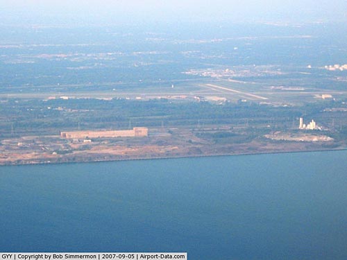 |
(Click on the photo to enlarge) |
Location
& QuickFacts
|
FAA
Information Effective: |
2007-12-20 |
|
Airport
Identifier: |
GYY |
|
Airport
Status: |
Operational |
|
Longitude/Latitude: |
087-24-46.0000W/41-36-58.6000N
-87.412778/41.616278 (Estimated) |
|
Elevation: |
591 ft / 180.14 m (Surveyed) |
|
Land: |
675 acres |
|
From nearest
city: |
3 nautical miles NW of Gary, IN |
|
Location: |
Lake County, IN |
|
Magnetic
Variation: |
02W (1990) |
Owner
& Manager
|
Ownership: |
Publicly
owned |
|
Owner: |
Gary/chicago Arpt Auth Dist |
|
Address: |
6001 Industrial Hwy
Gary,
IN 46406 |
|
Phone
number: |
219-949-9722 |
|
Manager: |
Chris Curry |
|
Address: |
6001 Industrial Hwy
Gary,
IN 46406 |
|
Phone
number: |
219-949-9722 |
Airport
Operations and Facilities
|
Airport
Use: |
Open
to public |
|
Wind indicator: |
Yes |
|
Segmented
Circle: |
Yes |
|
Control
Tower: |
Yes |
|
Lighting
Schedule: |
DUSK-DAWN
WHEN ATCT CLSD ACTVT HIRL RY 12/30; MIRL RY 02/20, REIL
RYS 02, 12 & 20 & MALSR RY 30 - CTAF. |
|
Beacon
Color: |
Clear-Green (lighted land airport) |
|
Landing
fee charge: |
Yes
LNDG FEE FOR ACFT 12500 LBS & OVER & ALL TWIN ENGINE
ACFT. |
|
Sectional
chart: |
Chicago |
|
Region: |
AGL - Great Lakes |
|
Boundary
ARTCC: |
ZAU - Chicago |
|
Tie-in
FSS: |
HUF - Terre Haute |
|
FSS on
Airport: |
No |
|
FSS Toll
Free: |
1-800-WX-BRIEF |
|
NOTAMs
Facility: |
GYY (NOTAM-d service avaliable) |
|
Certification
type/date: |
I B U 08/1981
ARFF INDEX C AVBL 4 HOURS PPR CONTACT 219-949-4922. |
|
Federal
Agreements: |
NGSY |
Airport Communications
Airport
Services
|
Fuel
available: |
100LLA |
|
Airframe
Repair: |
MAJOR |
|
Power
Plant Repair: |
MAJOR |
|
Bottled
Oxygen: |
NONE |
|
Runway Information
Runway 02/20
|
Dimension: |
3603 x 100 ft
/ 1098.2 x 30.5 m |
|
Surface: |
ASPH, Good Condition |
|
Weight Limit: |
Single wheel: 18000 lbs.
Dual wheel: 28000 lbs. |
|
Edge Lights: |
Medium |
|
|
Runway 02 |
Runway 20 |
|
Longitude: |
087-25-06.2969W |
087-24-49.1519W |
|
Latitude: |
41-36-44.2157N |
41-37-17.4144N |
|
Elevation: |
589.00 ft |
589.00 ft |
|
Alignment: |
21 |
127 |
|
Traffic
Pattern: |
Left |
Left |
|
Markings: |
Basic, Fair Condition |
Basic, Fair Condition |
|
Crossing
Height: |
35.00 ft |
39.00 ft |
|
VASI: |
2-light PAPI on left side |
2-light PAPI on left side |
|
Visual Glide
Angle: |
3.00° |
3.00° |
|
Runway End
Identifier: |
Yes |
Yes |
|
Centerline
Lights: |
No |
No |
|
Touchdown
Lights: |
No |
No |
|
Obstruction: |
42 ft road, 1050.0 ft from runway, 20:1 slope
to clear |
19 ft road, 580.0 ft from runway, 20:1 slope
to clear |
|
Runway 12/30
|
Dimension: |
7003 x 150 ft
/ 2134.5 x 45.7 m |
|
Surface: |
ASPH, Good Condition |
|
Weight Limit: |
Single wheel: 75000 lbs.
Dual wheel: 157000 lbs.
Dual tandem wheel: 250000 lbs. |
|
Edge Lights: |
High |
|
|
Runway 12 |
Runway 30 |
|
Longitude: |
087-25-18.1350W |
087-24-01.8477W |
|
Latitude: |
41-37-16.8441N |
41-36-37.9973N |
|
Elevation: |
590.00 ft |
591.00 ft |
|
Alignment: |
124 |
127 |
|
ILS Type: |
|
ILS/DME |
|
Traffic
Pattern: |
Left |
Left |
|
Markings: |
Non-precision instrument, Good Condition |
Precision instrument, Good Condition |
|
Crossing
Height: |
50.00 ft |
50.00 ft |
|
Displaced
threshold: |
713.00 ft |
0.00 ft |
|
VASI: |
4-light PAPI on left side |
4-light PAPI on left side |
|
Visual Glide
Angle: |
3.00° |
3.00° |
|
Approach
lights: |
|
MALSR |
|
Runway End
Identifier: |
Yes |
No |
|
Centerline
Lights: |
Yes |
Yes |
|
Touchdown
Lights: |
No |
No |
|
Obstruction: |
37 ft pole, 188.0 ft from runway, 90 ft left
of centerline, 20:1 slope to clear
APCH RATIO 18:1 AT DSPLCD THR.
37 FT LGTD POLES 188 FT FM RY END, 90 FT L OF CNTRLN; TREES,
SHRUBS AND RR ENBANKMENT. |
68 ft pole, 2522.0 ft from runway, 220 ft left
of centerline, 34:1 slope to clear |
|
Radio Navigation
Aids
|
ID |
Type |
Name |
Ch |
Freq |
Var |
Dist |
|
MX |
NDB |
Kedzi |
|
248.00 |
01W |
14.5 nm |
|
HK |
NDB |
Ermin |
|
332.00 |
01W |
20.0 nm |
|
VP |
NDB |
Sedly |
|
212.00 |
02W |
26.0 nm |
|
MGC |
NDB |
Michigan City |
|
203.00 |
01W |
27.3 nm |
|
IUL |
NDB |
La Porte |
|
356.00 |
03W |
29.7 nm |
|
ME |
NDB |
Deana |
|
350.00 |
00E |
34.7 nm |
|
RZL |
NDB |
Rensselaer |
|
362.00 |
02W |
41.5 nm |
|
RWN |
NDB |
Winamac/dcmsnd |
|
335.00 |
00W |
48.1 nm |
|
ORD |
VOR/DME |
Chicago O'hare |
086X |
113.90 |
02E |
31.4 nm |
|
IKK |
VOR/DME |
Kankakee |
053X |
111.60 |
00E |
38.1 nm |
|
OXI |
VOR/DME |
Knox |
103X |
115.60 |
00E |
38.7 nm |
|
OBK |
VOR/DME |
Northbrook |
077X |
113.00 |
02W |
43.6 nm |
|
DPA |
VOR/DME |
Dupage |
021X |
108.40 |
02E |
45.1 nm |
|
CGT |
VORTAC |
Chicago Heights |
089X |
114.20 |
02E |
9.6 nm |
|
EON |
VORTAC |
Peotone |
079X |
113.20 |
02E |
26.9 nm |
|
JOT |
VORTAC |
Joliet |
070X |
112.30 |
02E |
40.9 nm |
|
GIJ |
VORTAC |
Gipper |
101X |
115.40 |
00E |
50.0 nm |
|
MDW |
VOT |
Chicago Midway |
|
111.00 |
|
18.3 nm |
|
ORD |
VOT |
Chicago O'hare Intl |
|
112.00 |
|
31.2 nm |
Remarks
- BIRDS;
COYOTES & DEER & OTHER WILDLIFE AND MIGRATORY WATERFOWL.
ON & INVOF ARPT.
- UNCONTROLLED
VEHICLES ON RAMPS NORTH SIDE OF ARPT.
- RY
2/20 AVBL TO ACR ACFT MORE THAN 9 SEATS FOR TAXIING ONLY BTN RY 12/30
AND TWY A. TWYS A, A-1, A-2, A-4 AND TWY C NORTH OF RY 12/30 AVAIL TO
AIR CARRIER ACFT WITH MORE THAN 9 SEATS.
Based Aircraft
|
Aircraft
based on field: |
96 |
|
Single Engine
Airplanes: |
49 |
|
Multi Engine Airplanes: |
16 |
|
Jet Engine Airplanes: |
18 |
|
Helicopters: |
13 |
Operational Statistics
Time
Period: 2005-01-01 - 2005-12-31
|
Aircraft
Operations: |
124/Day |
|
Commerical: |
1.7% |
|
Air Taxi: |
3.5% |
|
General Aviation
Local: |
48.1% |
|
General Aviation
Itinerant: |
45.5% |
|
Military: |
1.3% |
Gary/chicago International Airport
Address:
Lake County, IN
Tel:
219-949-9722
Images
and information placed above are from
http://www.airport-data.com/airport/GYY/
We
thank them for the data!
| General
Info |
| Country |
United
States |
| State |
INDIANA
|
| FAA ID |
GYY |
| Latitude |
41-36-58.583N
|
| Longitude |
087-24-46.037W
|
| Elevation |
592 feet
|
| Near City |
GARY |
We don't guarantee the information is fresh and accurate. The data may
be wrong or outdated.
For more up-to-date information please refer to other sources.
|
|


