 |
|
| Gardner Airport |
| IATA: none – ICAO: none – FAA LID: 88IN |
| Summary |
| Airport type |
Private |
| Owner/Operator |
George D. Gardner |
| Location |
Boggstown, Indiana |
| Elevation AMSL |
740 ft / 226 m |
| Coordinates |
39°44′47″N 085°55′56″W / 39.74639°N 85.93222°W / 39.74639; -85.93222 |
| Runways |
| Direction |
Length |
Surface |
| ft |
m |
| 9/27 |
1,300 |
396 |
Turf |
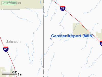
Gardner Airport (FAA LID: 88IN) is a privately owned airport located 3 miled northwest of Boggstown, Indiana, United States.
The above content comes from Wikipedia and is published under free licenses – click here to read more.
Location
& QuickFacts
|
FAA
Information Effective: |
2007-12-20 |
|
Airport
Identifier: |
88IN |
|
Airport
Status: |
Operational |
|
Longitude/Latitude: |
085-55-55.9350W/39-34-47.1710N
-85.932204/39.579770 (Estimated) |
|
Elevation: |
740 ft / 225.55 m (Estimated) |
|
Land: |
0 acres |
|
From nearest
city: |
1 nautical miles NW of Boggstown, IN |
|
Location: |
Shelby County, IN |
|
Magnetic
Variation: |
02W (1985) |
Owner & Manager
|
Ownership: |
Privately
owned |
|
Owner: |
George D. Gardner |
|
Address: |
3731 N 825 W
Boggstown, IN 46110 |
|
Phone
number: |
317-835-2409 |
|
Address: |
|
Airport
Operations and Facilities
|
Airport
Use: |
Private |
|
Wind indicator: |
No |
|
Segmented
Circle: |
No |
|
Control
Tower: |
No |
|
Landing
fee charge: |
No |
|
Sectional
chart: |
St Louis |
|
Region: |
AGL - Great Lakes |
|
Boundary
ARTCC: |
ZID - Indianapolis |
|
Tie-in
FSS: |
HUF - Terre Haute |
|
FSS on
Airport: |
No |
|
FSS Toll
Free: |
1-800-WX-BRIEF |
|
Runway Information
Runway 09/27
|
Dimension: |
1300 x 50 ft
/ 396.2 x 15.2 m |
|
Surface: |
TURF, |
|
|
Runway 09 |
Runway 27 |
|
Traffic
Pattern: |
Left |
Left |
|
Radio Navigation
Aids
|
ID |
Type |
Name |
Ch |
Freq |
Var |
Dist |
|
HFY |
NDB |
Greenwood |
|
398.00 |
02W |
8.0 nm |
|
BA |
NDB |
Clifs |
|
410.00 |
03W |
16.4 nm |
|
UMP |
NDB |
Metropolitan |
|
338.00 |
03W |
22.2 nm |
|
HZP |
NDB |
Zionsville |
|
248.00 |
03W |
26.1 nm |
|
UWL |
NDB |
New Castle |
|
385.00 |
02W |
33.6 nm |
|
HLB |
NDB |
Batesville |
|
254.00 |
02W |
34.2 nm |
|
AI |
NDB |
Video |
|
371.00 |
03W |
35.3 nm |
|
OVO |
NDB |
North Vernon |
|
374.00 |
02W |
35.4 nm |
|
TVX |
NDB |
Greencastle |
|
521.00 |
03W |
41.2 nm |
|
EQZ |
NDB |
Captain |
|
308.00 |
02W |
42.9 nm |
|
BM |
NDB |
Claye |
|
382.00 |
02W |
44.2 nm |
|
MIE |
VOR/DME |
Muncie |
091X |
114.40 |
03W |
46.7 nm |
|
SHB |
VORTAC |
Shelbyville |
057X |
112.00 |
01E |
5.9 nm |
|
VHP |
VORTAC |
Brickyard |
110X |
116.30 |
01E |
24.6 nm |
|
OOM |
VORTAC |
Hoosier |
039X |
110.20 |
02W |
41.1 nm |
|
IND |
VOT |
Indianapolis Intl |
|
109.60 |
|
18.4 nm |
Remarks
- FILED
FOR RECORD PURPOSES ONLY.
Based Aircraft
|
Aircraft
based on field: |
1 |
|
Single Engine
Airplanes: |
1 |
Gardner Airport
Address:
Shelby County, IN
Tel:
317-835-2409
Images
and information placed above are from
http://www.airport-data.com/airport/88IN/
We
thank them for the data!
| General
Info |
| Country |
United
States |
| State |
INDIANA
|
| FAA ID |
88IN |
| Latitude |
39-34-47.171N
|
| Longitude |
085-55-55.935W
|
| Elevation |
740 feet
|
| Near City |
BOGGSTOWN
|
We don't guarantee the information is fresh and accurate. The data may
be wrong or outdated.
For more up-to-date information please refer to other sources.
|
|


