 |
|
| Fulton County Airport |
| IATA: RCR â ICAO: KRCR â FAA LID: RCR |
| Summary |
| Airport type |
Public |
| Owner |
Fulton County Airport Authority |
| Location |
Rochester, Indiana |
| Elevation AMSL |
790 ft / 241 m |
| Coordinates |
41°03â²56â³N 086°10â²54â³W / 41.06556°N 86.18167°W / 41.06556; -86.18167 |
| Runways |
| Direction |
Length |
Surface |
| ft |
m |
| 11/29 |
5,001 |
1,524 |
Asphalt |
| Statistics (2006) |
| Aircraft operations |
10,097 |
| Based aircraft |
10 |
| Source: Federal Aviation Administration |
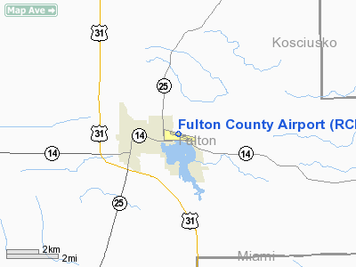
Fulton County Airport (IATA: RCR, ICAO: KRCR, FAA LID: RCR) is a public use airport located two nautical miles (4 km) east of the central business district of Rochester, a city in Fulton County, Indiana, United States. It is owned by the Fulton County Airport Authority (formerly the Fulton County Board of Aviation Commissioners).
Facilities and aircraft
Fulton County Airport covers an area of 113 acres (46 ha) at an elevation of 790 feet (241 m) above mean sea level. It has one paved runway designated 11/29 with an asphalt surface measuring 5,001 by 75 feet (1,524 x 23 m).
For the 12-month period ending December 31, 2006, the airport had 10,097 aircraft operations, an average of 27 per day: 97% general aviation and 3% air taxi. At that time there were 10 aircraft based at this airport: 90% single-engine and 10% helicopter.
The above content comes from Wikipedia and is published under free licenses – click here to read more.
Location
& QuickFacts
|
FAA
Information Effective: |
2007-12-20 |
|
Airport
Identifier: |
RCR |
|
Airport
Status: |
Operational |
|
Longitude/Latitude: |
086-10-54.1000W/41-03-55.9000N
-86.181694/41.065528 (Estimated) |
|
Elevation: |
790 ft / 240.79 m (Surveyed) |
|
Land: |
113 acres |
|
From nearest
city: |
2 nautical miles E of Rochester, IN |
|
Location: |
Fulton County, IN |
|
Magnetic
Variation: |
03W (1995) |
Owner
& Manager
|
Ownership: |
Publicly
owned |
|
Owner: |
Fulton County Airport Authority |
|
Address: |
545 State Rd 25n
Rochester, IN 46975 |
|
Phone
number: |
574-223-5384 |
|
Manager: |
Jim Ewen |
|
Address: |
545 State Rd 25n
Rochester, IN 46975 |
|
Phone
number: |
574-223-5384 |
Airport Operations
and Facilities
|
Airport
Use: |
Open
to public |
|
Wind indicator: |
Yes |
|
Segmented
Circle: |
Yes |
|
Control
Tower: |
No |
|
Lighting
Schedule: |
DUSK-DAWN
ACTVT MIRL RY 11/29, PAPI & REIL RYS 11 & 29 &
BCN - CTAF |
|
Beacon
Color: |
Clear-Green (lighted land airport) |
|
Landing
fee charge: |
No |
|
Sectional
chart: |
Chicago |
|
Region: |
AGL - Great Lakes |
|
Boundary
ARTCC: |
ZAU - Chicago |
|
Tie-in
FSS: |
HUF - Terre Haute |
|
FSS on
Airport: |
No |
|
FSS Toll
Free: |
1-800-WX-BRIEF |
|
NOTAMs
Facility: |
HUF (NOTAM-d service avaliable) |
|
Federal
Agreements: |
NY1 |
Airport Communications
|
CTAF: |
122.700 |
|
Unicom: |
122.700
|
Airport
Services
|
Runway Information
Runway 11/29
|
Dimension: |
5001 x 75 ft
/ 1524.3 x 22.9 m |
|
Surface: |
ASPH, Good Condition |
|
Surface Treatment: |
Saw-cut or plastic Grooved |
|
Weight Limit: |
Single wheel: 9000 lbs. |
|
Edge Lights: |
Medium |
|
|
Runway 11 |
Runway 29 |
|
Longitude: |
086-11-25.6451W |
086-10-22.6158W |
|
Latitude: |
41-04-02.4065N |
41-03-49.5383N |
|
Elevation: |
788.00 ft |
789.00 ft |
|
Alignment: |
105 |
127 |
|
Traffic
Pattern: |
Left |
Left |
|
Markings: |
Non-precision instrument, Fair Condition |
Non-precision instrument, Fair Condition |
|
Crossing
Height: |
28.00 ft |
28.00 ft |
|
VASI: |
2-light PAPI on left side |
2-light PAPI on left side |
|
Visual Glide
Angle: |
4.00° |
4.00° |
|
Runway End
Identifier: |
Yes |
Yes |
|
Centerline
Lights: |
No |
No |
|
Touchdown
Lights: |
No |
No |
|
Obstruction: |
25 ft tree, 760.0 ft from runway, 22:1 slope
to clear |
73 ft tree, 2900.0 ft from runway, 36:1 slope
to clear |
|
Radio Navigation
Aids
|
ID |
Type |
Name |
Ch |
Freq |
Var |
Dist |
|
RCR |
NDB |
Rochester |
|
216.00 |
03W |
0.4 nm |
|
CPB |
NDB |
Culver |
|
391.00 |
01W |
12.9 nm |
|
RWN |
NDB |
Winamac/dcmsnd |
|
335.00 |
00W |
19.2 nm |
|
GGP |
NDB |
Logansport |
|
263.00 |
01W |
23.1 nm |
|
IWH |
NDB |
Wabash |
|
329.00 |
03W |
25.2 nm |
|
MCX |
NDB |
White County |
|
377.00 |
03W |
33.9 nm |
|
HHG |
NDB |
Huntington |
|
417.00 |
03W |
34.9 nm |
|
IUL |
NDB |
La Porte |
|
356.00 |
03W |
37.3 nm |
|
VP |
NDB |
Sedly |
|
212.00 |
02W |
39.1 nm |
|
RZL |
NDB |
Rensselaer |
|
362.00 |
02W |
46.0 nm |
|
MGC |
NDB |
Michigan City |
|
203.00 |
01W |
48.0 nm |
|
OLK |
VOR |
Wolf Lake |
|
110.40 |
03W |
32.8 nm |
|
OXI |
VOR/DME |
Knox |
103X |
115.60 |
00E |
26.2 nm |
|
MZZ |
VOR/DME |
Marion |
023X |
108.60 |
03W |
41.3 nm |
|
GUS |
VORTAC |
Grissom |
21Y |
108.45 |
02W |
25.3 nm |
|
GSH |
VORTAC |
Goshen |
084X |
113.70 |
00E |
28.5 nm |
|
OKK |
VORTAC |
Kokomo |
082X |
113.50 |
00E |
32.8 nm |
|
GIJ |
VORTAC |
Gipper |
101X |
115.40 |
00E |
42.7 nm |
|
FWA |
VORTAC |
Fort Wayne |
125X |
117.80 |
00E |
45.4 nm |
|
FWA |
VOT |
Fort Wayne Baer |
|
111.00 |
|
45.2 nm |
Remarks
- ACFT
LANDING RY 11 MUST BACK TAXI.
Based Aircraft
|
Aircraft
based on field: |
15 |
|
Single Engine
Airplanes: |
14 |
|
Helicopters: |
1 |
Operational Statistics
Time
Period: 2006-01-01 - 2006-12-31
|
Aircraft
Operations: |
195/Week |
|
Air Taxi: |
3.1% |
|
General Aviation
Local: |
45.3% |
|
General Aviation
Itinerant: |
51.6% |
Fulton County Airport
Address:
Fulton County, IN
Tel:
574-223-5384
Images
and information placed above are from
http://www.airport-data.com/airport/RCR/
We
thank them for the data!
| General
Info |
| Country |
United
States |
| State |
INDIANA
|
| FAA ID |
RCR |
| Latitude |
41-03-56.000N
|
| Longitude |
086-10-54.100W
|
| Elevation |
790 feet
|
| Near City |
ROCHESTER
|
We don't guarantee the information is fresh and accurate. The data may
be wrong or outdated.
For more up-to-date information please refer to other sources.
|
|


