 |
|
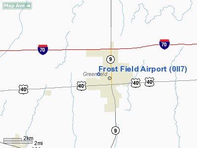
Location
& QuickFacts
|
FAA
Information Effective: |
2007-12-20 |
|
Airport
Identifier: |
0II7 |
|
Airport
Status: |
Operational |
|
Longitude/Latitude: |
085-47-09.9220W/39-47-44.1540N
-85.786089/39.795598 (Estimated) |
|
Elevation: |
900 ft / 274.32 m (Estimated) |
|
Land: |
0 acres |
|
From nearest
city: |
0 nautical miles NW of Greenfield, IN |
|
Location: |
Hancock County, IN |
|
Magnetic
Variation: |
02W (1985) |
Owner & Manager
|
Ownership: |
Privately
owned |
|
Owner: |
Robert E. Frost |
|
Address: |
784 N. Franklin
Greenfield, IN 46140 |
|
Phone
number: |
317-462-4050 |
|
Address: |
|
Airport
Operations and Facilities
|
Airport
Use: |
Private |
|
Segmented
Circle: |
No |
|
Control
Tower: |
No |
|
Sectional
chart: |
St Louis |
|
Region: |
AGL - Great Lakes |
|
Boundary
ARTCC: |
ZID - Indianapolis |
|
Tie-in
FSS: |
HUF - Terre Haute |
|
FSS on
Airport: |
No |
|
FSS Toll
Free: |
1-800-WX-BRIEF
OR LOCAL CALL 244-3316. |
|
Runway Information
Runway N/S
|
Dimension: |
2500 x 100 ft
/ 762.0 x 30.5 m |
|
Surface: |
TURF, |
|
|
Runway N |
Runway S |
|
Traffic
Pattern: |
Left |
Right |
|
Obstruction: |
|
30 ft pline, 480.0 ft from runway |
|
Radio Navigation
Aids
|
ID |
Type |
Name |
Ch |
Freq |
Var |
Dist |
|
UMP |
NDB |
Metropolitan |
|
338.00 |
03W |
14.9 nm |
|
HFY |
NDB |
Greenwood |
|
398.00 |
02W |
17.2 nm |
|
AI |
NDB |
Video |
|
371.00 |
03W |
20.8 nm |
|
UWL |
NDB |
New Castle |
|
385.00 |
02W |
22.2 nm |
|
HZP |
NDB |
Zionsville |
|
248.00 |
03W |
23.1 nm |
|
BA |
NDB |
Clifs |
|
410.00 |
03W |
28.5 nm |
|
HLB |
NDB |
Batesville |
|
254.00 |
02W |
36.3 nm |
|
OVO |
NDB |
North Vernon |
|
374.00 |
02W |
45.6 nm |
|
FKR |
NDB |
Frankfort |
|
278.00 |
02W |
45.7 nm |
|
TVX |
NDB |
Greencastle |
|
521.00 |
03W |
47.4 nm |
|
OXD |
NDB |
Oxford |
|
282.00 |
04W |
49.6 nm |
|
MIE |
VOR/DME |
Muncie |
091X |
114.40 |
03W |
32.1 nm |
|
MZZ |
VOR/DME |
Marion |
023X |
108.60 |
03W |
42.2 nm |
|
SHB |
VORTAC |
Shelbyville |
057X |
112.00 |
01E |
10.0 nm |
|
VHP |
VORTAC |
Brickyard |
110X |
116.30 |
01E |
26.9 nm |
|
RID |
VORTAC |
Richmond |
043X |
110.60 |
03W |
43.8 nm |
|
OKK |
VORTAC |
Kokomo |
082X |
113.50 |
00E |
45.7 nm |
|
IND |
VOT |
Indianapolis Intl |
|
109.60 |
|
23.4 nm |
Remarks
- FILED
FOR RECORD PURPOSES ONLY.
Based Aircraft
|
Aircraft
based on field: |
3 |
|
Single Engine
Airplanes: |
3 |
Frost Field Airport
Address:
Hancock County, IN
Tel:
317-462-4050
Images
and information placed above are from
http://www.airport-data.com/airport/0II7/
We
thank them for the data!
| General
Info |
| Country |
United
States |
| State |
INDIANA
|
| FAA ID |
0II7 |
| Latitude |
39-47-44.154N
|
| Longitude |
085-47-09.922W
|
| Elevation |
900 feet
|
| Near City |
GREENFIELD
|
We don't guarantee the information is fresh and accurate. The data may
be wrong or outdated.
For more up-to-date information please refer to other sources.
|
|


