 |
|
French Lick Municipal Airport |
| French Lick Municipal Airport |
| IATA: FRH â ICAO: KFRH â FAA LID: FRH |
| Summary |
| Airport type |
Public |
| Owner |
French Lick Board of Aviation Commissioners |
| Serves |
French Lick, Indiana |
| Elevation AMSL |
792 ft / 241 m |
| Coordinates |
38°30â²22â³N 086°38â²13â³W / 38.50611°N 86.63694°W / 38.50611; -86.63694 |
| Website |
FrenchLickAirport.com |
| Runways |
| Direction |
Length |
Surface |
| ft |
m |
| 8/26 |
5,500 |
1,676 |
Asphalt |
| Statistics (2007) |
| Aircraft operations |
8,795 |
| Based aircraft |
18 |
| Source: Federal Aviation Administration |
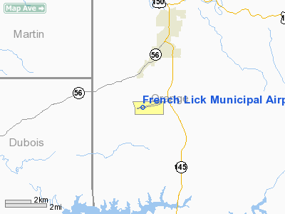
French Lick Municipal Airport (IATA: FRH, ICAO: KFRH, FAA LID: FRH) is a city-owned public-use airport located three nautical miles (6 km) southwest of the central business district of French Lick, a town in Orange County, Indiana, United States. Also known as French Lick Airport, it serves the French Lick and West Baden, Indiana area.
In March 2009, the airport began construction of a new terminal that will measure 3,434 square feet (319 m), nearly five times the size of the current terminal. Grants were provided by The Indiana Economic Development Corp. ($300,000) and the Orange County Development Commission ($250,000).
Facilities and aircraft
French Lick Municipal Airport covers an area of 422 acres (171 ha) at an elevation of 792 feet (241 m) above mean sea level. It has one asphalt paved runway designated 8/26 which measures 5,500 by 100 feet (1,676 x 30 m).
For the 12-month period ending December 31, 2007, the airport had 8,795 aircraft operations, an average of 24 per day: 94% general aviation, 5% air taxi and 1% military. At that time there were 18 aircraft based at this airport: 61% single-engine and 39% ultralight.
The above content comes from Wikipedia and is published under free licenses – click here to read more.
Location
& QuickFacts
|
FAA
Information Effective: |
2007-12-20 |
|
Airport
Identifier: |
FRH |
|
Airport
Status: |
Operational |
|
Longitude/Latitude: |
086-38-12.9670W/38-30-22.3970N
-86.636935/38.506221 (Estimated) |
|
Elevation: |
792 ft / 241.40 m (Surveyed) |
|
Land: |
422 acres |
|
From nearest
city: |
3 nautical miles SW of French Lick, IN |
|
Location: |
Orange County, IN |
|
Magnetic
Variation: |
02W (1995) |
Owner
& Manager
|
Ownership: |
Publicly
owned |
|
Owner: |
French Lick Boac |
|
Address: |
Po Box 10
French
Lick, IN 47432 |
|
Phone
number: |
812-936-4737 |
|
Manager: |
Nicholas Goodman |
|
Address: |
9369 West Co Rd 25 S.
French Lick, IN 47432 |
|
Phone
number: |
812-936-2222 |
Airport Operations
and Facilities
|
Airport
Use: |
Open
to public |
|
Wind indicator: |
Yes |
|
Segmented
Circle: |
No |
|
Control
Tower: |
No |
|
Lighting
Schedule: |
DUSK-DAWN
ACTVT MIRL RY 08/26 - CTAF. |
|
Beacon
Color: |
Clear-Green (lighted land airport) |
|
Landing
fee charge: |
No |
|
Sectional
chart: |
St Louis |
|
Region: |
AGL - Great Lakes |
|
Boundary
ARTCC: |
ZID - Indianapolis |
|
Tie-in
FSS: |
HUF - Terre Haute |
|
FSS on
Airport: |
No |
|
FSS Toll
Free: |
1-800-WX-BRIEF |
|
NOTAMs
Facility: |
HUF (NOTAM-d service avaliable) |
|
Federal
Agreements: |
NGY |
Airport Communications
|
CTAF: |
122.800 |
|
Unicom: |
122.800
|
Airport
Services
|
Fuel
available: |
100LLA |
|
Airframe
Repair: |
MAJOR |
|
Power
Plant Repair: |
MINOR |
|
Bottled
Oxygen: |
NONE |
|
Bulk Oxygen: |
NONE |
|
Runway Information
Runway 08/26
|
Dimension: |
5500 x 100 ft
/ 1676.4 x 30.5 m |
|
Surface: |
ASPH, Fair Condition |
|
Weight Limit: |
Single wheel: 50000 lbs.
Dual wheel: 60000 lbs. |
|
Edge Lights: |
Medium |
|
|
Runway 08 |
Runway 26 |
|
Longitude: |
086-38-46.5600W |
086-37-39.4600W |
|
Latitude: |
38-30-15.7800N |
38-30-29.0300N |
|
Elevation: |
791.00 ft |
784.00 ft |
|
Alignment: |
76 |
127 |
|
ILS Type: |
|
SDF |
|
Traffic
Pattern: |
Left |
Left |
|
Markings: |
Non-precision instrument, Good Condition |
Non-precision instrument, Good Condition |
|
Crossing
Height: |
36.00 ft |
38.00 ft |
|
VASI: |
4-box on left side |
4-box on left side |
|
Visual Glide
Angle: |
3.00° |
3.00° |
|
Runway End
Identifier: |
No |
Yes
RY 26 REIL OUT OF SERVICE INDEFINITELY. |
|
Centerline
Lights: |
No |
No |
|
Touchdown
Lights: |
No |
No |
|
Obstruction: |
14 ft trees, 840.0 ft from runway, 45:1 slope
to clear |
14 ft trees, 201.0 ft from runway
RY 26 +10 FT TREES; 140 FT FROM RWY END. |
|
Radio Navigation
Aids
|
ID |
Type |
Name |
Ch |
Freq |
Var |
Dist |
|
RRJ |
NDB |
Oranj |
|
368.00 |
02W |
5.3 nm |
|
FNZ |
NDB |
Ferdinand |
|
239.00 |
00E |
18.1 nm |
|
BFR |
NDB |
Bedford |
|
344.00 |
02W |
22.1 nm |
|
DCY |
NDB |
Washington |
|
212.00 |
03W |
25.9 nm |
|
TEL |
NDB |
Tell City |
|
206.00 |
02W |
29.7 nm |
|
BM |
NDB |
Claye |
|
382.00 |
02W |
33.1 nm |
|
EQZ |
NDB |
Captain |
|
308.00 |
02W |
38.0 nm |
|
OEA |
NDB |
Vincennes |
|
251.00 |
00E |
44.6 nm |
|
GOI |
NDB |
Godman |
|
396.00 |
02W |
45.3 nm |
|
MYS |
VOR |
Mystic |
|
108.20 |
01W |
41.2 nm |
|
HNB |
VOR/DME |
Huntingburg |
029X |
109.20 |
00E |
21.5 nm |
|
FTK |
VOR/DME |
Fort Knox |
033X |
109.60 |
01W |
47.7 nm |
|
LWV |
VOR/DME |
Lawrenceville |
025X |
108.80 |
01W |
48.1 nm |
|
BQM |
VOR/DME |
Bowman |
059X |
112.20 |
01W |
48.7 nm |
|
OOM |
VORTAC |
Hoosier |
039X |
110.20 |
02W |
38.3 nm |
|
ABB |
VORTAC |
Nabb |
071X |
112.40 |
01E |
47.3 nm |
|
SDF |
VOT |
Louisville Standifd |
|
111.00 |
|
46.8 nm |
Remarks
Based Aircraft
|
Aircraft
based on field: |
18 |
|
Single Engine
Airplanes: |
11 |
|
Ultralights: |
7 |
Operational Statistics
Time
Period: 2004-06-21 - 2005-06-20
|
Aircraft
Operations: |
135/Week |
|
Air Taxi: |
5.1% |
|
General Aviation
Local: |
66.4% |
|
General Aviation
Itinerant: |
27.8% |
|
Military: |
0.7% |
French Lick Municipal Airport
Address:
Orange County, IN
Tel:
812-936-4737,
812-936-2222
Images
and information placed above are from
http://www.airport-data.com/airport/FRH/
We
thank them for the data!
| General
Info |
| Country |
United
States |
| State |
INDIANA
|
| FAA ID |
FRH |
| Latitude |
38-30-22.397N
|
| Longitude |
086-38-12.967W
|
| Elevation |
792 feet
|
| Near City |
FRENCH
LICK |
We don't guarantee the information is fresh and accurate. The data may
be wrong or outdated.
For more up-to-date information please refer to other sources.
|
|


