Freeman Municipal Airport in Indiana Indiana airports - Freeman Municipal Airport
Freeman Municipal Airport in Indiana - United States
Indiana Airports
USA Airports
World Airports
Airport photos
Aircraft photos
Spacecraft photos
Earth from airplane
Earth from space
Aviation Articles

Freeman Municipal Airport


Freeman Municipal Airport
1998 USGS airphoto
IATA: SER – ICAO: KSER – FAA LID: SER
Summary
Airport type Public
Owner Seymour Airport Authority
Serves Seymour, Indiana
Location Seymour, Indiana
Elevation AMSL 583 ft / 178 m
Coordinates 38°55′29″N 085°54′30″W / 38.92472°N 85.90833°W / 38.92472; -85.90833
Runways
Direction Length Surface
ft m
5/23 5,500 1,676 Asphalt
14/32 5,502 1,677 Asphalt
9U/27U 1,000 305 Turf
18U/36U 1,200 366 Turf
Statistics (2006)
Aircraft operations 14,277
Based aircraft 80
Source: Federal Aviation Administration


Freeman Field historical marker

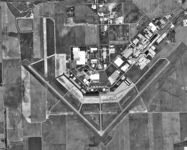
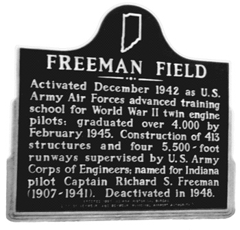
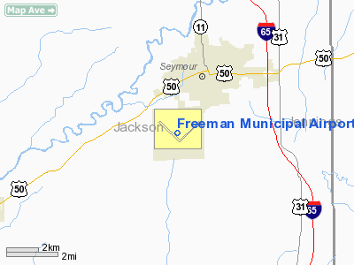
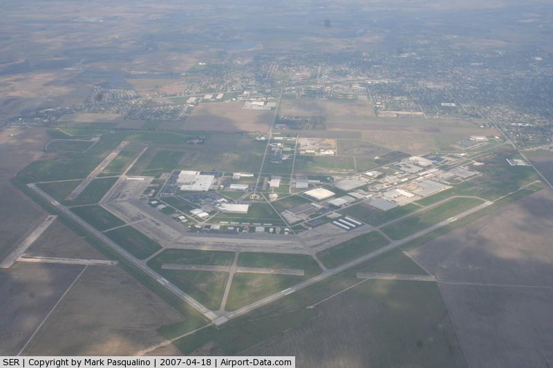
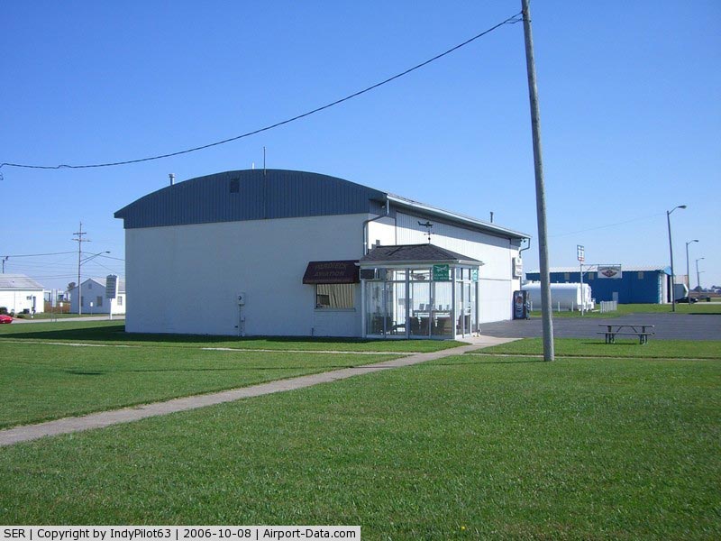
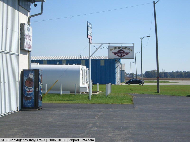
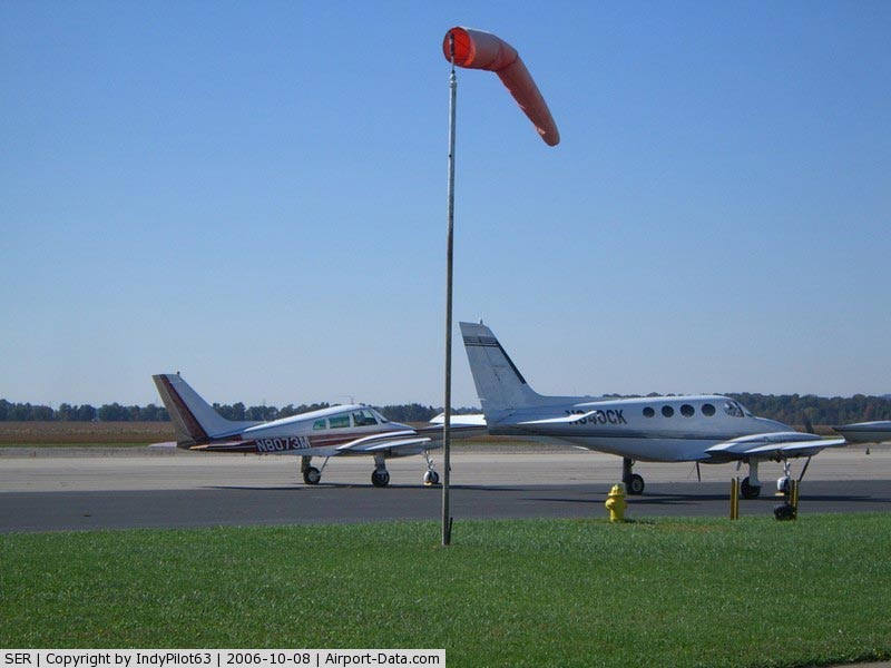
Freeman Municipal Airport (IATA: SER, ICAO: KSER, FAA LID: SER) is a public use airport located two nautical miles (4 km) southwest of the central business district of Seymour, a city in Jackson County, Indiana, United States. It is owned by the Seymour Airport Authority.

Facilities and aircraft

Freeman Municipal Airport covers an area of 2,100 acres (850 ha) at an elevation of 583 feet (178 m) above mean sea level. It has two asphalt paved runways: 5/23 is 5,500 by 100 feet (1,676 x 30 m) and 14/32 is 5,502 by 100 feet (1,677 x 30 m) . It also has two turf runways: 9U/27U is 1,000 by 100 feet (305 x 30 m) is 18U/36U is 1,200 by 100 feet (366 x 30 m).

For the 12-month period ending December 31, 2006, the airport had 14,277 aircraft operations, an average of 39 per day: 77% general aviation, 21% air taxi, 1% military. At that time there were 80 aircraft based at this airport: 71% single-engine, 9% multi-engine, 1% helicopter and 19% ultralight.

History

Flying Training

Established by the United States Army Air force in 1942. Activated on 1 December as Freeman Army Airfield It was named to honor Captain Richard S. Freeman, a 1930 graduate of West Point. Captain Freeman helped establish Ladd Field which is today's Wainwright Army Base just outside Fairbanks, Alaska. He was Ladd Field's first commander. Freeman Field had four 5,500' hard all-weather runways and seven axillary airfields for emergency and overflow landings/takeoffs. Conducted Advanced twin-engine flying training (33d Twin Engine Flying Training Group). Many of the graduates went on to fly bombers, such as B-17s and B-24s. The last graduation was February 1, 1945. A total of 4,245 pilots graduated from the Freeman Field aerial training base. Twenty-four instructors and cadets were killed during training.

Became first USAAF helicopter training school in June 1944. Continued training until October when AAFTC moved the training to Chanute Field, Illinois, so it could consolidate the flying training operation with helicopter mechanic training.

Freeman Field Mutiny

Black aviators, including a group of Tuskegee Airmen, trained at Freeman Field. In April 1945, black officers tried to integrate an officers' club resulting in what became known as the "Freeman Field Mutiny". The mutiny is generally regarded by historians of the Civil Rights Movement as an important step toward full integration of the armed forces and as a model for later efforts to integrate public facilities through civil disobedience.

Foreign Aircraft Storage

After the end of World War II, Feeeman AAF became a storage depot of many captured German and Italian aircraft (Operation Lusty). Training at the field had stopped and it became the site for the storage of American and foreign aircraft.

In 1945 the enemy aircraft shipped to the United States were divided between the Navy and the Army Air Forces. General Hap Arnold ordered the preservation of one of every type of aircraft used by the enemy forces. The Air Force brought their aircraft to Wright Field, and when the field could no longer handle additional aircraft, many were sent to Freeman Field to the foreign technology evaluation center established there. Most of the foreign airplanes were German, but there were also Japanese, Italian and English planes. Nowhere in the United States would there be such large numbers of foreign aircraft, many of which were rare and incredible advanced for their time, In addition, there were warehouses full of Luftwaffe equipment. Forty-seven personnel were engaged in the identification, inspection and warehousing of captured foreign equipment. Freeman Field was also charged with the mission to receive and catalogue U. S. equipment for display at the present and for the future AAF museum.

In 1946 when Freeman Field was scheduled to close, Air Technical Service Command had to move the aircraft. The larger aircraft were sent to Davis-Monthan Field, Arizona, and the fighter aircraft sent to the Special Depot, Park Ridge, Ill. (now O'Hare Airport), which was under the control of ATSC's Office of Intelligence. Many of the captured aircraft which were not moved were destroyed or buried. Freeman Field was closed and declared surplus on 30 December 1946. It was deactivated in November 1948. The War Assets Administration determined the post-war use of the land and structures: 2,241 acres for a municipal airport for Seymour; more than 240 acres for agricultural training in the Seymour Community Schools; and the Seymour Industrial Association received more than sixty acres to develop an industrial park.

Examples of aircraft that have no record of leaving Freeman Field are a Dornier Do 335 experimental interceptor; a Heinkel He 219 RADAR-equipped night fighter; an Arado Ar 234 twin-engined jet bomber, two Messerschmitt Me 163 rocket-powered interceptors, two Focke-Wulf Fw 190 interceptors and a Junkers Ju 88 two-engine multi-role aircraft. Today, several groups are engaged in locating and recovering any aviation artifacts from the aircraft which were destroyed and buried in 1946. The groups are currently in communication with former base personnel, local eyewitnesses, and historians in order to get a comprehensive picture of where the burial pits are located and what items were put in them.


The above content comes from Wikipedia and is published under free licenses – click here to read more.

Freeman Municipal Airport picture

Freeman Municipal Airport picture
(Click on the photo to enlarge)


Freeman Municipal Airport picture
(Click on the photo to enlarge)


Freeman Municipal Airport picture
(Click on the photo to enlarge)


Freeman Municipal Airport picture
(Click on the photo to enlarge)


Location & QuickFacts

FAA Information Effective:

2007-12-20

Airport Identifier:

SER

Airport Status:

Operational

Longitude/Latitude:

085-54-30.0740W/38-55-28.9160N
-85.908354/38.924699 (Estimated)

Elevation:

583 ft / 177.70 m (Surveyed)

Land:

2100 acres

From nearest city:

2 nautical miles SW of Seymour, IN

Location:

Jackson County, IN

Magnetic Variation:

02W (1985)

Owner & Manager

Ownership:

Publicly owned

Owner:

Seymour Airport Authority

Address:

P.o. Box 702
Seymour, IN 47274

Phone number:

812-522-2031

Manager:

Don Furlow

Address:

P.o. Box 702
Seymour, IN 47274

Phone number:

812-522-2031

Airport Operations and Facilities

Airport Use:

Open to public

Wind indicator:

Yes

Segmented Circle:

Yes

Control Tower:

No

Lighting Schedule:

DUSK-DAWN
MIRL RYS 05/23 & 14/32 PRESET ON OFF ; TO ACTVT & INCR INTST REIL RYS 05, 23, 14 & 32, & ODALS RYS 05 & 23 PAPI RYS 05 & 23 - CTAF.

Beacon Color:

Clear-Green (lighted land airport)

Landing fee charge:

No

Sectional chart:

St Louis

Region:

AGL - Great Lakes

Boundary ARTCC:

ZID - Indianapolis

Tie-in FSS:

HUF - Terre Haute

FSS on Airport:

No

FSS Toll Free:

1-800-WX-BRIEF

NOTAMs Facility:

HUF (NOTAM-d service avaliable)

Federal Agreements:

NGPY

Airport Communications

CTAF:

122.800

Unicom:

122.800 

Airport Services

Fuel available:

100LLA

Airframe Repair:

MINOR

Power Plant Repair:

MINOR

Bottled Oxygen:

NONE

Bulk Oxygen:

NONE

Runway Information

Runway 05/23

Dimension:

5500 x 100 ft / 1676.4 x 30.5 m
RWY 27U CROPS 200'AND 36'HIGH POWERLINE 582' FROM EAST END.
CRACKING & LOOSE GRVL.

Surface:

ASPH, Good Condition

Surface Treatment:

Saw-cut or plastic Grooved

Weight Limit:

Single wheel: 20000 lbs.
Dual wheel: 35000 lbs.
Dual tandem wheel: 50000 lbs.

Edge Lights:

Medium


Runway 05

Runway 23

Longitude:

085-54-26.7930W

085-53-38.3750W

Latitude:

38-55-05.5180N

38-55-44.5670N

Elevation:

571.00 ft

580.00 ft

Alignment:

44

127

ILS Type:

LOCALIZER


Traffic Pattern:

Left

Left

Markings:

Non-precision instrument, Fair Condition

Non-precision instrument, Fair Condition

Crossing Height:

29.00 ft

28.00 ft

VASI:

2-light PAPI on left side

2-light PAPI on left side

Visual Glide Angle:

3.00°

3.00°

Approach lights:

ODALS

ODALS

Runway End Identifier:

Yes

Yes

Centerline Lights:

No

No

Touchdown Lights:

No

No


Runway 09U/27U

Dimension:

1000 x 100 ft / 304.8 x 30.5 m
RWY 27U CROPS 200'AND 36'HIGH POWERLINE 582' FROM EAST END.
CRACKING & LOOSE GRVL.

Surface:

TURF,


Runway 09U

Runway 27U

Longitude:

085-54-50.9830W

085-54-38.3320W

Latitude:

38-55-52.9860N

38-55-52.9800N

Alignment:

90

127

Traffic Pattern:

Left

Left

Displaced threshold:

0.00 ft

120.00 ft

Centerline Lights:


No

Obstruction:

55 ft bldg, 1200.0 ft from runway, 300 ft left of centerline, 21:1 slope to clear

30 ft pline, 700.0 ft from runway, 23:1 slope to clear


Runway 14/32

Dimension:

5502 x 100 ft / 1677.0 x 30.5 m
RWY 27U CROPS 200'AND 36'HIGH POWERLINE 582' FROM EAST END.
CRACKING & LOOSE GRVL.

Surface:

ASPH, Good Condition

Surface Treatment:

Saw-cut or plastic Grooved

Weight Limit:

Single wheel: 20000 lbs.
Dual wheel: 35000 lbs.
Dual tandem wheel: 50000 lbs.

Edge Lights:

Medium


Runway 14

Runway 32

Longitude:

085-55-15.4580W

085-54-25.4600W

Latitude:

38-55-43.3800N

38-55-05.5360N

Elevation:

583.00 ft

571.00 ft

Alignment:

127

127

Traffic Pattern:

Left

Left

Markings:

Non-precision instrument, Fair Condition

Non-precision instrument, Fair Condition

Crossing Height:

21.00 ft

30.00 ft

VASI:

2-light PAPI on left side

2-light PAPI on left side

Visual Glide Angle:

3.00°

3.00°

Runway End Identifier:

Yes

Yes

Centerline Lights:

No

No

Touchdown Lights:

No

No

Obstruction:

10 ft crops, 434.0 ft from runway, 23:1 slope to clear

7 ft crops, 513.0 ft from runway, 44:1 slope to clear


Runway 18U/36U

Dimension:

1200 x 100 ft / 365.8 x 30.5 m
RWY 27U CROPS 200'AND 36'HIGH POWERLINE 582' FROM EAST END.
CRACKING & LOOSE GRVL.

Surface:

TURF, Fair Condition


Runway 18U

Runway 36U

Longitude:

085-54-50.4560W

085-54-50.4560W

Latitude:

38-55-52.9860N

38-55-41.1250N

Alignment:

127

0

Traffic Pattern:

Left

Right

Markings:

Basic, Good Condition

Basic, Good Condition
RWY 36U END UNMARKED.

Displaced threshold:

200.00 ft

400.00 ft

Obstruction:

10 ft , 200.0 ft from runway
RWY 18U 33:1 FROM DSPLCD THR.
CROPS 130' FM RWY END.

20 ft bldg, 550.0 ft from runway, 30 ft right of centerline, 27:1 slope to clear


Radio Navigation Aids

ID

Type

Name

Ch

Freq

Var

Dist

EQZ

NDB

Captain


308.00

02W

4.6 nm

OVO

NDB

North Vernon


374.00

02W

16.2 nm

IMS

NDB

Madison


404.00

03W

23.2 nm

BA

NDB

Clifs


410.00

03W

24.2 nm

BFR

NDB

Bedford


344.00

02W

25.3 nm

BM

NDB

Claye


382.00

02W

33.2 nm

RRJ

NDB

Oranj


368.00

02W

37.6 nm

HLB

NDB

Batesville


254.00

02W

39.7 nm

HFY

NDB

Greenwood


398.00

02W

43.4 nm

BQM

VOR/DME

Bowman

059X

112.20

01W

43.3 nm

ABB

VORTAC

Nabb

071X

112.40

01E

23.9 nm

OOM

VORTAC

Hoosier

039X

110.20

02W

35.4 nm

SHB

VORTAC

Shelbyville

057X

112.00

01E

42.7 nm

SDF

VOT

Louisville Standifd


111.00


45.6 nm

Remarks

  • RDO CTLD AIRPLANES OPERATING ON & INVOF ARPT DLY FM APR - OCT.

Based Aircraft

Aircraft based on field:

70

Single Engine Airplanes:

49

Multi Engine Airplanes:

5

Helicopters:

1

Ultralights:

15

Operational Statistics

    Time Period: 2006-01-01 - 2006-12-31

Aircraft Operations:

275/Week

Air Taxi:

21.4%

General Aviation Local:

56.8%

General Aviation Itinerant:

20.5%

Military:

1.3%


Freeman Municipal Airport

Address: Jackson County, IN

Tel: 812-522-2031


Images and information placed above are from
http://www.airport-data.com/airport/SER/

We thank them for the data!


General Info
Country United States
State INDIANA
FAA ID SER
Latitude 38-55-24.793N
Longitude 085-54-26.516W
Elevation 583 feet
Near City SEYMOUR


We don't guarantee the information is fresh and accurate. The data may be wrong or outdated.
For more up-to-date information please refer to other sources.


christianity portal
directory of hotels worldwide


Copyright 2004-2024 © by Airports-Worldwide.com, Vyshenskoho st. 36, Lviv 79010, Ukraine
Legal Disclaimer