|
|
Fort Wayne International Airport |
| Fort Wayne International Airport |
 |
 |
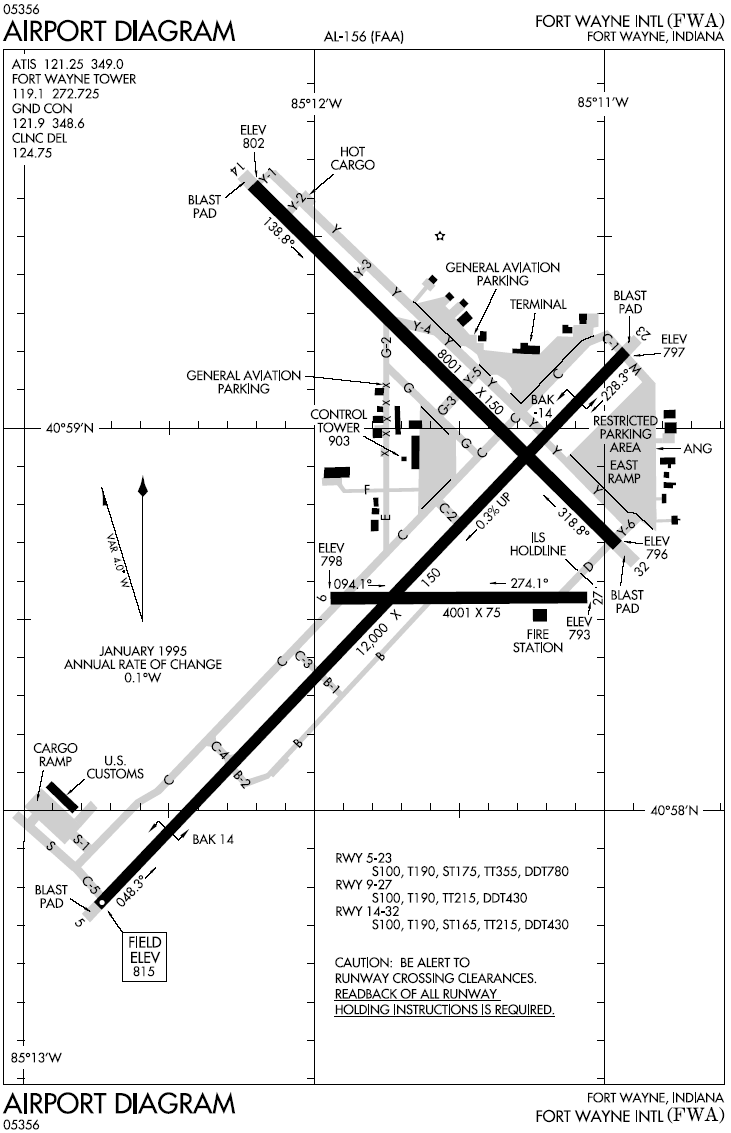
| FAA airport diagram |
| IATA: FWA â ICAO: KFWA â FAA LID: FWA |
| Summary |
| Airport type |
Public |
| Owner |
Fort Wayne/Allen County Airport Authority |
| Location |
3801 West Ferguson Road
Fort Wayne, Indiana, United States |
| Elevation AMSL |
815 ft / 248 m |
| Coordinates |
40°58â²42â³N 085°11â²42â³W / 40.97833°N 85.195°W / 40.97833; -85.195 |
| Website |
www.flyfwa.com |
| Runways |
| Direction |
Length |
Surface |
| ft |
m |
| 5/23 |
12,000 |
3,658 |
Asphalt/Concrete |
| 9/27 |
4,001 |
1,220 |
Asphalt/Concrete |
| 14/32 |
8,001 |
2,439 |
Asphalt/Concrete |
| Source: Federal Aviation Administration |
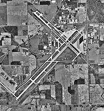
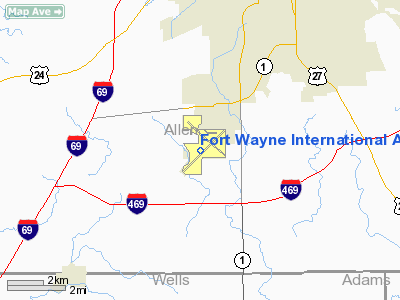
Fort Wayne International Airport (IATA: FWA, ICAO: KFWA, FAA LID: FWA) is a joint civil-military public airport located seven miles (11 km) southwest of the central business district of Fort Wayne, in Allen County, Indiana, United States. This airport is publicly owned by Fort Wayne/Allen County Airport Authority.
The airport contains one terminal, the Lieutenant Paul Baer Terminal. Passenger service is offered to five larger airline hubs of Atlanta, Chicago, Cincinnati, Dallas-Fort Worth, and Detroit, annually serving approximately 650,000 passengers. The airport has a 600,000-square-foot (56,000 m) air cargo center located on the southwest side. The center was occupied by Kitty Hawk Aircargo, which operated a hub and spoke operation out of Fort Wayne until October 30, 2007, shortly after the carrier filed for Chapter 11 bankruptcy. Fort Wayne International is also home to a maintenance base for Pinnacle Airlines. Airlines and destinations
Fort Wayne International Airport has eight common-use gates. Gates 1-4 are ground-level and are boarded via airstairs, whereas Gates 5-8 board via jetways.
| Airlines |
Destinations |
| Allegiant Air |
Myrtle Beach, Orlando-Sanford, St. Petersburg/Clearwater |
| American Eagle |
Dallas/Fort Worth |
| AmericanConnection operated by Chautauqua Airlines |
Chicago-O'Hare |
| Delta Connection operated by Atlantic Southeast Airlines |
Atlanta |
| Delta Connection operated by Comair |
Cincinnati/Northern Kentucky |
| Delta Connection operated by Pinnacle Airlines |
Atlanta, Cincinnati/Northern Kentucky, Detroit, Minneapolis/St. Paul |
| United Express operated by SkyWest Airlines |
Chicago-O'Hare |
Military and airfield infrastructureFort Wayne International Airport is homebase to the Fort Wayne Air National Guard Station and the 122d Fighter Wing (122 FW) of the Indiana Air National Guard. Nicknamed the "Blacksnakes," the 122 FW is an Air National Guard fighter unit operationally gained by the Air Combat Command (ACC). The 122 FW flies the F-16C/D Fighting Falcon from Fort Wayne AGS, which is located on the east side of the airport in a secure area away from the publicly accessible facilities. The current military installation that makes up Fort Wayne AGS was occupied by the 122 FW in 1954.
As of 2006, the airport's main Runway 5/23's usable dimensions are 11,981 feet (3,652 m) long and 150 feet (46 m) wide while the grooved-surface dimensions are 12,000 feet (3,700 m) long and 150 feet (46 m) wide, large enough to accommodate the NASA Space Shuttle orbiter, Boeing 747s, and military air mobility and aerial refueling aircraft such as the C-5 Galaxy, C-17 Globemaster III, KC-135 Stratotanker and KC-10 Extender. The runway is also equipped with BAK-14 arresting gear on both ends for emergency arrestment of US and NATO/Allied fighter and other similar-sized tactical fixed-wing aircraft.
History
 | |
Baer Field on 8 April 1988. |
The airport was originally constructed at a cost of $10 million as a U.S. Army Air Forces base during World War II, opening in 1941 under the name Baer Field and later Baer Army Air Field. During wartime, over 100,000 military personnel served out of Baer Field and its more than 100 structures. The principal units at the installation were the First Troop Carrier Group and the 45th Army Air Force Base Unit. By the end of World War II, the city of Fort Wayne bought the airport from the federal government's General Services Administration for the price of $1, renaming it Fort Wayne Municipal Airport in 1946.
Under the management of the Fort Wayne/Allen County Airport Authority since 1985, the airport was renamed Fort Wayne International Airport in 1991. Through the 1990s, the airport underwent the largest expansion and revitalization in its history, with an expanded and updated terminal, runway upgrades, and the establishment of the Air Trade Center on the southwest side of the property. In 2006, a modernized 210 feet (64 m) air traffic control tower was opened on the south side of the airport, at a price of $9.7 million.
Located in the Lieuteant Paul Baer Terminal, the Greater Fort Wayne Aviation Museum recounts early aviation history in Northeastern Indiana.
Incidents
- In late 2003, Charles McKinley shipped himself via Kitty Hawk Air Cargo from Newark International Airport to Buffalo, New York, then to Fort Wayne, eventually flying to Dallas-Fort Worth International Airport, undetected through security.
- On August 18, 2004, Fort Wayne International Airport was in the national spotlight after a mysterious "liquid substance" discovered leaking from luggage forced authorities to shut down the airport, when six people fell ill. Fearing that the incident may have been an act of terrorism, the FBI was involved in the investigation. Later in the day, Haz-mat ruled that there was "no biological or chemical threat" and the airport was reopened that afternoon. All who were ill recovered and it was later revealed that the substance was an agent for producing perfume.
The above content comes from Wikipedia and is published under free licenses – click here to read more.
|
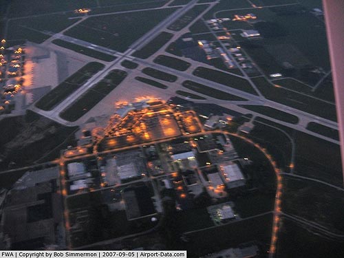 |
(Click on the photo to enlarge) |
Location
& QuickFacts
|
FAA
Information Effective: |
2007-12-20 |
|
Airport
Identifier: |
FWA |
|
Airport
Status: |
Operational |
|
Longitude/Latitude: |
085-11-42.5000W/40-58-42.5000N
-85.195139/40.978472 (Estimated) |
|
Elevation: |
815 ft / 248.41 m (Surveyed) |
|
Land: |
3351 acres |
|
From nearest
city: |
7 nautical miles SW of Fort Wayne, IN |
|
Location: |
Allen County, IN |
|
Magnetic
Variation: |
03W (1985) |
Owner
& Manager
|
Ownership: |
Publicly
owned |
|
Owner: |
Ft Wayne/allen Co Arpt Auth |
|
Address: |
Suite 209-lt Paul Baer Term.
Fort
Wayne, IN 46809 |
|
Phone
number: |
260-747-4146 |
|
Manager: |
Torrance A. Richardson |
|
Address: |
Suite 209-lt Paul Baer Term.
Fort Wayne, IN 46809 |
|
Phone
number: |
260-747-4146 |
Airport
Operations and Facilities
|
Airport
Use: |
Open
to public |
|
Wind indicator: |
Yes |
|
Segmented
Circle: |
No |
|
Control
Tower: |
Yes |
|
Lighting
Schedule: |
ATC-CTL |
|
Beacon
Color: |
Clear-Green (lighted land airport) |
|
Landing
fee charge: |
No |
|
Sectional
chart: |
Chicago |
|
Region: |
AGL - Great Lakes |
|
Boundary
ARTCC: |
ZAU - Chicago |
|
Tie-in
FSS: |
HUF - Terre Haute |
|
FSS on
Airport: |
No |
|
FSS Toll
Free: |
1-800-WX-BRIEF |
|
NOTAMs
Facility: |
FWA (NOTAM-d service avaliable) |
|
Certification
type/date: |
I B S 05/1973
ARFF INDEX C AVBL UPON REQ CALL AMGR 260-747-4146. |
|
Federal
Agreements: |
NGPY3 |
Airport
Communications
Airport
Services
|
Fuel
available: |
100LLA
CALLOUT FEE FOR FUEL IMPOSED BETWEEN 0000-0500. |
|
Airframe
Repair: |
MAJOR |
|
Power
Plant Repair: |
MAJOR |
|
Bottled
Oxygen: |
HIGH |
|
Runway
Information
Runway
05/23
|
Dimension: |
11981 x 150
ft / 3651.8 x 45.7 m |
|
Surface: |
ASPH-CONC, Good Condition |
|
Surface Treatment: |
Saw-cut or plastic Grooved
GRVD 11,981 X 130.
GRVD 8000 FT BY 130 FT. |
|
Weight Limit: |
Single wheel: 100000 lbs.
Dual wheel: 190000 lbs.
Dual tandem wheel: 355000 lbs.
Dual dual tandem wheel: 780000 lbs. |
|
Edge Lights: |
High |
|
|
Runway
05 |
Runway
23 |
|
Longitude: |
085-12-45.6932W |
085-10-56.6930W |
|
Latitude: |
40-57-45.6734N |
40-59-10.4440N |
|
Elevation: |
814.00 ft |
0.00 ft |
|
Alignment: |
44 |
127 |
|
ILS Type: |
ILS |
|
|
Traffic
Pattern: |
Left |
Left |
|
Markings: |
Precision instrument, Good Condition |
Precision instrument, Good Condition |
|
Arresting: |
BAK14 |
BAK12 |
|
Crossing
Height: |
0.00 ft |
76.00 ft |
|
VASI: |
|
4-light PAPI on left side |
|
Visual Glide
Angle: |
0.00° |
3.00° |
|
RVR Equipment: |
touchdown, midfield, rollout |
touchdown, midfield, rollout |
|
Approach
lights: |
ALSF2 |
|
|
Runway End
Identifier: |
|
Yes |
|
Centerline
Lights: |
Yes |
Yes |
|
Touchdown
Lights: |
Yes |
No |
|
Obstruction: |
, 50:1 slope to clear |
51 ft tree, 1900.0 ft from runway, 300 ft left
of centerline, 33:1 slope to clear |
|
Runway
09/27
|
Dimension: |
4001 x 75 ft
/ 1219.5 x 22.9 m |
|
Surface: |
ASPH-CONC, Fair Condition |
|
Weight Limit: |
Single wheel: 100000 lbs.
Dual wheel: 190000 lbs.
Dual tandem wheel: 215000 lbs.
Dual dual tandem wheel: 430000 lbs. |
|
|
Runway
09 |
Runway
27 |
|
Longitude: |
085-11-55.6198W |
085-11-03.4588W |
|
Latitude: |
40-58-33.1322N |
40-58-33.0673N |
|
Elevation: |
798.00 ft |
793.00 ft |
|
Alignment: |
90 |
127 |
|
Traffic
Pattern: |
Left |
Left |
|
Markings: |
Basic, Good Condition |
Basic, Good Condition |
|
Runway
14/32
|
Dimension: |
8001 x 150 ft
/ 2438.7 x 45.7 m |
|
Surface: |
ASPH-CONC, Good Condition |
|
Surface Treatment: |
Saw-cut or plastic Grooved
GRVD 11,981 X 130.
GRVD 8000 FT BY 130 FT. |
|
Weight Limit: |
Single wheel: 100000 lbs.
Dual wheel: 190000 lbs.
Dual tandem wheel: 215000 lbs.
Dual dual tandem wheel: 430000 lbs. |
|
Edge Lights: |
High |
|
|
Runway
14 |
Runway
32 |
|
Longitude: |
085-12-13.1831W |
085-10-59.1002W |
|
Latitude: |
40-59-36.6693N |
40-58-41.0092N |
|
Elevation: |
802.00 ft |
796.00 ft |
|
Alignment: |
127 |
127 |
|
ILS Type: |
|
ILS |
|
Traffic
Pattern: |
Left |
Left |
|
Markings: |
Precision instrument, Good Condition |
Precision instrument, Good Condition |
|
Crossing
Height: |
53.00 ft |
76.00 ft |
|
VASI: |
4-light PAPI on left side |
4-light PAPI on left side |
|
Visual Glide
Angle: |
3.00° |
3.00° |
|
RVR Equipment: |
|
touchdown |
|
Approach
lights: |
|
MALSR |
|
Runway End
Identifier: |
Yes |
|
|
Centerline
Lights: |
No |
No |
|
Touchdown
Lights: |
No |
No |
|
Obstruction: |
100 ft tree, 3672.0 ft from runway, 809 ft
right of centerline, 34:1 slope to clear |
26 ft rr, 1084.0 ft from runway, 625 ft right
of centerline, 34:1 slope to clear |
|
Radio
Navigation Aids
|
ID |
Type |
Name |
Ch |
Freq |
Var |
Dist |
|
HHG |
NDB |
Huntington |
|
417.00 |
03W |
14.3 nm |
|
VFU |
NDB |
Stanley |
|
411.00 |
05W |
27.3 nm |
|
IWH |
NDB |
Wabash |
|
329.00 |
03W |
30.3 nm |
|
PLD |
NDB |
Portland |
|
257.00 |
03W |
33.0 nm |
|
ANQ |
NDB |
Angola |
|
347.00 |
05W |
40.0 nm |
|
DFI |
NDB |
Defiance |
|
246.00 |
05W |
40.8 nm |
|
CQA |
NDB |
Lakefield |
|
205.00 |
04W |
41.4 nm |
|
BYN |
NDB |
Bryan |
|
260.00 |
04W |
44.7 nm |
|
RCR |
NDB |
Rochester |
|
216.00 |
03W |
45.4 nm |
|
OLK |
VOR |
Wolf Lake |
|
110.40 |
03W |
21.2 nm |
|
MZZ |
VOR/DME |
Marion |
023X |
108.60 |
03W |
36.6 nm |
|
MIE |
VOR/DME |
Muncie |
091X |
114.40 |
03W |
45.5 nm |
|
FWA |
VORTAC |
Fort Wayne |
125X |
117.80 |
00E |
0.3 nm |
|
OKK |
VORTAC |
Kokomo |
082X |
113.50 |
00E |
47.7 nm |
|
GUS |
VORTAC |
Grissom |
21Y |
108.45 |
02W |
47.9 nm |
|
GSH |
VORTAC |
Goshen |
084X |
113.70 |
00E |
50.0 nm |
|
FWA |
VOT |
Fort Wayne Baer |
|
111.00 |
|
0.2 nm |
Remarks
- BIRDS
ON & INVOF ARPT.
- TWY
M & EAST RAMP CLSD TO ALL ACFT EXCEPT MIL ACFT. ALL OTHER ACFT WISHING
TO USE EAST RAMP MUST HAVE PRIOR APPROVAL FM AMGR.
- TWYS
B/B-1/B-2/E & G2 CLSD TO ACFT WITH WINGSPANS 79 FT & OVER &
ACFT WITH DUAL WHEEL TYPE LANDING GEAR IN EXCESS OF 50000 LBS.
TWYS B, B1 & B2
AVBL TO GROUP IV ACFT 2300-0400.
- NOISE
ABATEMENT PROCEDURES IN EFFECT CTC AMGR 260-747-4146.
- RY
05 ARM/DEARM AREA RSTRD TO MIL ACFT.
Based Aircraft
|
Aircraft
based on field: |
87 |
|
Single Engine
Airplanes: |
37 |
|
Multi Engine Airplanes: |
18 |
|
Jet Engine Airplanes: |
13 |
|
Helicopters: |
2 |
|
Military: |
17 |
Major Carriers
Serving This Airport
|
American Eagle Airlines Inc. |
54.5% |
|
Skywest Airlines Inc. |
22.1% |
|
Mesa Airlines Inc. |
20.3% |
|
Atlantic Southeast Airlines |
2.8% |
|
Comair Inc. |
0.3% |
Most Popular Destinations
|
Chicago O'hare
Intl (ORD) |
78.7% |
|
Dallas/fort
Worth Intl (DFW) |
18.2% |
|
Hartsfield
- Jackson Atlanta Intl (ATL) |
2.8% |
|
Cincinnati/northern
Kentucky Intl (CVG) |
0.3% |
Most Popular Aircraft
|
N683AE |
1.1% |
|
N619AE |
1.0% |
|
N75995 |
1.0% |
|
N936SW |
1.0% |
|
N570ML |
0.9% |
|
N77181 |
0.9% |
|
N670AE |
0.9% |
|
N922AE |
0.9% |
|
N75992 |
0.9% |
|
N908AE |
0.9% |
Operational Statistics
Time
Period: 2005-01-01 - 2005-12-31
|
Aircraft
Operations: |
216/Day |
|
Commerical: |
14.9% |
|
Air Taxi: |
32.4% |
|
General Aviation
Local: |
19.2% |
|
General Aviation
Itinerant: |
28.1% |
|
Military: |
5.3% |
Fort Wayne International Airport
Address:
Allen County, IN
Tel:
260-747-4146
Images
and information placed above are from
http://www.airport-data.com/airport/FWA/
We
thank them for the data!
| General
Info |
| Country |
United
States |
| State |
INDIANA
|
| FAA ID |
FWA |
| Latitude |
40-58-42.500N
|
| Longitude |
085-11-42.500W
|
| Elevation |
815 feet
|
| Near City |
FORT WAYNE
|
We don't guarantee the information is fresh and accurate. The data may
be wrong or outdated.
For more up-to-date information please refer to other sources.
|
|